
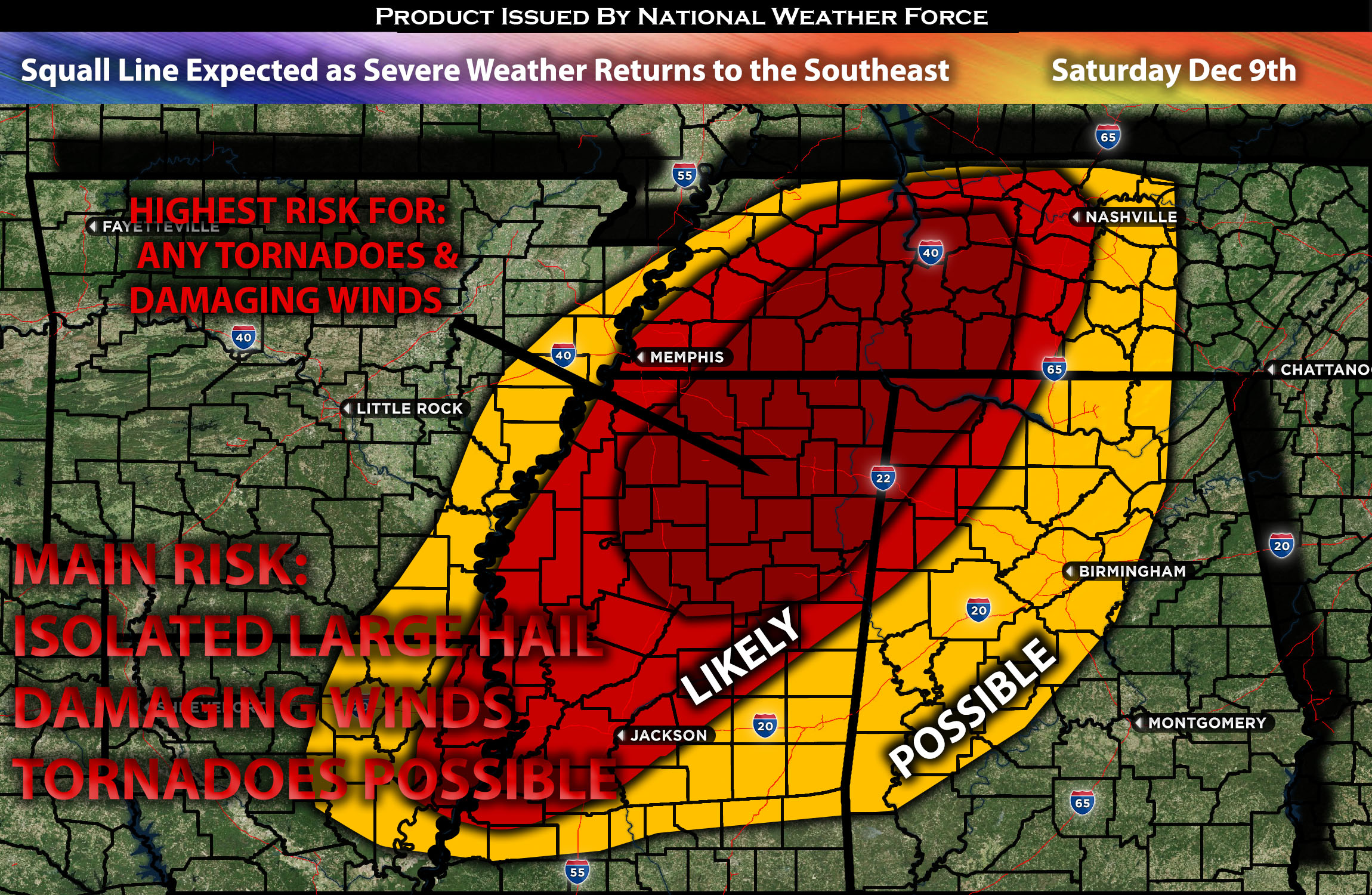
From Northeastern LA Through TN:
An unstable airmass is expected to affect the area from Louisiana through Tennessee, with the bulk of the severe weather potential primarily in Mississippi and Tennessee west and central. These storms are capable of producing damaging winds and a few tornadoes, given the presence of favorable conditions. The main risk is expected to be damaging winds, particularly as a squall line is anticipated to form. More details are provided below.
Cities to be Impacted:
AR: Little Rock, Pine Bluff
LA: Shreveport, Monroe
TN: Memphis, Jackson, Nashville
AL: Tuscaloosa, Birmingham, Huntsville
MS: Jackson, Tupelo, Starkville
Forecast Details:
In the upper levels of the atmosphere, a positively tilted trough is expected to move towards the central U.S. by Saturday. Within the upper-level trough, a shortwave trough is anticipated to move eastward throughout the day across the region expected to be impacted. At the surface, an advancing cold front will move across the central U.S., with warm moisture ahead of it spread across the southeast and into the Tennessee Valley throughout the day. This, combined with daylight heating and instability values of 1500 J/kg and effective shear over 55 knots, will be more than sufficient for storm cell formation. Given the southwesterly winds, storms will collide very quickly and are most likely to become a squall line, sweeping across Arkansas, Mississippi through Tennessee and eventually overnight through other regions such as Alabama before diminishing overnight on Saturday into Sunday morning. There will also be a tornado risk, particularly over Mississippi north through southwest Tennessee, given the low-level shear values, especially late Saturday evening and overnight. The main risk will be damaging winds as the line moves through ahead of the cold front.
For LA and TX eastward: This area looks to be the weaker portion given the more stable airmass over there. Convective activity will be possible but a lot less organized given the airmass stability. Damaging winds look to be the main risk here and local isolated hail.
Main risk: Damaging straight-line winds, a few tornadoes, and isolated large hail.
Stay tuned for more updates.
Sina⚡⚡
With over a decade of experience in forecasting severe thunderstorms, this individual is a seasoned forecaster and developer. Their expertise in severe weather forecasting and computer science is entirely self-taught, complemented by a foundation in Atmospheric Science from UNCO and an IT background from WGU. They have dedicated their efforts to developing innovative tools that enhance the accuracy of analyzing large hail and tornadoes. As a significant contributor to National Weather Force & Southern California Weather Force, they have played a crucial role in providing accurate and timely information, as well as developing tools to keep those affected well-informed.