
 Outlook for Alabama:
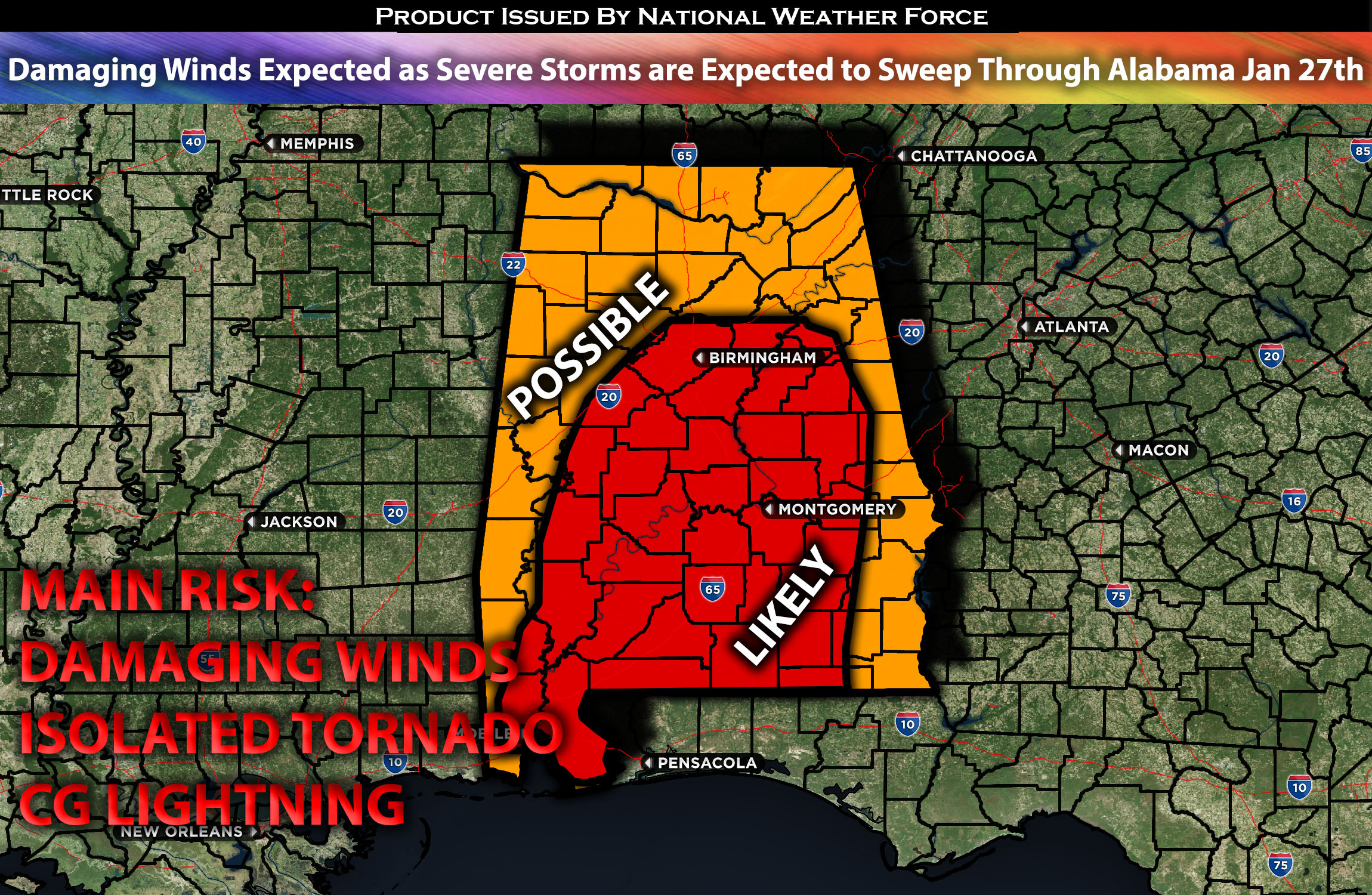
Strong to severe thunderstorms are likely across the AL especially to the central and southern portion before the cold front sweeps through late afternoon. These storms will be capable of producing damaging straight-line winds, and perhaps an isolated tornado, given the slight veering with height; however, this is limited due to buoyancy. These storms are expected to mainly impact the area throughout the morning and into the afternoon before moving eastward and diminishing. Please check below for further details on the forecast.
Main impact: damaging winds, CG lightning, and isolated tornado possible.
Approximate Timing: Expected to form around the morning hours through afternoon before the cold front pushes through quickly from west to east.
Overall Forecast: In the mid/upper levels of the atmosphere, a trough with a maximum will be located over the upper MS Valley during the morning hours of Saturday. Simultaneously, a low-level jet with winds exceeding 50 knots will also be situated right over the region. At the surface, a cold front and a surface low will be present across the region, with the cold front expected to sweep across Alabama and portions of Florida. Ahead of the cold front, warm air advection will occur over the region, combined with elevated but not robust instability and some effective shear with DCAPE. This will allow a line of storms to form and sweep ahead of the cold front in the morning hours. These storms will be capable of producing damaging winds and perhaps an isolated tornado, especially if a low-top supercell forms in the southern portions of AL, where more atmospheric spin might be possible. Due to the limited lapse rates and overall instability, hail will not be a significant risk, which also lowers the risk for tornadoes. Therefore, the main risks with this line of storms will be damaging winds, cloud-to-ground lightning, and heavy rainfall.
Timing & Impact: Already ongoing storms ahead of an approaching cold front are expected to sweep across Alabama, with rapid destabilization allowing for more storms to form and strengthen across the area. A few low-top cells ahead of it are capable of producing an isolated tornado. These storms will sweep through around the early morning hours and exit the area by late afternoon as the cold front pushes through. The main risk with these storms will be damaging winds.
Stay tuned for more updates.
Sina⚡⚡
With over a decade of experience in forecasting severe thunderstorms, this individual is a seasoned forecaster and developer. Their expertise in severe weather forecasting and computer science is entirely self-taught, complemented by a foundation in Atmospheric Science from UNCO and an IT background from WGU. They have dedicated their efforts to developing innovative tools that enhance the accuracy of analyzing large hail and tornadoes. As a significant contributor to National Weather Force & Southern California Weather Force, they have played a crucial role in providing accurate and timely information, as well as developing tools to keep those affected well-informed.