
 Outlook for Central & Southern TX:
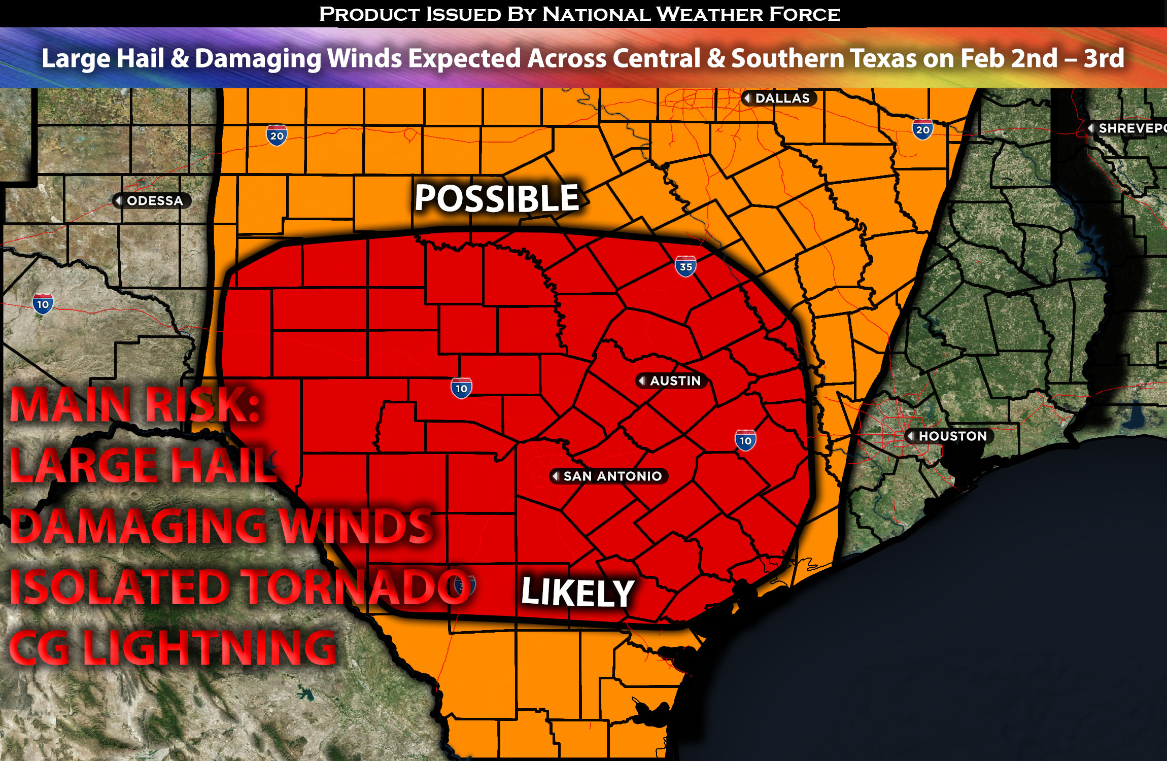
A setup primarily for large hail and perhaps an isolated tornado (low risk) is anticipated across southern Texas and some portions of central Texas, with the focus being further south. These storms will develop similarly to a summer setup, becoming severe quickly, with large hail as the main risk given the conditions. After merging, they will primarily pose a damaging wind threat overnight. For more details on the forecast please check below.
Main impact: large hail, isolated tornado, damaging winds, and CG lightning.
Approximate Timing: Expected to form around the late afternoon pushing eastward ahead of the dryline boundary.
Overall Forecast: In the mid/upper levels of the atmosphere, a jet streak located right over the southwest U.S. is expected to bring a flow over southern Texas with speeds exceeding 60 knots. At the same time, a dryline is expected to be over Texas, especially towards the south, with southerly low-level flow and moderate moisture ahead of it. Combined with elevated effective shear and instability, along with higher lapse rates, this setup will allow a few severe storms to form. These storms are capable of producing large hail, mainly across the impacted area. Additionally, very limited low-level shear will be present over the region, posing a very low risk of an isolated tornado. This risk pertains to any cell that may develop during the evening, especially where shear levels are concentrated over southern Texas. They will then collide overnight/Sat morning with a slight elevated risk for damaging winds and low-end isolated tornado risk in southeast region.
Timing & Impact: The atmosphere is expected to destabilize around late Friday afternoon, between 2-4pm, from western to central Texas, where storms will initiate ahead of the dryline. As they start moving east into a more unstable atmosphere, they are expected to become severe quickly, mainly capable of producing large hail and cloud-to-ground (CG) lightning. Then, they will merge into a line overnight, with a few isolated cells capable of posing a low-level isolated tornado threat in southern Texas towards the coast from Friday night into Saturday morning.
Stay tuned for more updates.
Sina⚡⚡
With over a decade of experience in forecasting severe thunderstorms, this individual is a seasoned forecaster and developer. Their expertise in severe weather forecasting and computer science is entirely self-taught, complemented by a foundation in Atmospheric Science from UNCO and an IT background from WGU. They have dedicated their efforts to developing innovative tools that enhance the accuracy of analyzing large hail and tornadoes. As a significant contributor to National Weather Force & Southern California Weather Force, they have played a crucial role in providing accurate and timely information, as well as developing tools to keep those affected well-informed.