
Outlook for the Southeast Region:
A complex setup is expected across the Southeast as ongoing storms continue to impact Alabama (AL) and Georgia (GA), with more convective activity expected as the system moves eastward. Then, these storms will continue to move eastward, impacting the Carolinas and diminishing overnight on Monday. However, due to the ongoing storms, outflow boundaries have limited the severe weather risk, making the situation much more complex depending on their position. Nevertheless, severe weather remains a risk that must be monitored. For more details on the forecast, please check below.
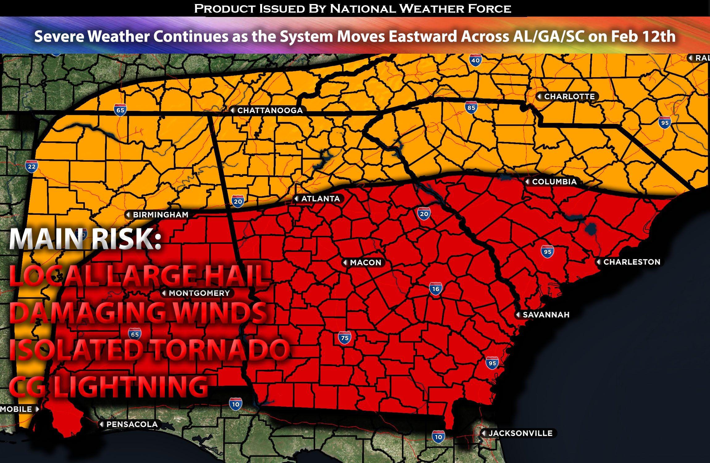
Main impact: large hail, damaging winds, isolated tornado possible, and CG lightning.
Approximate Timing: Expected to be on going in AL/GA area with further convection expected to form ahead of the front with a more concentrated severe weather risk across the southeast and Carolinas through the evening and diminishing overnight.
Overall Forecast: In the mid/upper levels of the atmosphere, a positively tilted trough moving northeastward across the ArkLaTex region is expected to strengthen into a closed cyclone. At the same time, very strong mid-level flow is expected ahead of it over the southeast. At the surface, a low-pressure system with an associated cold front is sweeping eastward, accompanied by a warm front attempting to push northward. However, due to the outflow boundaries of ongoing storms, it is struggling to do so, limiting the warm air advection required for an unstable atmosphere throughout the day. This will delay storms from becoming potentially very strong or severe until later in the day limiting the risk. If the warm front can advect northward sufficiently, the very moist atmosphere ahead of the front, combined with strong instability and a low-level jet over the area, will allow for all hazard types, including large hail, damaging winds, and perhaps isolated tornadoes. However, the more likely scenario appears to be more limited, but it will be monitored for any changes. Nevertheless, damaging winds and perhaps an embedded tornado will be possible with any given storm. Storms will also be ongoing, with many cells across eastern Alabama and the Deep South throughout the morning and afternoon. Then, more convection with stronger storms is expected in the evening hours across Georgia into the Carolinas.
Timing & Impact: Ongoing storms will be all across Alabama and into Georgia through the morning hours, with most of these storms being north of the warm front, which has a much more stable air mass. Given this, the severity of most of these storms will be limited, with mainly local large hail and damaging winds expected. Then, as the front with the system continues to move eastward, another chance for the warm front to move further north is possible, allowing for more convective activity across Georgia and into the Carolinas. However, this will still be limited by how far north the warm front can move, with the unstable air mass remaining below it. Nevertheless, these storms will still be capable of producing damaging winds and perhaps an embedded tornado before the system moves out by Monday night around 9-11 pm EST.
Stay tuned for more updates.
Sina⚡⚡
With over a decade of experience in forecasting severe thunderstorms, this individual is a seasoned forecaster and developer. Their expertise in severe weather forecasting and computer science is entirely self-taught, complemented by a foundation in Atmospheric Science from UNCO and an IT background from WGU. They have dedicated their efforts to developing innovative tools that enhance the accuracy of analyzing large hail and tornadoes. As a significant contributor to National Weather Force & Southern California Weather Force, they have played a crucial role in providing accurate and timely information, as well as developing tools to keep those affected well-informed.