
Outlook for LA, MS, and AL Regions:
A more concentrated severe weather threat is expected across Louisiana (LA), Mississippi (MS), and Alabama (AL) through tonight. Another powerful system moving through the area brings the right conditions for all hazard types, including large hail, damaging winds, and tornadoes, especially with discrete cells. These storms are already ongoing across Louisiana, and further convection is anticipated across the rest of the impacted regions. For more details on the forecast, please check below.
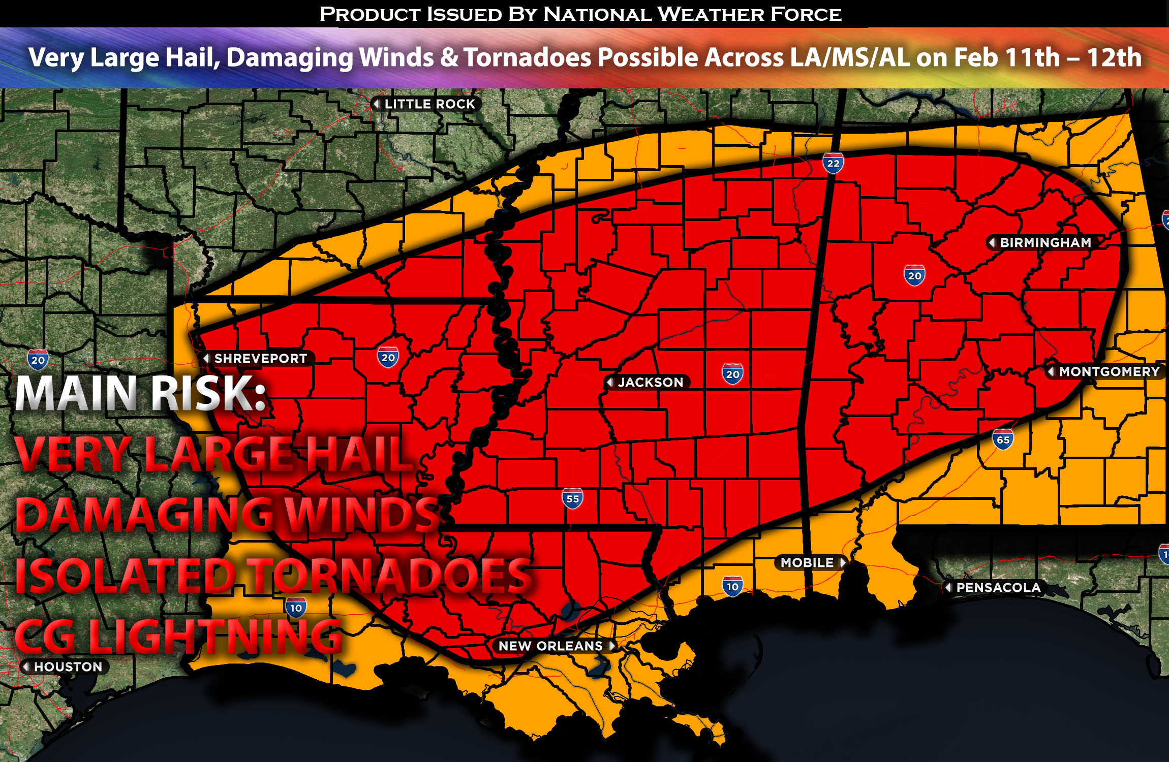
Main impact: large to very hail, damaging winds, tornadoes possible, and CG lightning.
Approximate Timing: Expected to be on going in LA area with further convection expected to form ahead of the front with a more concentrated severe weather risk across MS and into AL.
Overall Forecast: In the mid/upper levels of the atmosphere, a positively tilted trough, becoming neutral and strengthening, is currently over the south-central area, continuing to move eastward. At the same time, an embedded shortwave trough is expected to move eastward into Texas and Oklahoma tonight. At the surface, a low-pressure system with an associated cold front is sweeping eastward, accompanied by a warm front ahead of it pushing northward. Warm advection and a very moist atmosphere ahead of the front, combined with strong instability and a low-level jet over the area, will allow for all hazard types, including large hail, damaging winds, and tornadoes. Storms will also be ongoing, with many cells across eastern Texas into the Louisiana area. Then, more convection with stronger storms is expected in the evening hours across Mississippi.
Timing & Impact: Ongoing storms are anticipated across Louisiana and into Mississippi soon, with more convection expected across the area during this afternoon and evening. These storms will come in waves, with many discrete cells also expected across central Louisiana, Mississippi, and into the Alabama region, capable of producing all hazard types. Then, another round of severe storms is anticipated into the later evening and overnight hours, with more severe weather, including all hazard types, once again across the central regions of Mississippi and Alabama.
Stay tuned for more updates.
Sina⚡⚡
With over a decade of experience in forecasting severe thunderstorms, this individual is a seasoned forecaster and developer. Their expertise in severe weather forecasting and computer science is entirely self-taught, complemented by a foundation in Atmospheric Science from UNCO and an IT background from WGU. They have dedicated their efforts to developing innovative tools that enhance the accuracy of analyzing large hail and tornadoes. As a significant contributor to National Weather Force & Southern California Weather Force, they have played a crucial role in providing accurate and timely information, as well as developing tools to keep those affected well-informed.