
 Outlook for the Valleys of Central/Northern CA:
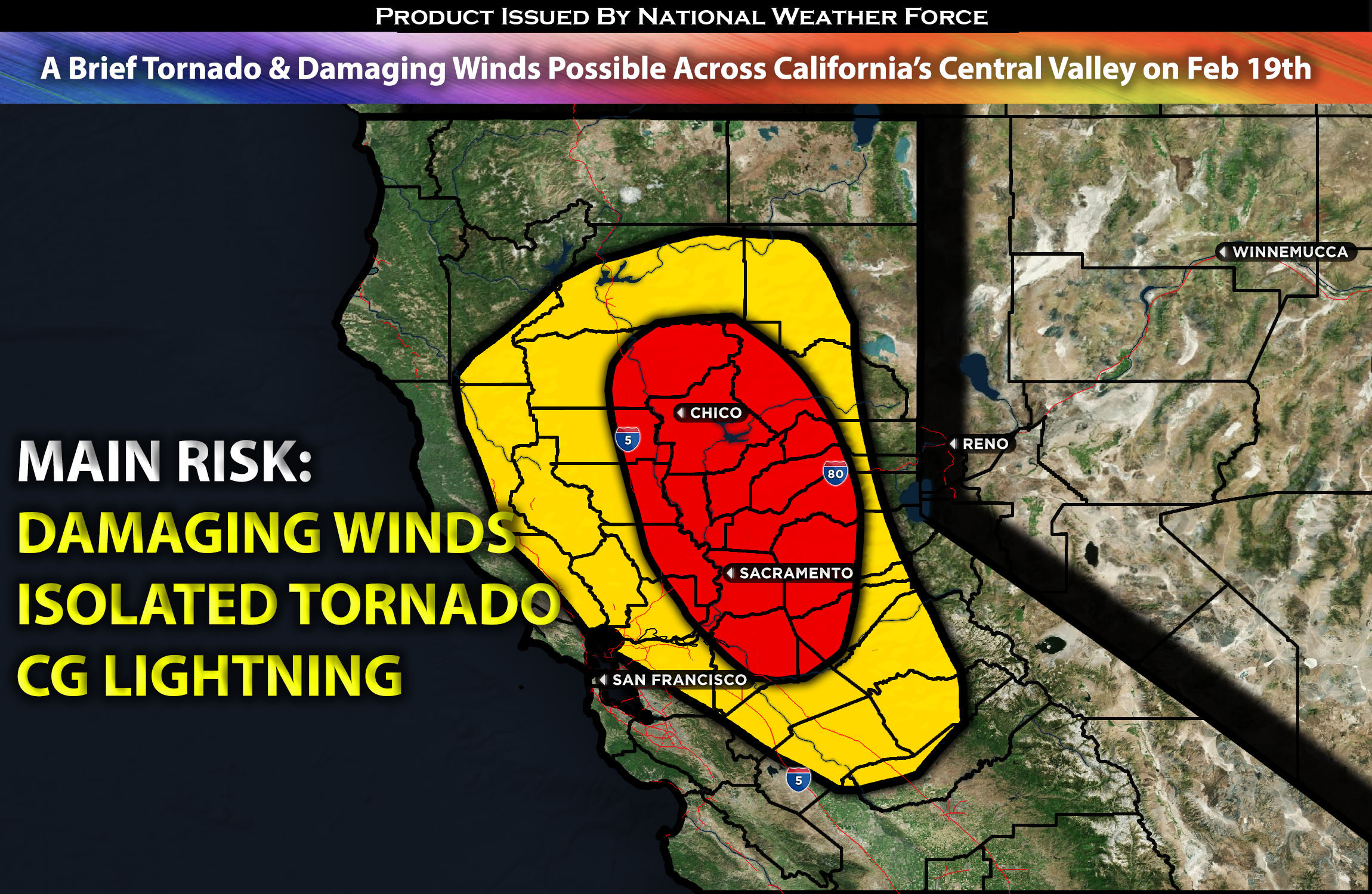
A classic severe weather setup for Northern California is expected on Monday afternoon into the evening hours. These storms will be capable of producing brief heavy rain, a brief tornado, local damaging winds, and perhaps some hail as well, given the dynamics. These storms will be concentrated especially over the valleys of northern/central California, where the necessary ingredients will be most prevalent. For more details on the forecast, please check below.
Main impact: hail, damaging winds, isolated brief tornado possible, and CG lightning.
Approximate Timing: Storms are expected to form and become strong or potentially severe around the afternoon into the evening hours before diminishing as the airmass stabilizes.
Overall Forecast: As a trough in the mid-levels of the atmosphere, accompanied by a surface cyclone, passes over the California Coast on Monday, it will bring low-level moisture advection. Surface dew points will be in the 50s, and the temperature differences with height beneath the cold temperatures aloft will create a somewhat unstable air mass across the valleys in northern/central California. At the same time, this moisture will lift sufficiently, combined with low-level shear created by winds funneling through the valleys. This results in southeasterly winds over the area, further enhancing low-level shear. Combining that with elevated low-level instability due to the cold air aloft will allow thunderstorms to form, including a few that may become low-topped cells, potentially becoming strong or severe. These storms will be capable of producing a brief tornado and, perhaps, some local damaging winds. Additionally, if there is sufficient lifting and freezing within the storms, a few may also produce hailstorms.
Timing & Impact: Initially, a dry air mass will prevent storms from forming. Then, as warm low-level moisture advects across the area and combines with low-level shear and elevated instability, destabilization will occur sometime in the afternoon and into the evening hours. These storms will pop up over the area like popcorn, in a hit-or-miss fashion. This pattern will continue, along with scattered thunderstorms possible in the surrounding areas and valleys of Northern and Central California. These storms will then dissipate as the air mass stabilizes again later overnight.
Stay tuned for more updates.
Sina⚡⚡
With over a decade of experience in forecasting severe thunderstorms, this individual is a seasoned forecaster and developer. Their expertise in severe weather forecasting and computer science is entirely self-taught, complemented by a foundation in Atmospheric Science from UNCO and an IT background from WGU. They have dedicated their efforts to developing innovative tools that enhance the accuracy of analyzing large hail and tornadoes. As a significant contributor to National Weather Force & Southern California Weather Force, they have played a crucial role in providing accurate and timely information, as well as developing tools to keep those affected well-informed.