
 Outlook for the Ozarks/Mid Mississippi and the Southwestern Great Lakes:
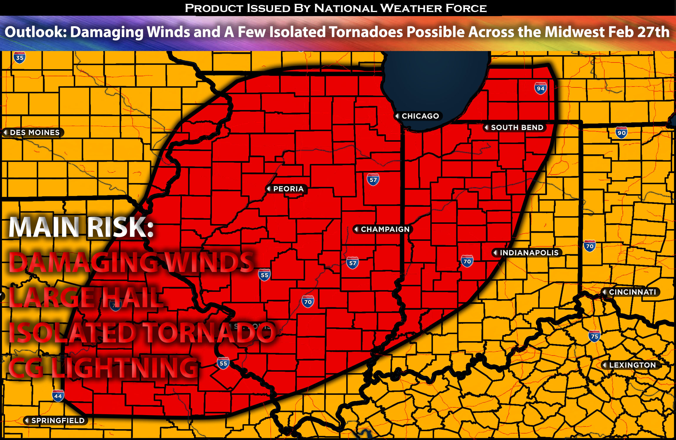
A system is expected to impact the Ozarks/Mid Mississippi and the Southwestern Great Lakes starting late Tuesday afternoon into the evening and overnight hours. These storms will be capable of producing damaging winds as they bow out, large hail locally, and perhaps a few isolated tornadoes. For preliminary forecast check below for details.
Forecast Outlook (Most likely to change and be more In-depth with the next update):
On Tuesday, an upper-level trough will move eastward into the central Rockies and northern Plains, bringing winds from the west-southwest across much of the central and eastern U.S. Moisture will move upward into the mid Mississippi Valley and southwestern Great Lakes, reaching as far north as southern lower Michigan, before the main weather system arrives. A cold front will also move southeastward into the middle to upper Mississippi Valley, setting the stage for thunderstorms to begin in the early evening, especially in central Illinois and north-central Indiana. These thunderstorms are expected to increase and spread southward into the mid Mississippi Valley and northern Ozarks as the evening progresses. At this time, the air won’t be very moist, with only a slight increase in humidity expected in the mid Mississippi area. This means the energy available for storms will be on the lower side. Despite this, the conditions will still be conducive to the formation of scattered thunderstorms that could become severe, especially in north-central Illinois where the air is moistest and where the most effective shear is also present. These storms will be capable of producing damaging winds, large hail locally, and perhaps a few isolated tornadoes.
Potential risk: damaging winds, local large hail, a few isolated tornadoes possible.
Stay tuned for the next update, which will provide timing details, more specific information on impacted locations, and threats for specific micro-zones in the coming days.
Sina⚡⚡
With over a decade of experience in forecasting severe thunderstorms, this individual is a seasoned forecaster and developer. Their expertise in severe weather forecasting and computer science is entirely self-taught, complemented by a foundation in Atmospheric Science from UNCO and an IT background from WGU. They have dedicated their efforts to developing innovative tools that enhance the accuracy of analyzing large hail and tornadoes. As a significant contributor to National Weather Force & Southern California Weather Force, they have played a crucial role in providing accurate and timely information, as well as developing tools to keep those affected well-informed.