
 Outlook for the Central and Southern Plains:
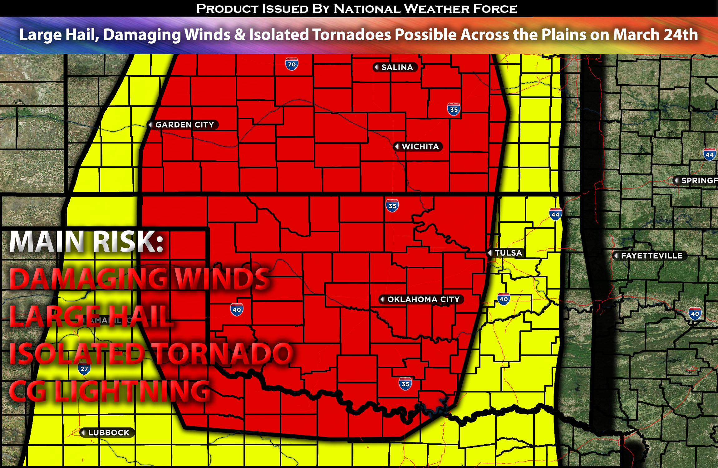
An elevated severe weather risk is anticipated across the central and southern Plains on Sunday. These storms are expected to develop across the Oklahoma/Kansas area and move northeast. They are primarily capable of producing large hail and damaging winds, with also a risk of isolated tornadoes. Check below for more details.
Main impact: large hail, damaging winds, isolated tornado and CG lightning.
Approximate Timing: Depending on when destabilization can occur storms would be expected to pop around afternoon hours and through the evening/late evening.
Locations Impacted: Kansas southcentral, south, KS bordering OK and portions of western OK.
Overall Forecast:
The general agreement among weather forecasts suggests that dewpoints in the low 50s will be present over western Oklahoma early Sunday morning, with higher dewpoints remaining south of the Red River. Dewpoints in the low to mid-60s are expected along the Lower Texas Coast. A significant mass response is anticipated, with strong low-level winds promoting a notable return of moisture. Despite this, dewpoints are likely to remain in the low to mid-50s across western Oklahoma as the dryline advances into the area during the afternoon. Additionally, precipitation in the early period and widespread cloud cover will moderate heating, particularly from the central parts of Kansas and Oklahoma eastward/northeastward. Consequently, although the overall upper-level pattern and associated wind fields align with those typically seen in southern/central Plains severe weather events, the absence of more substantial low-level moisture will serve as a significant constraint. However, a few cells are anticipated especially across the border of KS/OK moving northeast and are expected be become a cluster quickly. Storms will be capable of producing large hail, damaging winds, and isolated tornadoes (although limited).
Impact:
Storm initiation is most likely to occur in southwest Kansas during the late afternoon (around 3-5pm) near the surface low. This area may experience slightly deeper boundary-layer mixing, with dewpoints anticipated to be in the mid 40s. Despite these conditions, the combination of cold mid-level temperatures and strong upward motion—driven by the approaching shortwave trough and more localized dynamics near the low and dryline—should support storm development of severe cluster of storms. The vertical wind profiles in this region favor storm organization, with an initial phase of discrete supercell storms expected before clustering up then dissipating in a more stable airmass. In contrast, further south across western Oklahoma and northwest Texas, storm initiation is more uncertain due to warmer low to mid-level temperatures and weaker broad-scale ascent. As a result, these areas present a more conditional potential for storm development, with favorable wind profiles that could aid in organizing any developing updrafts. The storms that do form will be capable of producing large hail, damaging winds, and isolated tornadoes, albeit within a limited time frame.
Stay tuned for more updates.
Sina⚡⚡
With over a decade of experience in forecasting severe thunderstorms, this individual is a seasoned forecaster and developer. Their expertise in severe weather forecasting and computer science is entirely self-taught, complemented by a foundation in Atmospheric Science from UNCO and an IT background from WGU. They have dedicated their efforts to developing innovative tools that enhance the accuracy of analyzing large hail and tornadoes. As a significant contributor to National Weather Force & Southern California Weather Force, they have played a crucial role in providing accurate and timely information, as well as developing tools to keep those affected well-informed.