
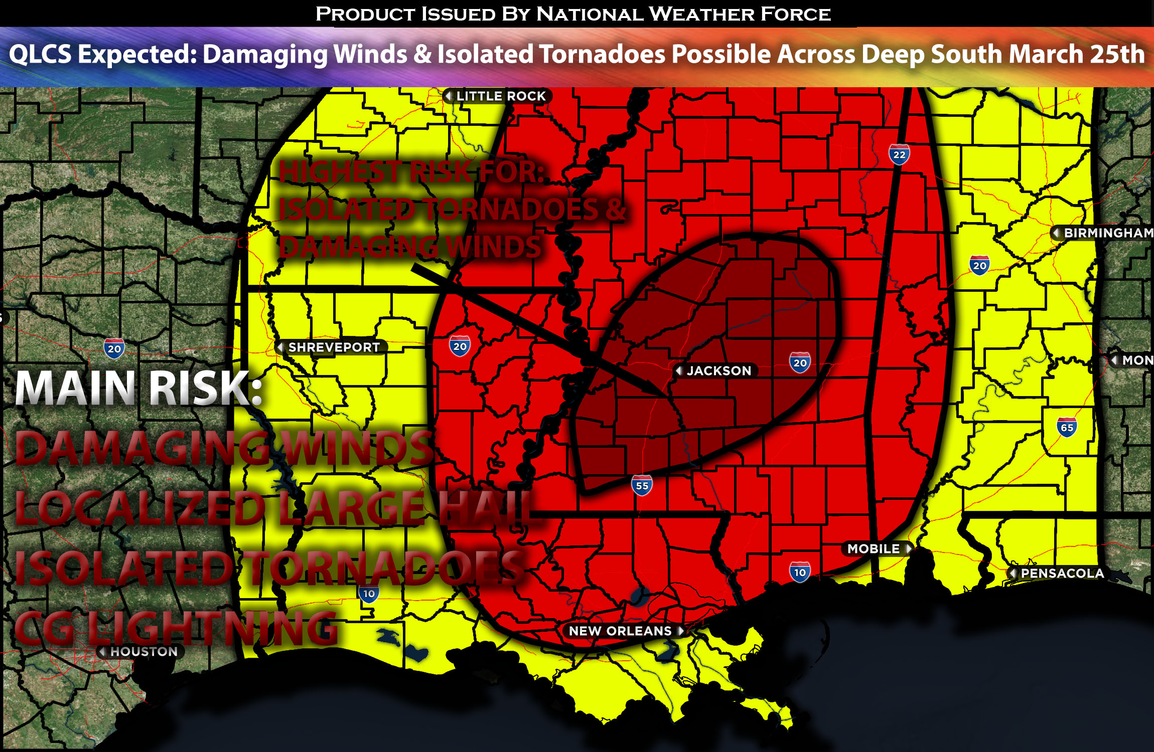
 Outlook for the Deep South (Concentrated Across MS):
Another robust severe weather threat continues across the Deep South as the system pushes eastward. These storms will be capable of producing large hail, damaging winds, and perhaps also a few embedded isolated tornadoes, especially across Mississippi. Check below for more details.
Overall Forecast:
Deep upper troughing is expected across the central U.S., with several shortwave troughs embedded within this extensive parent troughing, including one over the Missouri Valley and another over the southern Plains. The northern shortwave is predicted to move northward through the Mississippi Valley, while the southern shortwave will quickly move northeastward across Oklahoma/northeast Texas and eastward with time. The development of these shortwaves, especially the one originating from the southern High Plains, will cause the parent upper trough to become more negatively tilted as the entire system gradually moves eastward across the area. Low-level moisture will be present ahead of the convective line early Monday, extending from southwest Missouri through northeast Texas, providing modest buoyancy despite widespread cloud cover and relatively cool surface temperatures. Initial modest convection is likely within this line early Monday. However, there is an expectation for the line to re-intensify during the early afternoon due to increased large-scale forcing, the cold front catching up to the line, and peak daily buoyancy.
This re-intensification is anticipated to start near the Texas/Louisiana border, with storms reaching maximum intensity across far southeast Arkansas, eastern Louisiana, and western Mississippi. The region is expected to experience very strong wind fields and shear, with southeasterly surface winds ahead of the line creating large, looping low-level hodographs. Furthermore, strong southwesterly mid-level flow will contribute to a southwesterly deep-layer shear vector with a significant line-perpendicular orientation. This setup is likely to support a robust, forward-propagating line capable of strong gusts and embedded QLCS tornadoes.
Given the line’s expected initial weakness, there may also be a chance for more discrete updrafts as the line begins to re-intensify, especially towards the southern portions. As the system moves eastward into Alabama, the air mass will become less unstable, leading to an expectation of the line’s overall intensity weakening as it progresses into Alabama overnight. At the same time, low-level moisture will be present ahead of the convective line early Monday, extending from southwest Missouri through northeast Texas, providing modest buoyancy despite widespread cloud cover and relatively cool surface temperatures. Then re-intensification is anticipated to start near the Texas/Louisiana border, with storms reaching maximum intensity across far southeast Arkansas, eastern Louisiana, and western Mississippi. The region is expected to experience very strong wind fields and shear, with southeasterly surface winds ahead of the line creating large, looping low-level hodographs. Furthermore, strong southwesterly mid-level flow will contribute to a southwesterly deep-layer shear with a significant line orientation. This setup is likely to support a robust, forward-propagating line capable of strong gusts and embedded QLCS tornadoes within them. Given the line’s expected initial weakness, there may also be a chance for more discrete updrafts as the line begins to strengthen again, especially towards the southern portions. As the system moves eastward into Alabama, the air mass will become less unstable, leading to an expectation of the line’s overall strength weakens as it progresses into Alabama area through the overnight hours.
Impact:
Ongoing strong to severe storms are anticipated from the morning into the afternoon hours on Monday across the AR/LA area before intensification occurs with a more unstable air mass across the MS area. A QLCS with discrete cells is expected to sweep through the area around the late afternoon into the evening hours across MS. These storms will be capable of producing large hail, damaging winds, and a few embedded isolated tornadoes. The storms will then move into AL, where a more stable air mass overnight will decrease the threat for severe storms.
Main impact: damaging straight-line winds, isolated tornadoes and CG lightning.
Approximate Timing: Ongoing storms expected with more strengthening severe storms around impacting the regions of MS where the most concentrated threat will be around the evening hours.
Locations Impacted: AR and LA, sweeping through MS (concentrated area) before losing its strength as it enters AL from the west.
Stay tuned for more updates.
Sina⚡⚡
With over a decade of experience in forecasting severe thunderstorms, this individual is a seasoned forecaster and developer. Their expertise in severe weather forecasting and computer science is entirely self-taught, complemented by a foundation in Atmospheric Science from UNCO and an IT background from WGU. They have dedicated their efforts to developing innovative tools that enhance the accuracy of analyzing large hail and tornadoes. As a significant contributor to National Weather Force & Southern California Weather Force, they have played a crucial role in providing accurate and timely information, as well as developing tools to keep those affected well-informed.