
Outlook From the Southern Plains Stretching into the Ozarks and Parts of the Ohio Valley:
A concentrated severe weather outbreak is possible across a wide area on Monday, including the southern Plains, the Ozarks, and parts of the Ohio Valley, with potential for large to very large hail, damaging winds, and tornadoes. The peak of the severe threat in the southern Plains is expected this afternoon and evening, while for the Ohio Valley area, the most significant threat is anticipated during the evening and overnight period.
Overall Forecast:
Monday, a large, positively tilted upper-level trough will move eastward from the Southwest to the central Plains. Accompanied by a mid-level shortwave trough, which is currently navigating the base of this larger trough, it will progress quickly northeast throughout the day within a strong mid-level jet. This dynamic will spread over a very moist warm sector, setting the stage for severe weather from the Southern Plains into the Midwest.
A surface low is projected to move eastward, with a warm front advancing northward during the afternoon, alongside a stationary front that extends eastward across Kansas and Missouri into the Ohio Valley. Dewpoints in the mid-60s are anticipated across much of the warm sector east of the dryline by midday. Moderate to strong instability is expected to build up as the ascent from the approaching trough meets the dryline, leading to rapid storm development along the dryline from southern Kansas to north Texas. The presence of very strong effective shear and mostly straight hodographs will facilitate splitting supercells, initially capable of producing large to potentially giant hail across a wide region from southwest Missouri to northern Texas.
Low-level shear will likely be very weak throughout much of the day, which will constrain the tornado threat. However, by the evening, as the low-level jet strengthens with the advancing wave, low-level shear is expected to improve. The most conducive hodographs for tornadoes are forecasted across northeast Oklahoma into southeast Kansas and southwest/central Missouri, where mature supercells are likely to be active. As a result, a more possible period for tornadoes, including the possibility of a strong tornado, may arise from the evening into the early overnight hours, especially as low-level shear becomes more concentrated.
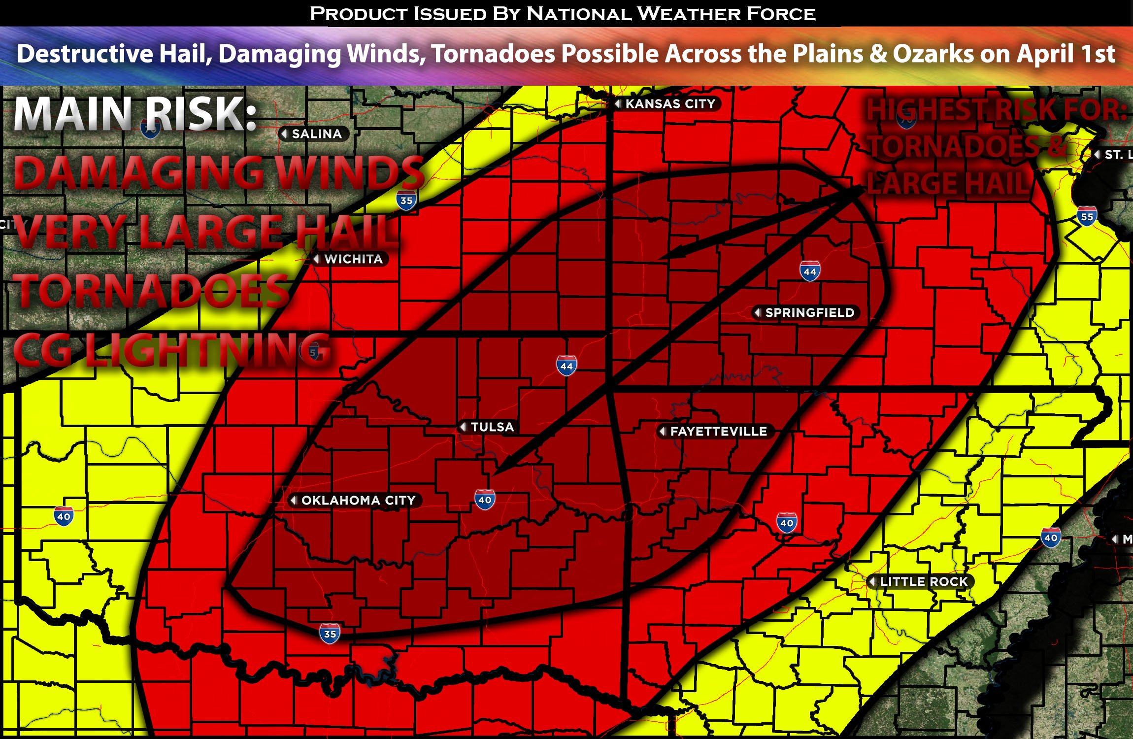
Main impact: very large hail, damaging winds, tornadoes possible and CG lightning.
Approximate Timing: Depending on when destabilization occurs, sometime around the early evening into the overnight hours, severe storms are expected to form along and ahead of the dry line across Oklahoma, Kansas, and Missouri as a cluster with isolated cells within them capable of producing large to very large destructive hail, damaging straight-line winds, and, during the evening’s peak time of low-level shear, a few tornadoes, perhaps even a strong one, across portions of northeastern Oklahoma into southeast Kansas and southwest/central Missouri. These storms are expected to cluster overnight as an MCS, continuing through Missouri and southwestern portions of Arkansas, moving eastward with time before decreasing in strength into the morning hours of Tuesday.
Locations Impacted: The majority of Oklahoma and Missouri, portions of KS south, southeast, extending into Arkansas, (especially the northwest).
Stay tuned for more updates.
Sina⚡⚡
With over a decade of experience in forecasting severe thunderstorms, this individual is a seasoned forecaster and developer. Their expertise in severe weather forecasting and computer science is entirely self-taught, complemented by a foundation in Atmospheric Science from UNCO and an IT background from WGU. They have dedicated their efforts to developing innovative tools that enhance the accuracy of analyzing large hail and tornadoes. As a significant contributor and partner at National Weather Force Innovations LLC, they have played a crucial role in providing accurate and timely information. Additionally, they have been instrumental in developing tools and organizing projects that focus on accuracy and performance, ensuring those affected are well-informed.