
 Outlook Across Northern TX Stretching to Central TX:
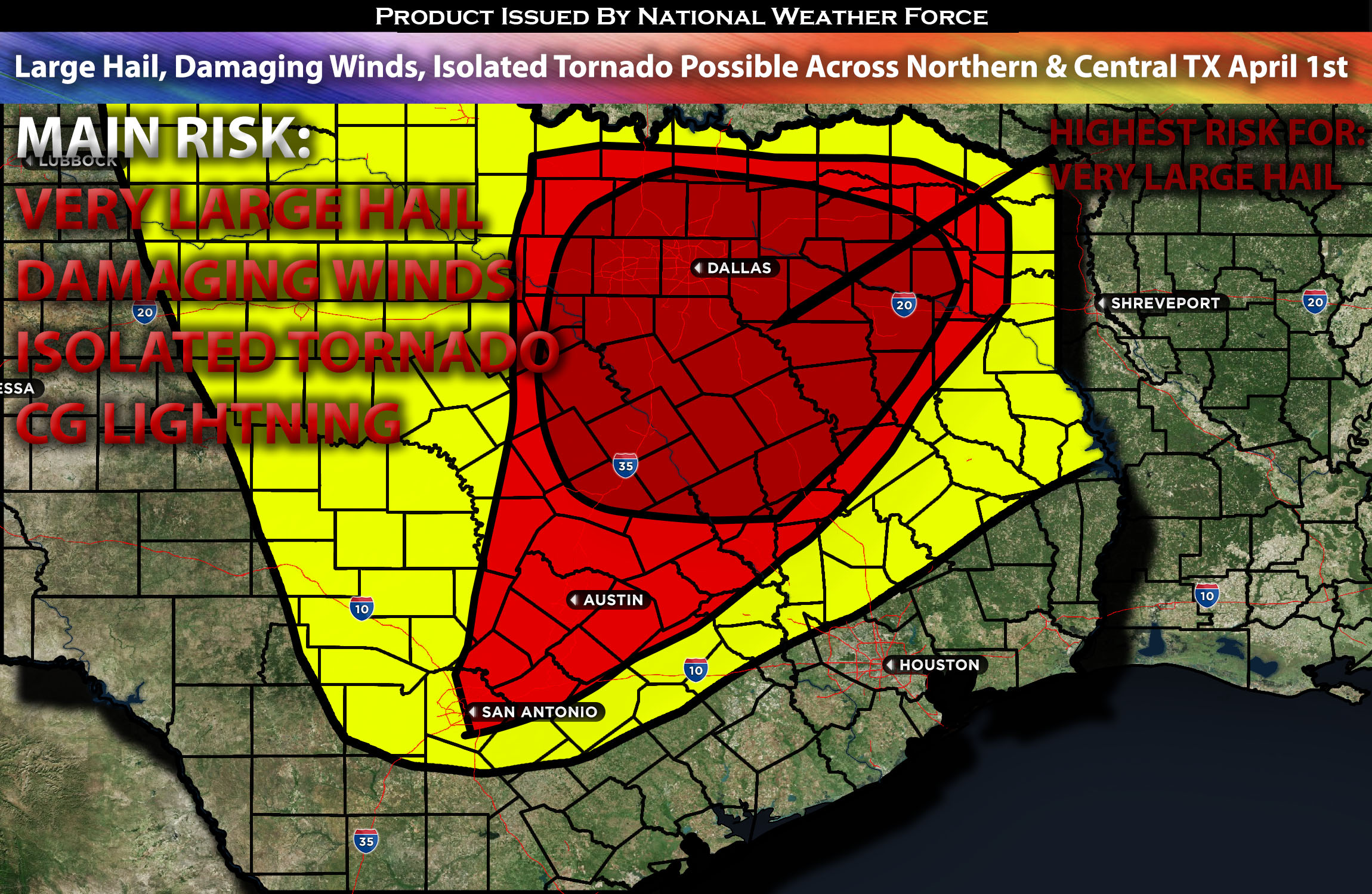
Severe weather is possible across northern Texas, stretching into central Texas, with the greatest concentration of threats being further north. These storms will be capable of producing large to very large hail, damaging winds, and perhaps an isolated tornado.
Overall Forecast:
On Monday, an expansive, positively tilted upper-level trough is scheduled to move eastward from the Southwest into the central Plains, closely followed by a mid-level shortwave trough currently making its way along the base of the larger trough. Driven by a strong mid-level jet stream, this configuration will quickly move northeast, bringing in a very moist warm sector that is conducive to severe weather, starting in the Southern Plains. For more information on the area from Oklahoma northeastward, where the most concentrated severe weather is forecasted, please refer to our other advisory/article.
As the surface low shifts eastward and a warm front moves north in the afternoon, along with a stationary front extending east across Kansas and Missouri into the Ohio Valley, significant weather activity is expected. By midday, dewpoints are projected to reach the mid-60s in much of the warm sector east of the dryline, generating moderate to strong instability. In Texas, this heightened instability, together with the ascent from the nearing trough, is anticipated to catalyze rapid storm development along the dryline, from northern Texas stretching southward. The interplay of very strong effective shear and predominantly straight hodographs will facilitate the emergence of splitting supercells, initially capable of yielding large to potentially giant hail across a wide region, particularly in northern Texas. The combination of strong effective shear, ranging from elevated to strong instability, and a significant moisture level, is expected to precipitate severe storms that can produce large to very large hail, damaging winds, and possibly isolated tornadoes, impacting areas from northern to central and perhaps southern Texas. The main risk is projected to be very large hail, with a heightened tornado threat anticipated further north into the Oklahoma/Missouri area. Nevertheless, discrete cells are still capable of generating an isolated tornado.
Main impact: very large hail, damaging winds, isolated tornado possible and CG lightning.
Approximate Timing: Depending on when destabilization occurs, sometime around the early evening into the overnight hours, severe storms are expected to form along and ahead of the dry line across Texas, especially in northern TX, as a cluster with isolated cells within them capable of producing large to very large destructive hail, damaging straight-line winds, and perhaps an isolated tornado. These storms will move quickly eastward/northeastward.
Locations Impacted: North Texas, Northeast Texas and Central Texas
Stay tuned for more updates.
Sina⚡⚡
With over a decade of experience in forecasting severe thunderstorms, this individual is a seasoned forecaster and developer. Their expertise in severe weather forecasting and computer science is entirely self-taught, complemented by a foundation in Atmospheric Science from UNCO and an IT background from WGU. They have dedicated their efforts to developing innovative tools that enhance the accuracy of analyzing large hail and tornadoes. As a significant contributor and partner at National Weather Force Innovations LLC, they have played a crucial role in providing accurate and timely information. Additionally, they have been instrumental in developing tools and organizing projects that focus on accuracy and performance, ensuring those affected are well-informed.