
 Outlook Across the Corn Belt/MO Valleys:
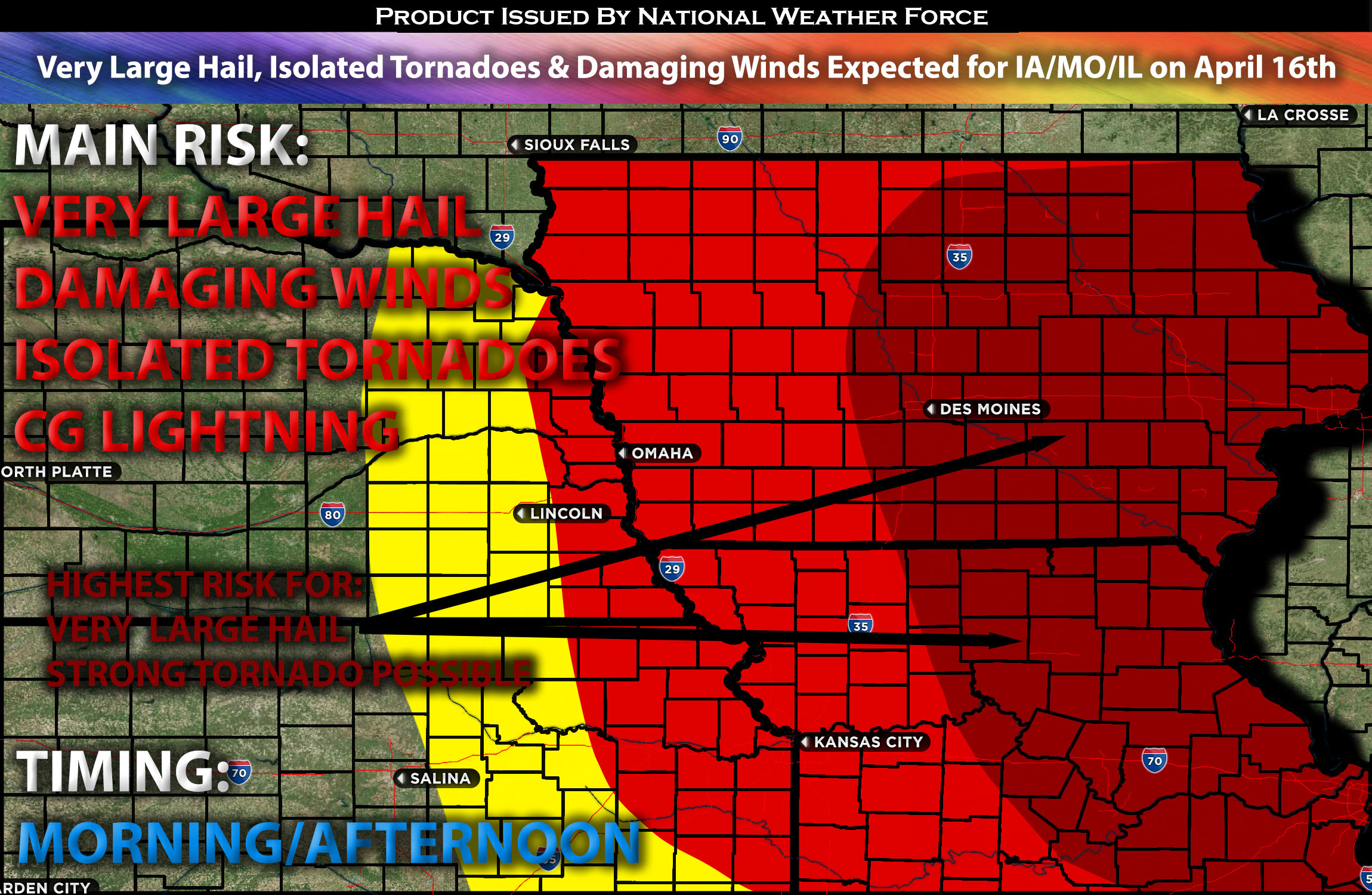
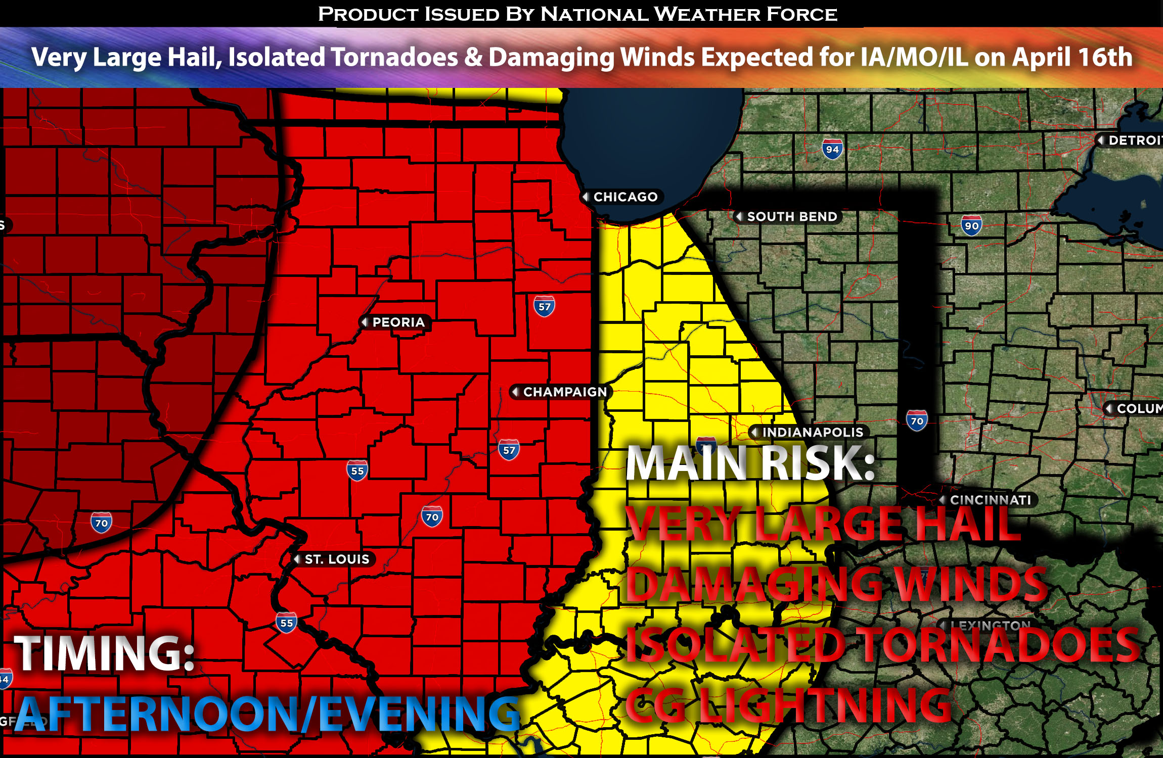
Severe storms are highly likely on Tuesday morning, continuing into the evening across parts of the central states, spanning from the Corn Belt to the Missouri Valley. The area with the highest potential for significant severe hail and isolated tornadoes possible in southern Iowa, northern Missouri, and western IL although this will occur in a very short timeframe when conditions are optimal. Please see below for further details, including timing, impact, and the risk area.
Overall Forecast:
A complex setup is expected which makes it more difficult to pan out read further for details. A powerful upper-level low featuring a negatively tilted shortwave trough is set to move eastward, bringing a strong atmospheric flow to the region, particularly over the High Plains where a low-pressure system is undergoing maturation. Over the next couple of days, this system is expected to head east toward the Mississippi River Valley, with forecasts placing it near northern Iowa by late Tuesday afternoon or early evening as it begins to lose its defining structure.
Storms will primarily be concentrated within a zone of warm air moving ahead of the system, at an existing outflow boundary from morning convection, and along a cold front trailing the low. Throughout the morning, storm activity is expected to strengthen across northern Missouri and central Iowa as the warm sector, characterized by moisture and weak atmospheric capping, heats up with the day. Although the temperature drop with height at mid-levels is somewhat limited, which will restrain the instability levels to 1000 J/kg, the pronounced change in wind direction and speed in the lowest 2 kilometers, combined with swift 65 knot winds higher up, could foster the early development of supercells capable of producing a variety of severe weather hazards.
The most intense storms are forecasted for the eastern side of the surface low, at the northern edge of a warm and dynamically favorable zone where significant uplift will meet an air mass that’s ripe for storm formation, further aided by favorable wind shear near the surface. However, the window for these conditions to align perfectly is narrow, which could limit the potential for a more widespread severe event. Should a few discrete cells manage to rapidly intensify within this extra high-shear zone, there’s a chance for exceptionally large hail and possibly a strong tornado, although only if those dynamics are there.
Nevertheless, any storms that develop alongside the advancing line are expected to bring the threat of very large hail and damaging winds, with the possibility of isolated tornadoes.
Main Risk: very large hail, damaging winds, isolated tornadoes (with a small chance for a strong tornado if in the given dynamic time frame) and cloud-to-ground lightning.
Approximate Timing: Clusters of storms, some severe, are anticipated across eastern Nebraska, western Iowa, and the northwest and northern regions of Missouri as the low-pressure system continues to mature and move eastward with the aligned front throughout the morning. Discrete cells, arising from favorable dynamics during a brief window, could escalate into very powerful supercells with the potential for very large hail and the possibility of a strong tornado (under close monitoring). As the necessary conditions coalesce, multiple cells are expected to form along the borders of Nebraska, Iowa, and northern Missouri, developing into a line capable of producing all types of severe weather across the affected regions by the afternoon and evening. The activity is expected to move eastward and weaken overnight.
Stay tuned for more updates.
Sina⚡⚡
With over a decade of experience in forecasting severe thunderstorms, this individual is a seasoned forecaster and developer. Their expertise in severe weather forecasting and computer science is entirely self-taught, complemented by a foundation in Atmospheric Science from UNCO and an IT background from WGU. They have dedicated their efforts to developing innovative tools that enhance the accuracy of analyzing large hail and tornadoes. As a significant contributor and partner at National Weather Force Innovations LLC, they have played a crucial role in providing accurate and timely information. Additionally, they have been instrumental in developing tools and organizing projects that focus on accuracy and performance, ensuring those affected are well-informed.