
 Outlook:
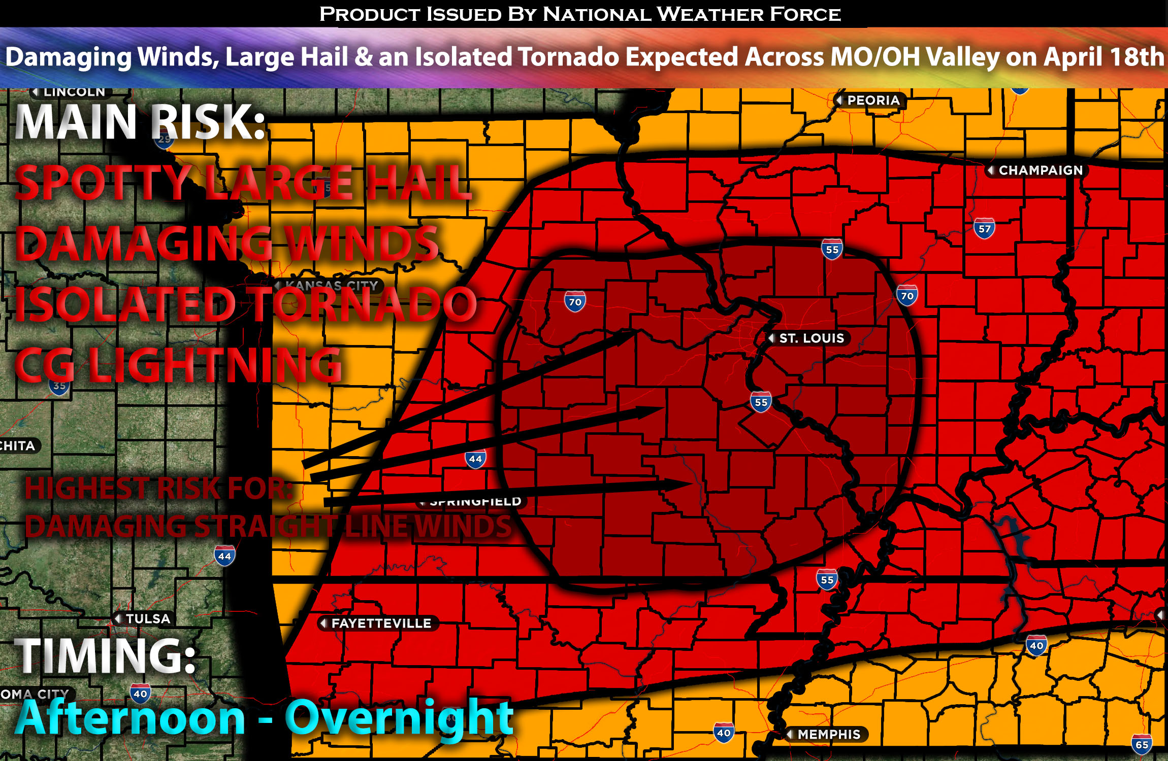
On Thursday, severe storms are expected across parts of Missouri extending into the Ohio Valley, capable of producing damaging winds, large hail, and potentially a few isolated tornadoes. Please see below for further details, including timing, impact, and the risk area.
Overall Forecast for MO into Portions of the OH Valley:
Tomorrow, as a mid-level trough progresses to the northern Plains, expect a flow aloft to overspread the entire area. Concurrently, a gradually weakening surface low will move from the central Plains toward the Ohio Valley while a cold front descends southward from the Ohio Valley to central Texas throughout the day. At the surface, a low will be moving across central Missouri/Illinois during the late morning and afternoon, likely spurring thunderstorm development along and ahead of the cold front, further energized by overnight and morning activity.
As the surface low shifts northeast and the cold front drifts southeast, diurnal heating will promote destabilization ahead of the warm advection over the mid-Mississippi Valley. This process, coupled with deep moisture featuring mid-60s F dewpoints and 7-8 C/km mid-level lapse rates (change in temperature with height), will overspread a deepening and mixing boundary layer. The result will be very strong instability across the area, enhanced by effective shear and significant mid-level flow and associated speed/directional shear. This shear and buoyancy profile will support multicell storm development, characterized by wind and large hail, rapidly growing upscale into a Mesoscale Convective System (MCS) by late afternoon. Given the mixed boundary layer conditions preceding the MCS, it should efficiently produce powerful damaging gusts across the impacted region. Additionally, the setup, including low-level vortices, could also produce isolated tornadoes within the squall line (QLCS).
Main Risk: large hail, powerful damaging winds, isolated tornado possible and cloud-to-ground lightning.
Approximate Timing: Ongoing storms are anticipated across northwestern MO from the previous severe weather setup, with these storms already capable of producing scattered damaging winds. Further storm development is anticipated around central MO as a cluster in the afternoon to late afternoon, likely maturing quickly and possibly becoming an MCS. These storms are expected to rapidly strengthen, capable of very damaging winds, spotty large hail, and a QLCS tornado risk. This QLCS (powerful line of storms) is expected to continue moving eastward/southeastward throughout the night, reaching southern IL and the Ohio Valley before quickly diminishing late at night.
Stay tuned for more updates.
Sina⚡⚡
With over a decade of experience in forecasting severe thunderstorms, this individual is a seasoned forecaster and developer. Their expertise in severe weather forecasting and computer science is entirely self-taught, complemented by a foundation in Atmospheric Science from UNCO and an IT background from WGU. They have dedicated their efforts to developing innovative tools that enhance the accuracy of analyzing large hail and tornadoes. As a significant contributor and partner at National Weather Force Innovations LLC, they have played a crucial role in providing accurate and timely information. Additionally, they have been instrumental in developing tools and organizing projects that focus on accuracy and performance, ensuring those affected are well-informed.