
Outlook:
Scattered severe storms with the potential for damaging winds, large hail, and isolated tornadoes are expected on Thursday. These storms are likely to form along a line from the Great Lakes down into the Ohio Valley during the afternoon and evening, moving eastward with the boundary. Please see below for further details, including timing, impact, and the risk area.
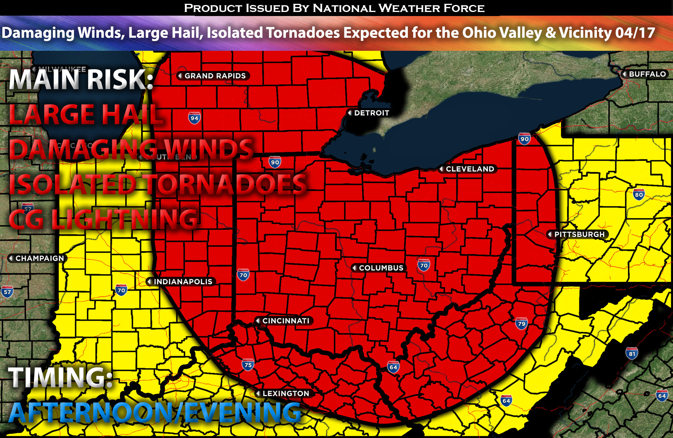
Overall Forecast for the Ohio Valley & Lower Great Lakes:
The upper-level and attendant surface low that recently brought severe weather across the central Plains and Midwest is expected to weaken over the next day as it shifts northeast. Concurrently, a trailing surface cold front linked to the low will continue to advance east, with more storms forming ahead of it across the Great Lakes region. This front is likely to catalyze severe thunderstorm development by early afternoon across Indiana, Ohio, and the surrounding areas, where conditions are favorable. Additionally, as the day progresses, further thunderstorm activity is expected in parts of the Tennessee Valley, spurred by a residual outflow boundary moving eastward.
As the surface low tracks northeast, it is expected to promote warm advection, pushing dewpoints in the low to mid-60s northward into Indiana, Ohio, and lower Michigan by late morning, ahead of an approaching cold front. The diurnal heating of this moist low-level air mass should create sufficient instability by early afternoon, reducing inhibition and setting the stage for robust convection to develop across lower Michigan and western Ohio. Initially, expect discrete cells within a broken line of storms, carrying risks of hail and tornadoes. Strong low-level lapse rates, coupled with 50-knot mid-level flow, are likely to increase the threat of damaging winds as storms cluster. As the day progresses, upscale growth into one or more storm clusters is probable across eastern Ohio and far western Pennsylvania, driven by strong forcing along the front and the continued influence of warm air advection and effective shear.
Main Risk: large hail, damaging winds, isolated tornadoes possible and cloud-to-ground lightning.
Approximate Timing: The main line of storms is expected to form ahead of the cold front. These storms are likely to develop from central Ohio up to eastern Michigan during the afternoon. They are expected to mature quickly and become severe by the afternoon, continuing to move eastward as the front advances. These storms will be capable of producing large hail, damaging winds, and perhaps isolated tornadoes.
Stay tuned for more updates.
Sina⚡⚡
With over a decade of experience in forecasting severe thunderstorms, this individual is a seasoned forecaster and developer. Their expertise in severe weather forecasting and computer science is entirely self-taught, complemented by a foundation in Atmospheric Science from UNCO and an IT background from WGU. They have dedicated their efforts to developing innovative tools that enhance the accuracy of analyzing large hail and tornadoes. As a significant contributor and partner at National Weather Force Innovations LLC, they have played a crucial role in providing accurate and timely information. Additionally, they have been instrumental in developing tools and organizing projects that focus on accuracy and performance, ensuring those affected are well-informed.