
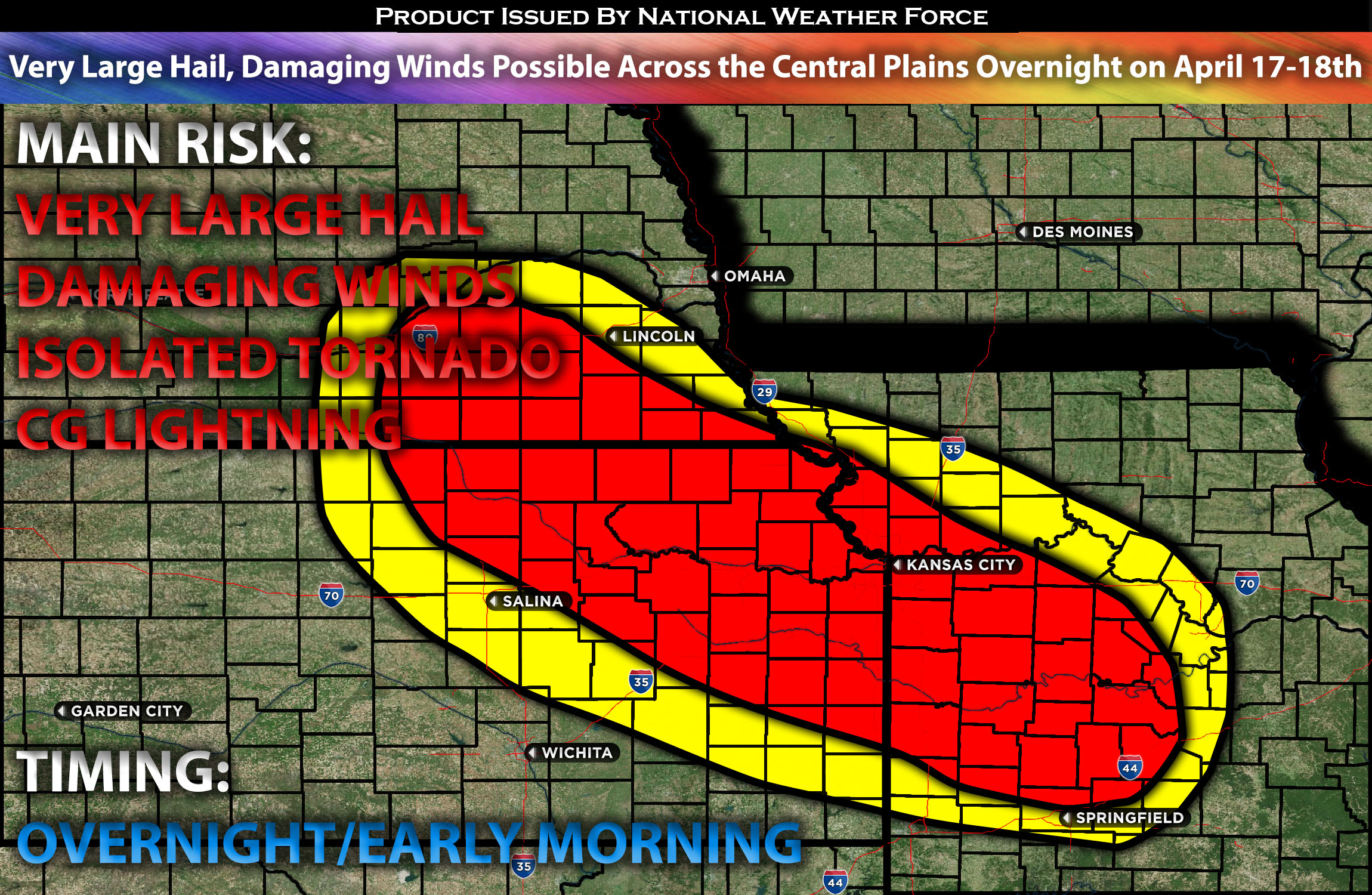
Outlook:
Scattered severe storms are expected across the central plains in the evening and overnight, capable of producing very large hail, damaging winds, and an isolated tornado (although the risk is very low). Please see below for further details, including timing, impact, and the risk area.
Overall Forecast for the Central Plains and into the Ozarks:
In the upper levels of the atmosphere, a trough is expected to traverse the north-central U.S. tonight. Simultaneously, a 50-knot low-level jet will emerge further south over the central Plains, serving as a crucial component for storm development. Storm initiation is anticipated near the northern edge of this low-level jet late this evening, from central Kansas into far southeast Nebraska. These storms are expected to move eastward across northeast Kansas and into western Missouri. They will be driven by very strong instability and effective shear around 45 knots, alongside efficient mid-level lapse rates (change in temperature with height). This setup is conducive to severe storms capable of producing very large hail, which is considered the primary threat, and potentially damaging winds.
Main Risk: very large hail, damaging winds, isolated tornado possible and cloud-to-ground lightning.
Approximate Timing: This will depend on when destabilization occurs, likely around late evening into the overnight. Storms are expected to form across central Kansas, with additional storms developing in southeastern Nebraska. These storms will move quickly eastward and rapidly strengthen, capable of producing very large hail (the main threat). The storms are expected to continue moving east-northeast, eventually reaching northwest Missouri, with the risk transitioning to damaging winds, though large hail will still be a concern through the morning, around 5-10 a.m. CT, before diminishing as a more stable air mass moves in.
Stay tuned for more updates.
Sina⚡⚡
With over a decade of experience in forecasting severe thunderstorms, this individual is a seasoned forecaster and developer. Their expertise in severe weather forecasting and computer science is entirely self-taught, complemented by a foundation in Atmospheric Science from UNCO and an IT background from WGU. They have dedicated their efforts to developing innovative tools that enhance the accuracy of analyzing large hail and tornadoes. As a significant contributor and partner at National Weather Force Innovations LLC, they have played a crucial role in providing accurate and timely information. Additionally, they have been instrumental in developing tools and organizing projects that focus on accuracy and performance, ensuring those affected are well-informed.