
Outlook:
Severe storms are expected from late Thursday afternoon into Thursday night as the atmosphere becomes very unstable across portions of western/northern Texas including possibly the Panhandles. Very large hail, damaging winds, and isolated tornadoes are possible. Please see below for further details, including timing, impact, and the risk area.
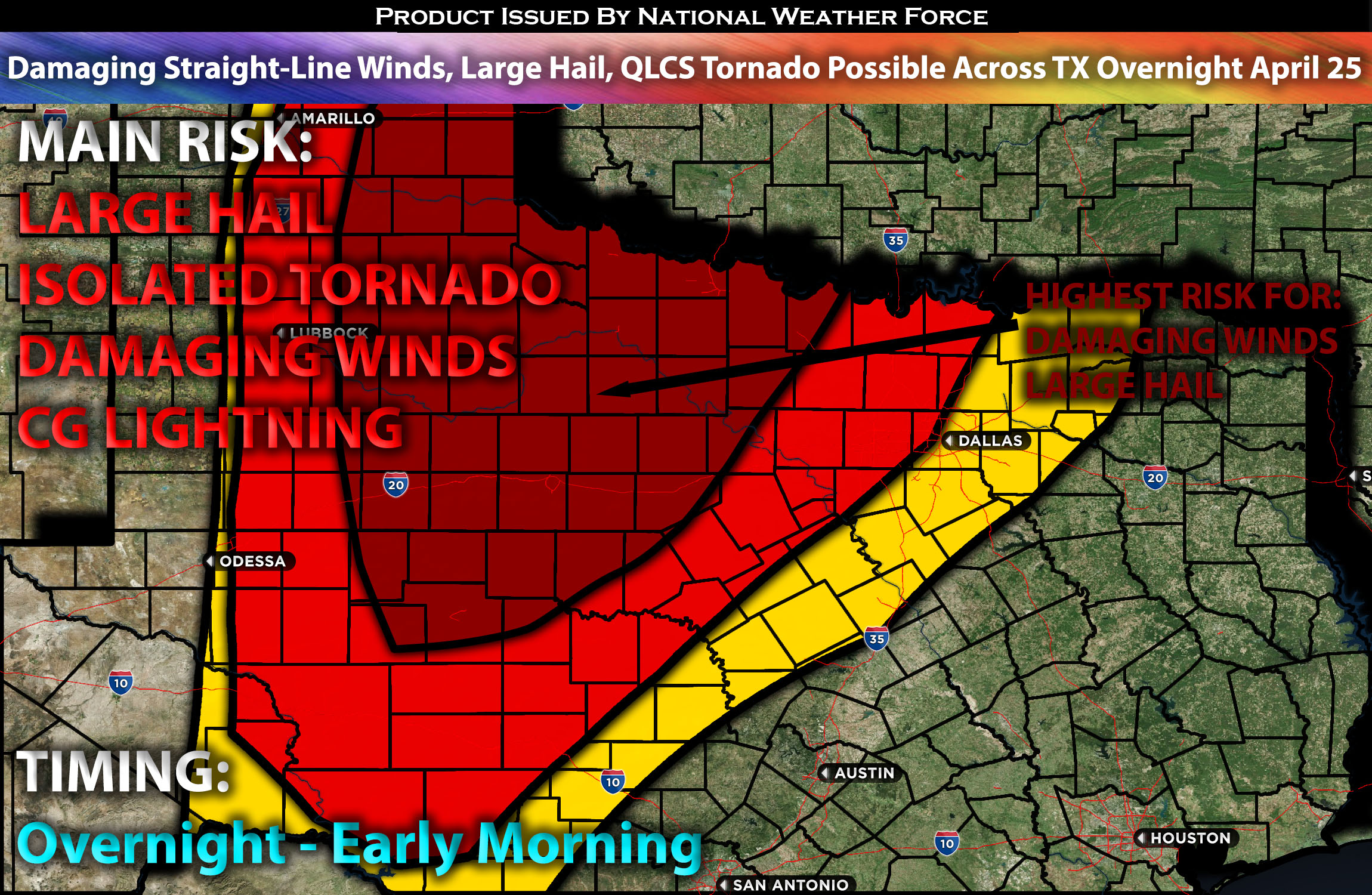
Overall Forecast for Portions of TX:
As a shortwave trough is set to move into the Plains, becoming increasingly negatively tilted and accompanied by strong mid-level flow spreading eastward into the central and southern Plains, setting the stage for severe weather. A dryline will extend southward, and a warm front will reach northeast Oklahoma by Thursday morning, advancing northward to cover Kansas by Friday. This configuration will establish a moist, buoyant warm sector conducive to severe thunderstorms.
Moderate southerly flow will facilitate moisture advection, raising dewpoints to the mid-60s across eastern Texas and enhancing vertical shear due to very steep mid-level lapse rates. Initial capping is expected to weaken, allowing for rapid storm development in a favorable environment. Given the storms’ proximity to one another, they are likely to be more linear due to immediate collision and downward instability. The main risks with these storms include damaging winds and potential QLCS tornadoes. Large hail is also possible with discrete cells, particularly with storms that remain separate.
Main Risk: large hail, damaging winds, isolated possible and CG lightning (cloud to ground).
Approximate Timing for Portions of TX: Once again, depending on when destabilization occurs, likely much later overnight on Thursday, a line of storms is anticipated to form from northwestern Texas into portions of the Texas Panhandle. These storms are expected to quickly strengthen as they move east towards the impacted regions. This line of storms will ride the northern area of Texas, bordering and extending into the southern portion of Oklahoma, and is expected to diminish early Friday morning.
Stay tuned for more updates.
Sina⚡⚡
With over a decade of experience in forecasting severe thunderstorms, this individual is a seasoned forecaster and developer. Their expertise in severe weather forecasting and computer science is entirely self-taught, complemented by a foundation in Atmospheric Science from UNCO and an IT background from WGU. They have dedicated their efforts to developing innovative tools that enhance the accuracy of analyzing large hail and tornadoes. As a significant contributor and partner at National Weather Force Innovations LLC, they have played a crucial role in providing accurate and timely information. Additionally, they have been instrumental in developing tools and organizing projects that focus on accuracy and performance, ensuring those affected are well-informed.