
Outlook:
Severe storms are expected from late Thursday afternoon into Thursday night as the atmosphere becomes very unstable across parts of the central and southern Plains. Very large hail, damaging winds, and tornadoes are possible. Please see below for further details, including timing, impact, and the risk area.
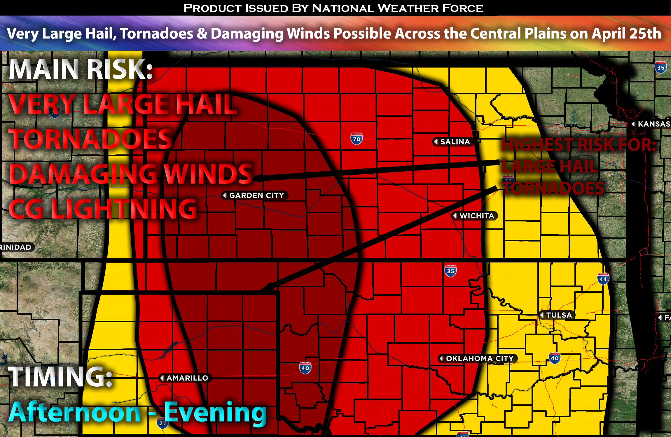
Overall Forecast for the Central Plains:
A shortwave trough is poised to move into the Plains, becoming increasingly negatively tilted as it progresses. Accompanying this will be a strong mid-level flow spreading eastward and northeastward into the central and southern Plains, effectively setting the stage for the main shortwave.
At the surface, cyclogenesis is anticipated ahead of the trough across the central High Plains. The resulting surface low is forecasted to move northeastward into western Kansas and southwest Nebraska by late Thursday night into early Friday morning. A dryline will extend southward from this system throughout most of the period, and a warm front will stretch east-southeastward from the low, reaching northeast Oklahoma by Thursday morning. This warm front is expected to move northward throughout the day, covering much of Kansas by early Friday. This setup will establish a moist and buoyant warm sector south of the front, creating an environment ripe for strong to severe thunderstorms as they interact with the shortwave.
Moisture advection, facilitated by moderate low-level southerly flow in anticipation of the approaching shortwave trough, will raise dewpoints to the mid-60s by mid-afternoon across eastern Texas, the Oklahoma Panhandle, and Oklahoma, with low 60s dewpoints extending into south-central Kansas over time. By early evening, mid-60s dewpoints are projected to dominate in western and south-central Kansas. Supported by very steep mid-level lapse rates, these conditions will encourage moderate to strong buoyancy. Additionally, the strengthening mid-level flow will amplify deep vertical shear. While some capping may initially inhibit storm development, it is expected to weaken, significantly increasing the likelihood of rapid storm formation under favorable conditions.
Highest Tornado Risk Region: As the evening progresses, low-level shear is expected to increase for a certain period, which could allow any long-lived and strong supercells to potentially produce a few tornadoes, possibly even a strong one, if the right ingredients and timing align across west central/southwest Kansas.
Main Risk: extremely large hail, damaging winds, tornadoes perhaps a strong one and CG lightning (cloud to ground).
Approximate Timing for KS/OK/NE: Depending on when destabilizations occurs and when/where the cap breaks storms are expected to explode across the area. The timing looks to be around the late afternoon/evening and quickly strengthening capable of all hazard types mentioned earlier continuing to move northeastward before diminishing overnight as they move into more stable airmass northeastward.
Stay tuned for more updates.
Sina⚡⚡
With over a decade of experience in forecasting severe thunderstorms, this individual is a seasoned forecaster and developer. Their expertise in severe weather forecasting and computer science is entirely self-taught, complemented by a foundation in Atmospheric Science from UNCO and an IT background from WGU. They have dedicated their efforts to developing innovative tools that enhance the accuracy of analyzing large hail and tornadoes. As a significant contributor and partner at National Weather Force Innovations LLC, they have played a crucial role in providing accurate and timely information. Additionally, they have been instrumental in developing tools and organizing projects that focus on accuracy and performance, ensuring those affected are well-informed.