
Outlook:
Severe storms are expected with a possible outbreak for Saturday into Saturday night, particularly concentrated in the central and southern Plains. These storms are capable of producing very large hail, damaging winds, and multiple strong, potentially violent tornadoes if discrete modes are maintained. Please see below for further details, including timing, impact, and the risk area.
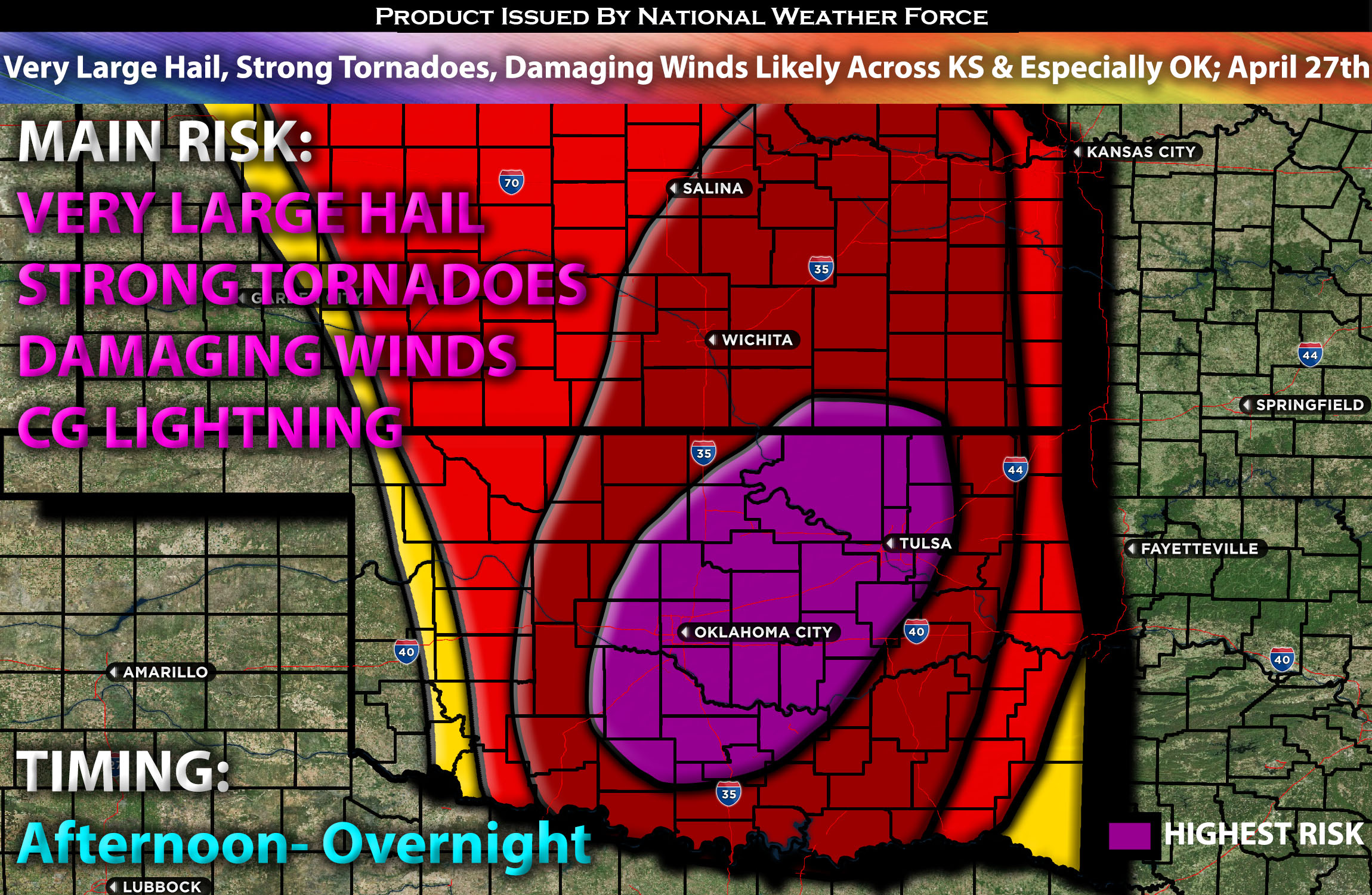
Overall Forecast for Southern/Central Plains (Concentrated on OK/KS):
The current shortwave trough causing a widespread tornado outbreak will gradually weaken as it moves across the Great Lakes. Concurrently, the associated surface low will also diminish. Meanwhile, another significant upper trough from the Southwest will progress across the central Plains, accompanied by a 60-70 knot southwesterly mid-level jet affecting the same regions. Surface cyclogenesis is anticipated over western Kansas by Saturday afternoon, with the low expected to move towards central Kansas by Saturday night. A dryline will stretch southward from this low across the southern and central High Plains, while a warm front will extend northeastward from the low, reaching into the central Plains and Upper Midwest.
Ongoing storm development is expected across Oklahoma starting Saturday morning, driven by ascent along a retreating dryline and moisture advection from a southerly low-level jet. Steep lapse rates aloft will foster moderate to strong instability, contributing to the potential for large hail. Later in the day, substantial destabilization is anticipated along and east of the dryline, and south of the warm front. This environment, characterized by very strong instability and extreme effective shear, along with significant low-level updrafts, is likely to support multiple supercell formations along the dryline and warm front. With 50 knots of deep-layer shear, these storms are expected to organize quickly, and very strong low-level shear will enable them to become rotational, capable of producing very large potentially destructive hail, several strong or violent tornadoes possible, and widespread damaging winds.
Depending on how long discrete mode can maintain will be a big factor on how big the outbreak will be as well. As these storms collide and become a line with a greater threat for destructive damaging winds emerges with a QLCS as all storms merge overnight and continue eastward. There will also be a risk for QLCS tornadoes given the dynamics.
Main Risk: very large hail, tornadoes a few strong/violent possible, damaging winds and CG lightning (cloud to ground).
Approximate Timing: Depending on when destabilization occurs, which appears likely to be significant across Oklahoma and eastern Kansas in the afternoon and late afternoon, storms are expected to form east and along the dryline and rapidly mature. If they remain in discrete mode, these storms could significantly impact the affected regions as they move northeastward, with tornadoes and large hail as the initial main risks. Eventually, they are likely to merge later overnight into early Sunday morning, sweeping eastward across eastern Oklahoma and parts of the Ozarks as a QLCS.
Highest Tornado Risk Region: The highest concentration of tornadoes is expected across central and eastern Oklahoma, where factors such as the low-level jet and shear will be most conducive for tornado development. This could possibly include a few strong or violent tornadoes, particularly during the afternoon and peaking in the evening hours.

Stay tuned for more updates.
Sina⚡⚡
With over a decade of experience in forecasting severe thunderstorms, this individual is a seasoned forecaster and developer. Their expertise in severe weather forecasting and computer science is entirely self-taught, complemented by a foundation in Atmospheric Science from UNCO and an IT background from WGU. They have dedicated their efforts to developing innovative tools that enhance the accuracy of analyzing large hail and tornadoes. As a significant contributor and partner at National Weather Force Innovations LLC, they have played a crucial role in providing accurate and timely information. Additionally, they have been instrumental in developing tools and organizing projects that focus on accuracy and performance, ensuring those affected are well-informed.