
 Outlook:
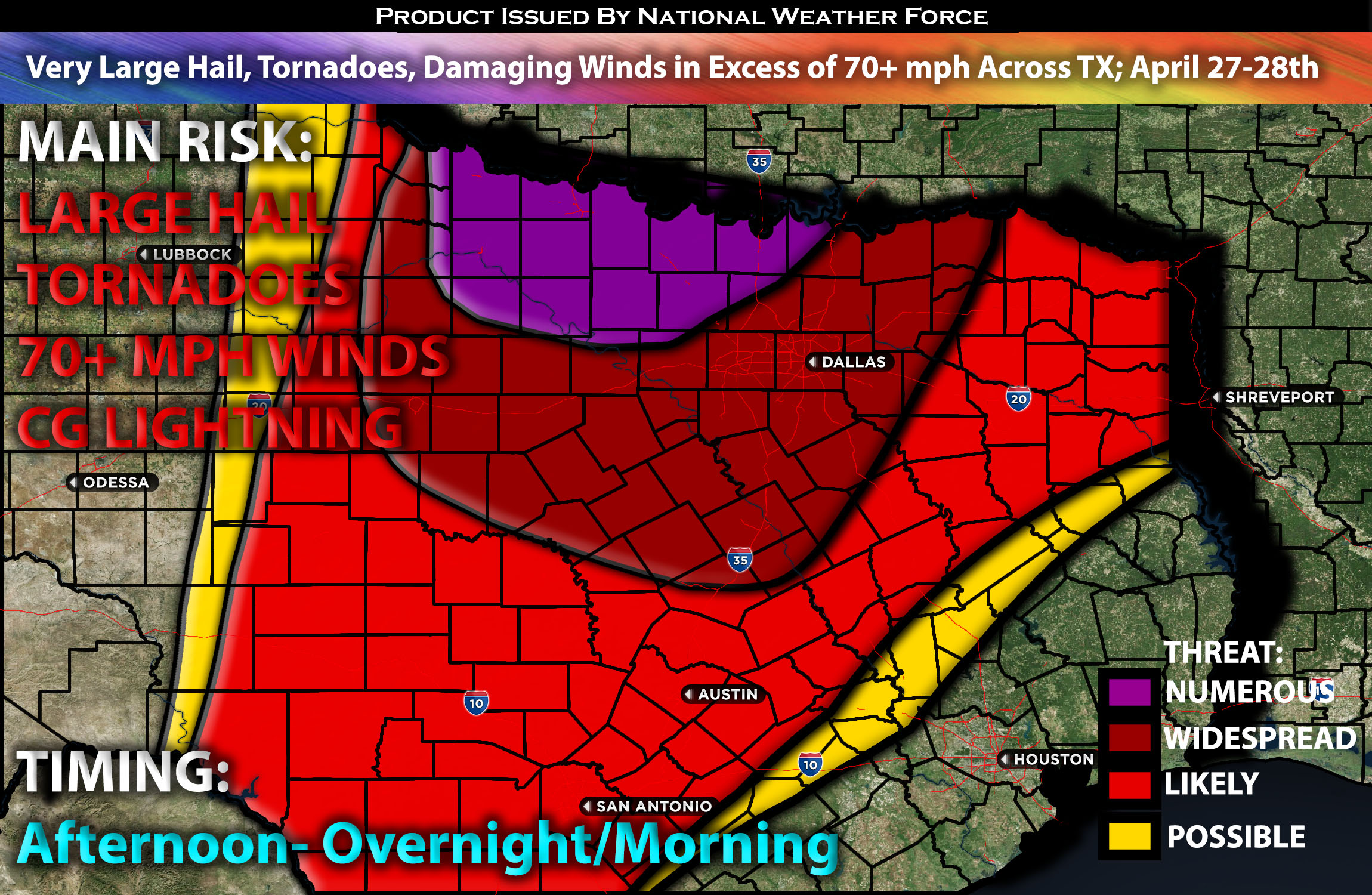
Severe storms with a potential outbreak are expected from Saturday into Saturday night across Texas, particularly northern Texas. These storms may produce very large hail, damaging winds, and tornadoes. The risk includes tornadoes from discrete storm cells and those associated with quasi-linear convective systems (QLCS). Please see below for further details, including timing, impact, and the risk area.
Overall Forecast for Portions of TX:
Today, an upper-level trough will traverse the Desert Southwest, propelled by an 80-knot mid-level jet moving swiftly eastward. Ahead of this trough, a moist and unstable airmass will cover the southern and central Plains. At the surface, a low will track eastward across southwest Kansas, with a dryline stretching south through far western Oklahoma and west Texas, which will be the focus of this forecast. To the east of this dryline, surface dewpoints will reach the mid to upper 60s°F.
Warm advection this morning is likely to trigger a cluster of thunderstorms east of the dryline in northwest Texas. These storms are expected to produce large hail and wind damage, with very large hail—hailstones over 2 inches in diameter—possible in the more intense storms. By evening, a line of severe storms is expected to develop, moving eastward across northern Texas. This line could bring wind gusts exceeding 70 mph and potentially QLCS tornadoes with any rotating cells embedded within, persisting into the overnight and early morning hours.
Main Risk: very large hail, tornadoes, damaging winds potentially over 70+ mph and CG lightning (cloud to ground).
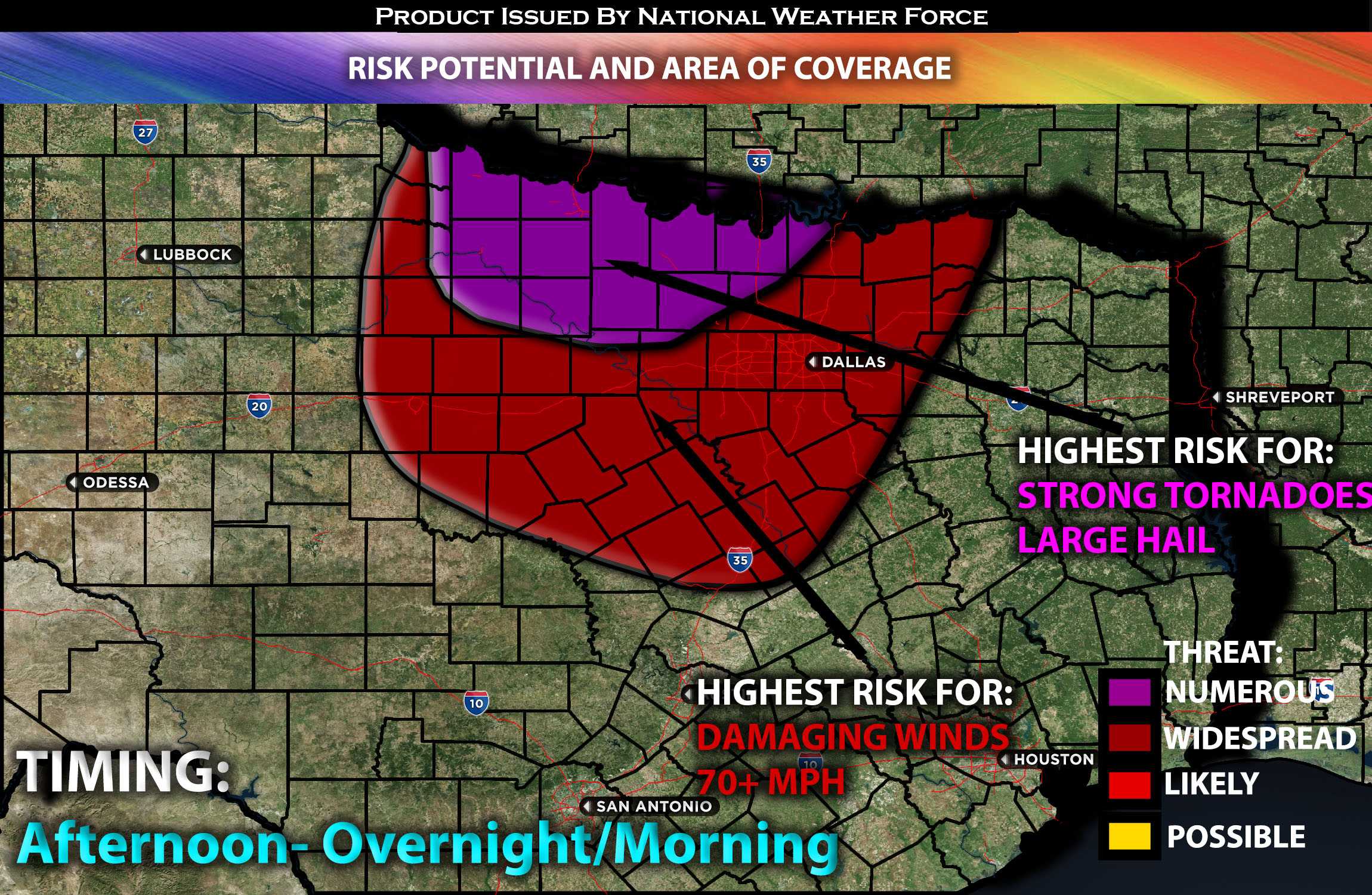
Approximate Timing: Depending on when destabilization occurs, storms are expected to form in the late afternoon, particularly into the evening, starting from northwestern Texas near the Oklahoma border and increasing in coverage. Initially, these storms may be more discrete. Later overnight, additional storms will form and merge as they move east across northern Texas, including the Dallas area, by early morning. These storms are likely to bring potentially destructive winds exceeding 70 mph, along with possible QLCS tornadoes, and will continue to push east before diminishing in the morning hours of Sunday. They may potentially re-strengthen later (for more on this, see the next forecast update).
Stay tuned for more updates.
Sina⚡⚡
With over a decade of experience in forecasting severe thunderstorms, this individual is a seasoned forecaster and developer. Their expertise in severe weather forecasting and computer science is entirely self-taught, complemented by a foundation in Atmospheric Science from UNCO and an IT background from WGU. They have dedicated their efforts to developing innovative tools that enhance the accuracy of analyzing large hail and tornadoes. As a significant contributor and partner at National Weather Force Innovations LLC, they have played a crucial role in providing accurate and timely information. Additionally, they have been instrumental in developing tools and organizing projects that focus on accuracy and performance, ensuring those affected are well-informed.