
Outlook:
Several severe storms are possible across parts of the central and southern Great Plains from Wednesday afternoon into Wednesday night. A few tornadoes, very large hail, and damaging winds are possible given the ingredients present. Check below for the details on timing, impact and much more.
Overall Forecast:
A robust shortwave trough, accompanied by impulses, is moving across the Upper Great Lakes and will gradually shift east from the northern Rockies to the northern High Plains. Concurrently, a cold front over the central Great Plains will stall and subsequently lift north as a warm front on Wednesday night. This situation involves stationary fronts located in southern Kansas. The dryline, positioned from southwest to west-central Kansas, is likely to present the most favorable combination of thermodynamic and kinematic conditions. Despite near-neutral mid-level height changes through the early evening, convergence along the dryline will be crucial for initiating late afternoon thunderstorms.
Across the Central Great Plains:
Expect very strong instability across a somewhat uncapped and highly unstable region across KS southern portions especially, supplemented by effective deep-layer shear and some low-level shear. However, storm coverage is likely to remain isolated due to the lack of consistent ingredients. Nonetheless, within this highly favorable localized environment, there is a significant risk for supercells, tornadoes, and very large hail for a short period of time.
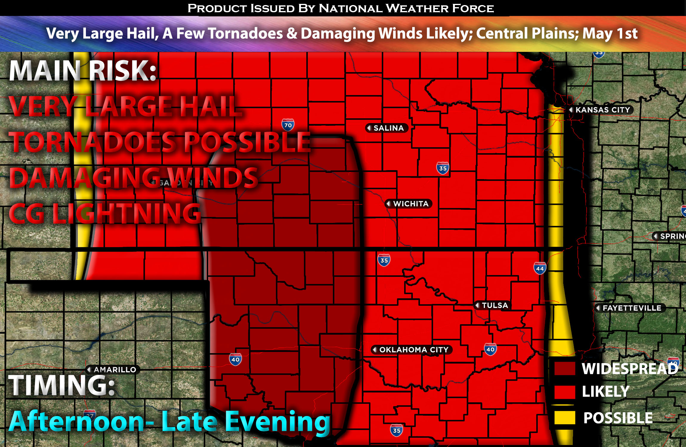
Main Risk: very large hail, tornadoes possible if ingredients align), damaging winds and CG lightning (cloud to ground).
Approximate Timing: Depending on when destabilization occurs, which in this case is expected to be very explosive due to the low cap and highly unstable airmass, storms are anticipated to form around late afternoon in KS mainly south into the evening and continue eastward over time, capable of producing all types of hazards.
Stay tuned for more updates.
Sina⚡⚡
With over a decade of experience in forecasting severe thunderstorms, this individual is a seasoned forecaster and developer. Their expertise in severe weather forecasting and computer science is entirely self-taught, complemented by a foundation in Atmospheric Science from UNCO and an IT background from WGU. They have dedicated their efforts to developing innovative tools that enhance the accuracy of analyzing large hail and tornadoes. As a significant contributor and partner at National Weather Force Innovations LLC, they have played a crucial role in providing accurate and timely information. Additionally, they have been instrumental in developing tools and organizing projects that focus on accuracy and performance, ensuring those affected are well-informed.