
 Outlook:
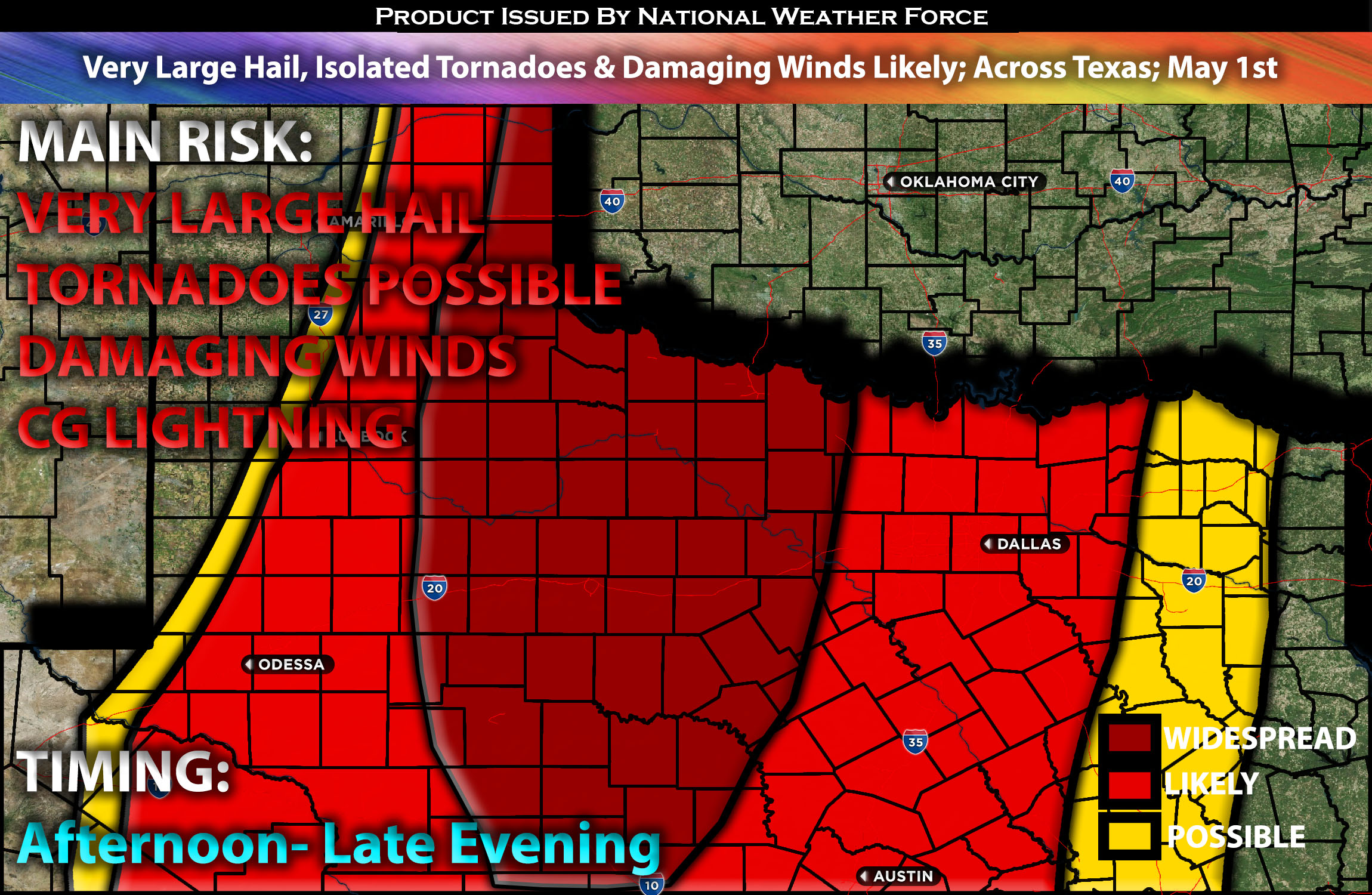
Several severe storms are likely across parts of Texas from Wednesday afternoon into Wednesday night. A few tornadoes, very large hail, and damaging winds are possible given the ingredients present in that area. Check below for the details on timing, impact and much more.
Overall Forecast:
An upper-level trough will traverse the region, maintaining southwesterly mid-level flow over the southern and central Plains. At the surface, a low-pressure system is expected to intensify over southeast Colorado, while a warm front moves northward across central and north-central Kansas. Additionally, a dryline will extend from southwest Kansas southward into west Texas. Abundant moisture, with surface dewpoints ranging from the mid to upper 60s F, will spread eastward from the dryline across much of the southern Plains. This moisture, combined with deep effective shear, strong instability, and low-level shear, will create conditions conducive to all types of severe weather.
Across Texas:
In the Texas Panhandle bordering Oklahoma, super cellular storms are anticipated due to the favorable ingredients, capable of producing all types of severe weather in a semi-discrete setup. Further south, across northwest and west-central Texas, a linear Mesoscale Convective System (MCS) is expected to form given the linear storm setup. Mixed layer instability to the east of the dryline is expected to be very strong with very strong mid-level lapse rates. This, coupled with deep effective shear in the 30 knots, may support discrete rotating storms capable of all hazards, especially very large hail up to 2-3 inches. However, a transition to a linear mode is expected later in the afternoon. This linear MCS may produce severe wind damage along its leading edge.
Main Risk: very large hail, isolated tornadoes possible if ingredients align), damaging winds and CG lightning (cloud to ground).
Approximate Timing: Depending on the timing of destabilization and storm initiation, storms are expected to begin developing along the dryline in the afternoon and increase in coverage into the late afternoon and evening. Initially, these storms may be somewhat semi-discrete before merging and forming a line, eventually transitioning into a Mesoscale Convective System (MCS) by late afternoon.
Stay tuned for more updates.
Sina⚡⚡
With over a decade of experience in forecasting severe thunderstorms, this individual is a seasoned forecaster and developer. Their expertise in severe weather forecasting and computer science is entirely self-taught, complemented by a foundation in Atmospheric Science from UNCO and an IT background from WGU. They have dedicated their efforts to developing innovative tools that enhance the accuracy of analyzing large hail and tornadoes. As a significant contributor and partner at National Weather Force Innovations LLC, they have played a crucial role in providing accurate and timely information. Additionally, they have been instrumental in developing tools and organizing projects that focus on accuracy and performance, ensuring those affected are well-informed.