
 Outlook:
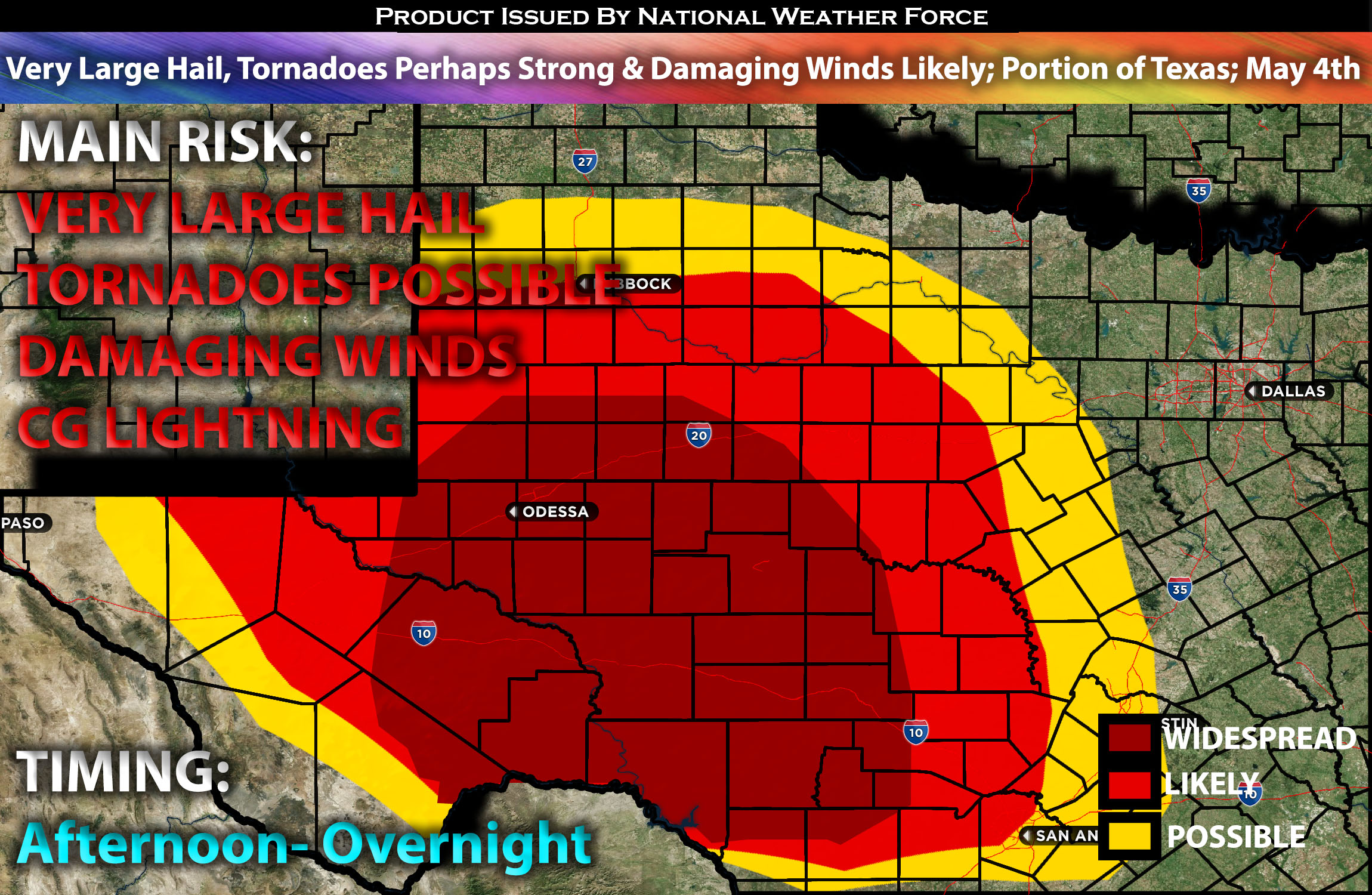
Scattered severe storms are anticipated to form across parts of western and central Texas this afternoon and evening. Several storms may produce very large hail, and perhaps a strong tornado if the right ingredients align. Check below for the details on timing, impact and much more.
Overall Forecast:
It is anticipated that a shortwave trough will advance, with a 500mb speed maximum reaching central Texas by this afternoon. Concurrently, strong boundary-layer heating is expected ahead of the wind shift across far west Texas into portions of central Texas, where a front will be situated.
Across Western/Central Texas:
Across Texas, the dryline will be forced deep into west Texas, serving as a specific area for convective development alongside the cold front. This, combined with mixed-layer instability ranging from very strong to extreme levels of 3500 J/kg and deep effective bulk shear around 45kt, is conducive to scattered supercells developing by mid-afternoon, quickly intensifying into severe storms. As this activity grows upscale and shifts downstream, aided by the progressive shortwave, a low-level jet (LLJ) is expected to focus across west Texas through early evening before strengthening and shifting east toward the I-35 corridor by sunrise Sunday. Initially, the convective mode will be super cellular, with the potential for very large hail given the high instability levels. Furthermore, a moistening boundary layer will support tornadoes, possibly strong, due to the strong low-level shear with the right ingredients in place for a time period. Eventually, these storms will converge and form a Mesoscale Convective System (MCS) as they continue to move into central Texas throughout the night and into the early morning hours.
Main Risk: very large hail, tornadoes perhaps a strong one (if ingredients align), damaging winds and CG lightning (cloud to ground).
Stay tuned for more updates.
Sina⚡⚡
With over a decade of experience in forecasting severe thunderstorms, this individual is a seasoned forecaster and developer. Their expertise in severe weather forecasting and computer science is entirely self-taught, complemented by a foundation in Atmospheric Science from UNCO and an IT background from WGU. They have dedicated their efforts to developing innovative tools that enhance the accuracy of analyzing large hail and tornadoes. As a significant contributor and partner at National Weather Force Innovations LLC, they have played a crucial role in providing accurate and timely information. Additionally, they have been instrumental in developing tools and organizing projects that focus on accuracy and performance, ensuring those affected are well-informed.