
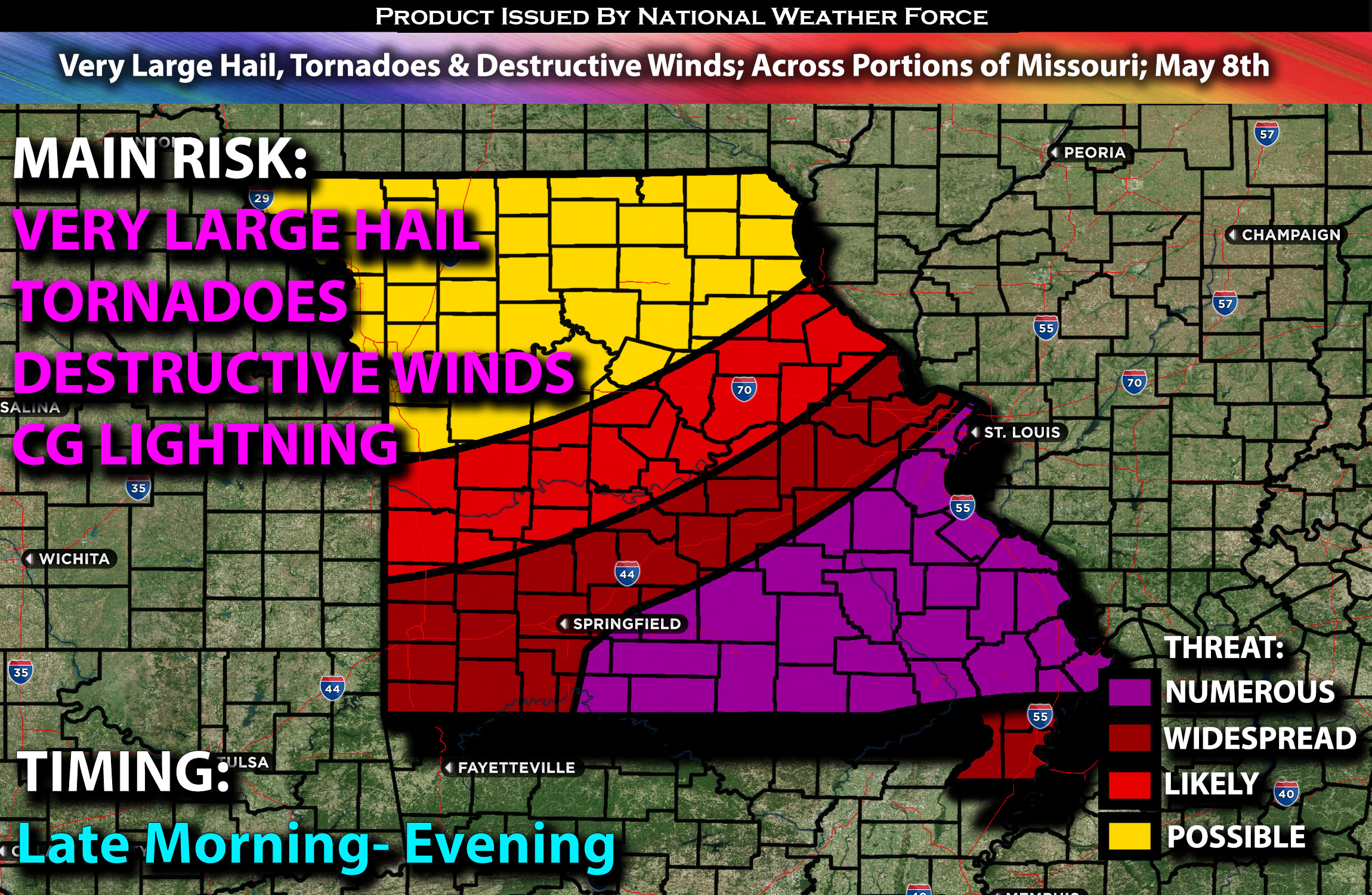
Outlook:
Wednesday is expected to bring severe storms to area of Missouri especially southeast. All severe weather threats, such as tornadoes, very large to giant hail, and potentially significant damaging winds, are possible. Some of the tornadoes could be strong. For detailed information on timing, impacts, and more, refer below.
Overall Forecast:
An upper-level low is expected to shift eastward from the north-central Plains into the upper Mississippi Valley, while another mid/upper-level low is predicted to form within the trailing segment of the upper trough across the Great Basin. Positioned to the south of the midlevel low in the Great Plains, an embedded shortwave trough and accompanying jet maximum will migrate from the central Plains toward the mid-Mississippi Valley. Meanwhile, farther northeast, a shortwave trough and associated surface low will progress from the upper Great Lakes region into the Northeast.
Across Missouri Especially the Southeast:
Very strong deep-layer shear, combined with extreme instability and low-level shear, will intensify these storms significantly as they develop. There is a possibility that a Mesoscale Convective System (MCS), forming as a powerful line, could track east southeastward. If this scenario unfolds, a swath of damaging winds could extend towards the Tennessee and lower Ohio Valleys. Additionally, there’s a risk of tornadoes embedded within the line of storms, along with very large hail accompanying each storm. These storms are expected to initiate across central Missouri and concentrate into southeastern/eastern Missouri, where the most concentrated ingredients will be present.
These supercells, primarily occurring in clusters, are anticipated to bring the potential for large to very large hail and damaging winds. Isolated gusts exceeding 75+ mph could occur, which would be highly destructive.
Coverage Details:
Storms are expected to begin as clusters, initially appearing as discrete entities before likely evolving into a more linear structure and bowing out from morning through evening in multiple waves. These storms will be severe, fueled by an extremely unstable air mass, and capable of producing various hazards, notably very damaging winds, large hail, and tornadoes.
Future Radar Scenario:
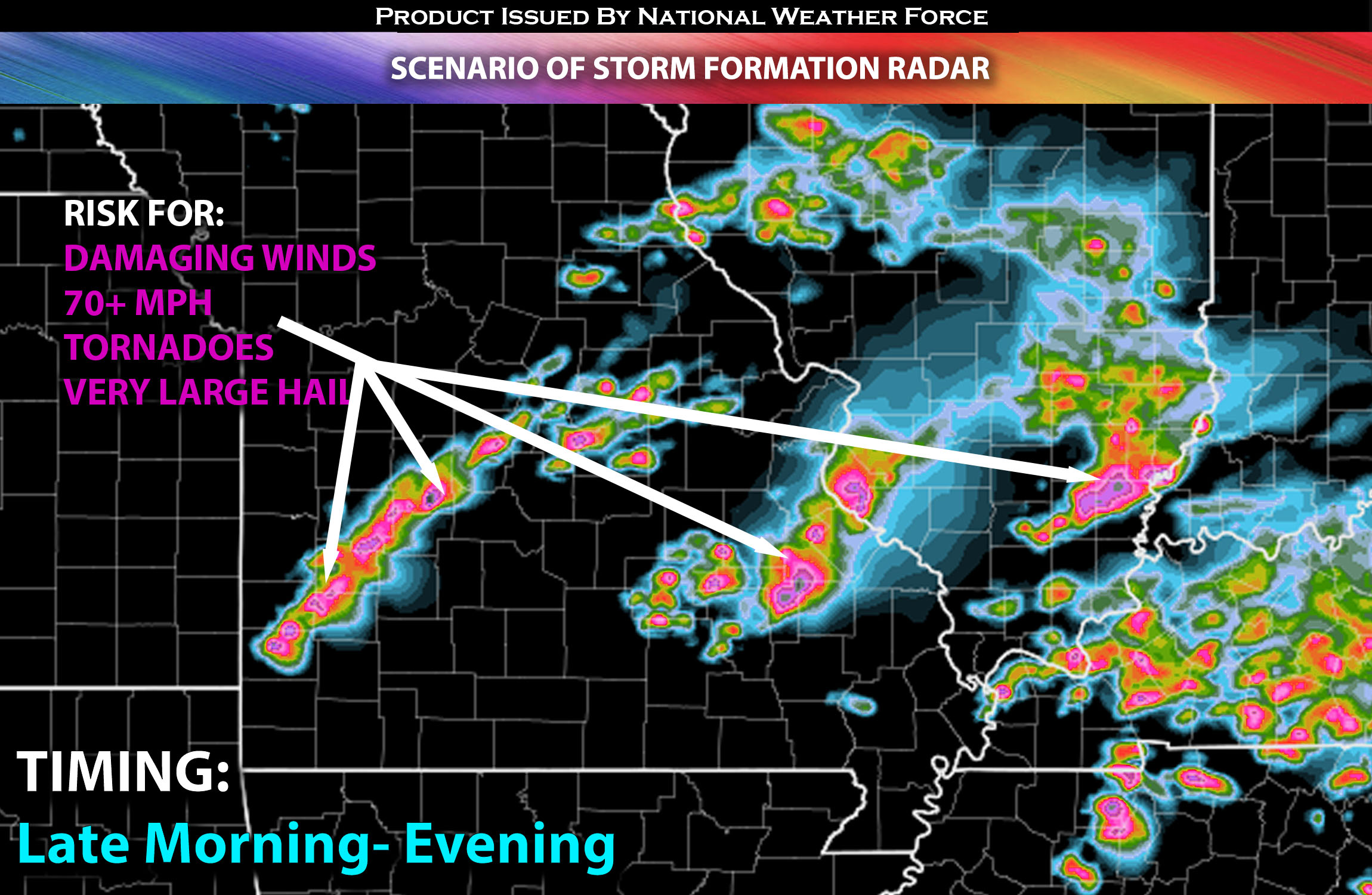
Main Risk: very large hail, tornadoes a strong one possible (if ingredients align), destructive winds and CG lightning (cloud to ground).
Stay tuned for more updates.
Sina⚡⚡
With over a decade of experience in forecasting severe thunderstorms, this individual is a seasoned forecaster and developer. Their expertise in severe weather forecasting and computer science is entirely self-taught, complemented by a foundation in Atmospheric Science from UNCO and an IT background from WGU. They have dedicated their efforts to developing innovative tools that enhance the accuracy of analyzing large hail and tornadoes. As a significant contributor and partner at National Weather Force Innovations LLC, they have played a crucial role in providing accurate and timely information. Additionally, they have been instrumental in developing tools and organizing projects that focus on accuracy and performance, ensuring those affected are well-informed.