
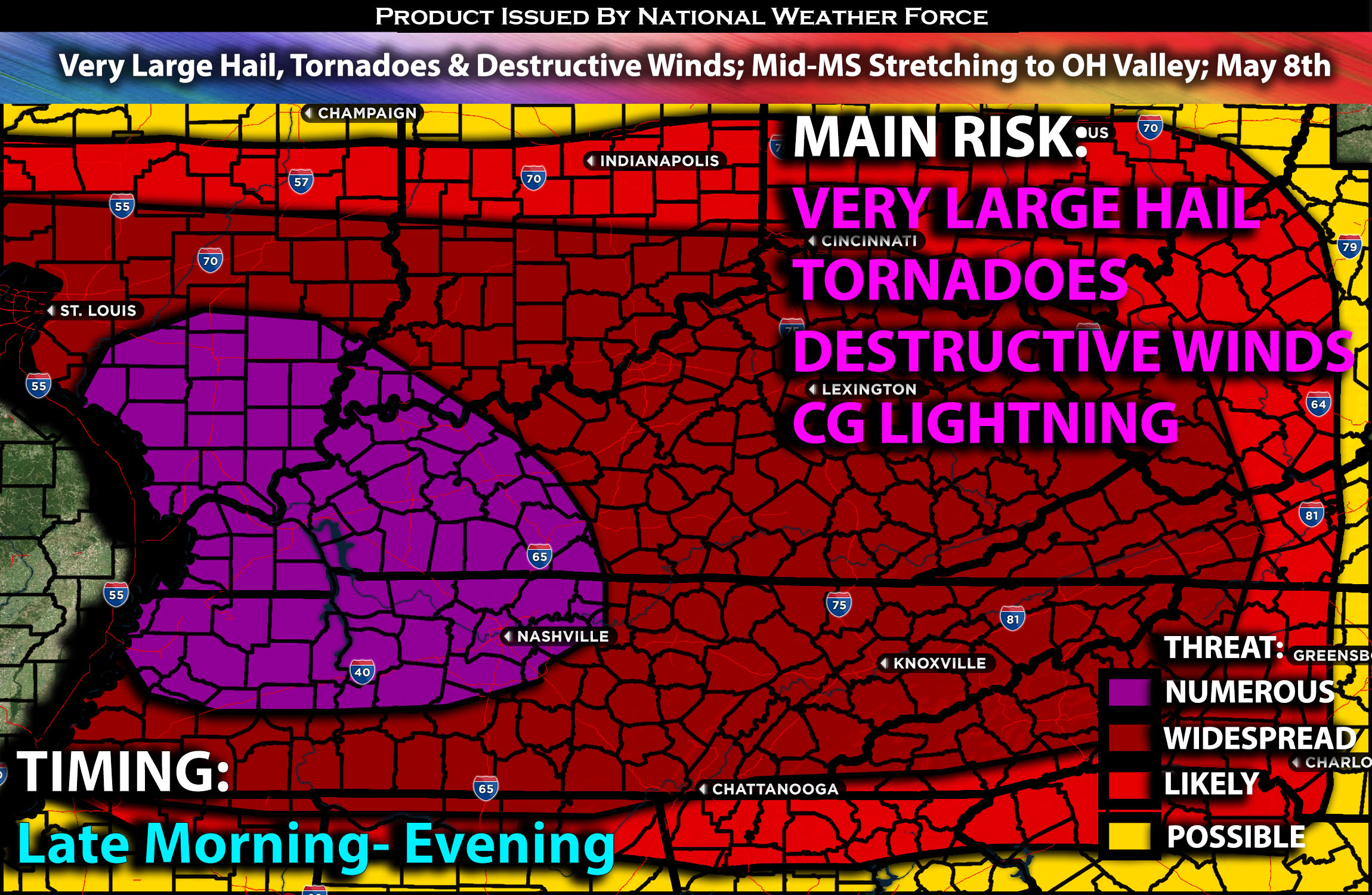
Outlook:
Wednesday is expected to bring severe storms to areas spanning from the mid Mississippi to the Ohio and Tennessee Valleys. All severe weather threats, such as tornadoes, very large to giant hail, and potentially significant damaging winds, are possible. Some of the tornadoes could be strong. For detailed information on timing, impacts, and more, refer below.
Overall Forecast:
As the upper shortwave trough currently positioned over the Lower Great Lakes gradually shifts eastward/northeastward across the Northeastern U.S., it will maintain a broad expanse of 65 kt southwesterly mid-level to upper-level flow extending from the central Plains to the Midwest/Mid-South and Northeast. This extensive region of heightened atmospheric flow will overlay a notably moist boundary-layer, resulting in a strongly sheared environment, characterized by winds shifting with height. Large-scale ascent is anticipated to be somewhat limited or indistinct throughout the day, with mesoscale features or ascent potentially exerting a more pronounced influence on storm development and evolution. Therefore, widespread thunderstorms are expected to form in due course.
Across the Ohio Valley & TN Valley:
At the surface, a low-pressure system is expected to reside over the Ohio Valley with a cold front extending to the south of it. The positioning of the warm front ahead of it will also play a significant role in the severity of the weather. Warm air advection is forecasted ahead of the cold front, with very strong instability and steep mid-lapse rates expected. Coupled with very strong deep effective layer shear and low-level shear, these conditions will enable storms to be capable of producing all types of severe weather. Particularly, these storms are likely to generate very large hail, ranging from 2 to 3 inches easily, and tornadoes, with the potential for a strong tornado if the ingredients align. Damaging winds will also pose a risk, especially as storms bow out overnight.
Coverage Details:
Storms are anticipated to initially form in clusters, starting as more discrete entities before likely transitioning to a more linear structure and bowing out from the morning through the evening hours in multiple waves. These storms will be severe in nature due to the extremely unstable air mass, capable of producing all types of hazards, particularly very damaging winds, large hail, and tornadoes.
Future Radar Scenario:
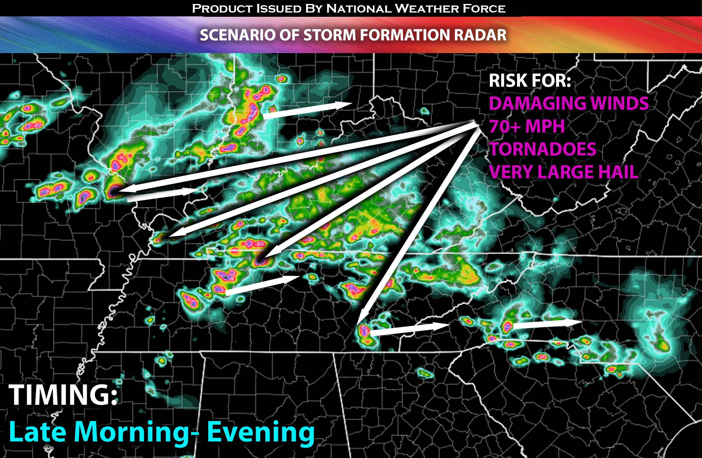
Main Risk: very large hail, tornadoes a strong one possible (if ingredients align), destructive winds and CG lightning (cloud to ground).
Stay tuned for more updates.
Sina⚡⚡
With over a decade of experience in forecasting severe thunderstorms, this individual is a seasoned forecaster and developer. Their expertise in severe weather forecasting and computer science is entirely self-taught, complemented by a foundation in Atmospheric Science from UNCO and an IT background from WGU. They have dedicated their efforts to developing innovative tools that enhance the accuracy of analyzing large hail and tornadoes. As a significant contributor and partner at National Weather Force Innovations LLC, they have played a crucial role in providing accurate and timely information. Additionally, they have been instrumental in developing tools and organizing projects that focus on accuracy and performance, ensuring those affected are well-informed.