
 Outlook:
A line of severe storms, known as a Quasi-Linear Convective System (QLCS), is expected to form and move southeastward, sweeping through portions of the Deep South, primarily southward on Monday from the morning into the evening hours. These storms will be capable of producing damaging straight-line winds and embedded tornadoes if the ingredients align.
Overall Forecast:
A shortwave trough originating from the central Plains is forecasted to progress eastward, reaching the lower Mississippi Valley by the early hours of Tuesday, while an upper high remains centered over the islands of Cuba. As this trough advances eastward, heights across the region will gradually decrease, leading to a gradual flattening of the ridge along the Gulf Coast. Midlevel winds of around 60 knots will be prevalent, with even stronger flow reaching around 80 knots at higher altitudes, shifting northeastward along with the shortwave trough, providing favorable conditions for thunderstorm development.
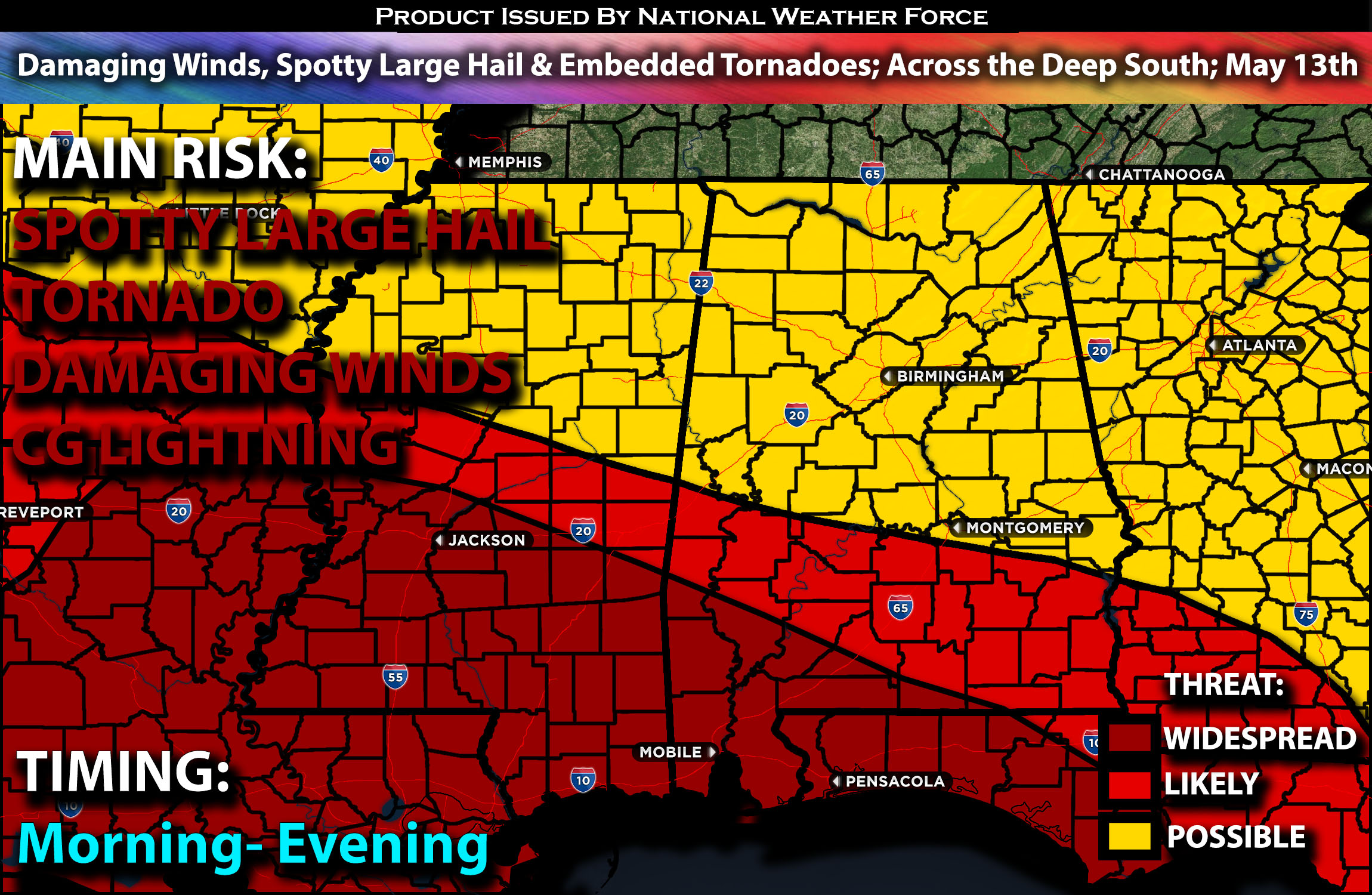
Across the Deep South:
At the surface, a weak low-pressure system is expected to develop from northern Missouri southward across the ArkLaTex region. A highly moist air mass will prevail across the lower Mississippi Valley, with moisture levels increasing late in the period across southern Alabama, Georgia, and Florida as a warm front lifts northward. The abundant moisture content will lead to widespread cloud cover and precipitation throughout the area over time. However, this significant moisture may impose some limitations on the severity of the storms, as the air mass could become slightly less unstable.
Simultaneously, efficient to strong instability is projected to extend over the central Gulf Coast during the day, beneath moderate westerly winds aloft, which will enhance deep-layer shear. Stronger low-level shear will primarily be concentrated in the warm front area, spanning from Alabama into Georgia and northern Florida. An MCS is anticipated to be also on going which is another complexity to watch as well. There are some suggestions of another MCS to sweep the deep south into the evening/overnight hours as well. These storms have the potential to produce large hail, damaging winds, and isolated tornadoes mostly embedded.
Coverage Details:
An ongoing Mesoscale Convective System (MCS) is expected to move through Alabama into the morning and afternoon hours of Monday, progressing eastward and capable of generating damaging straight-line winds and potentially embedded QLCS tornadoes. Following this, more scattered storms are anticipated to form, capable of producing all types of hazards, although to a lesser extent due to the inefficiency of ingredients. This QLCS line is projected to mostly move south southeastward across the Deep South toward the Gulf Coast in a sweeping motion through the evening, reaching northern Florida.
Future Radar Scenario:
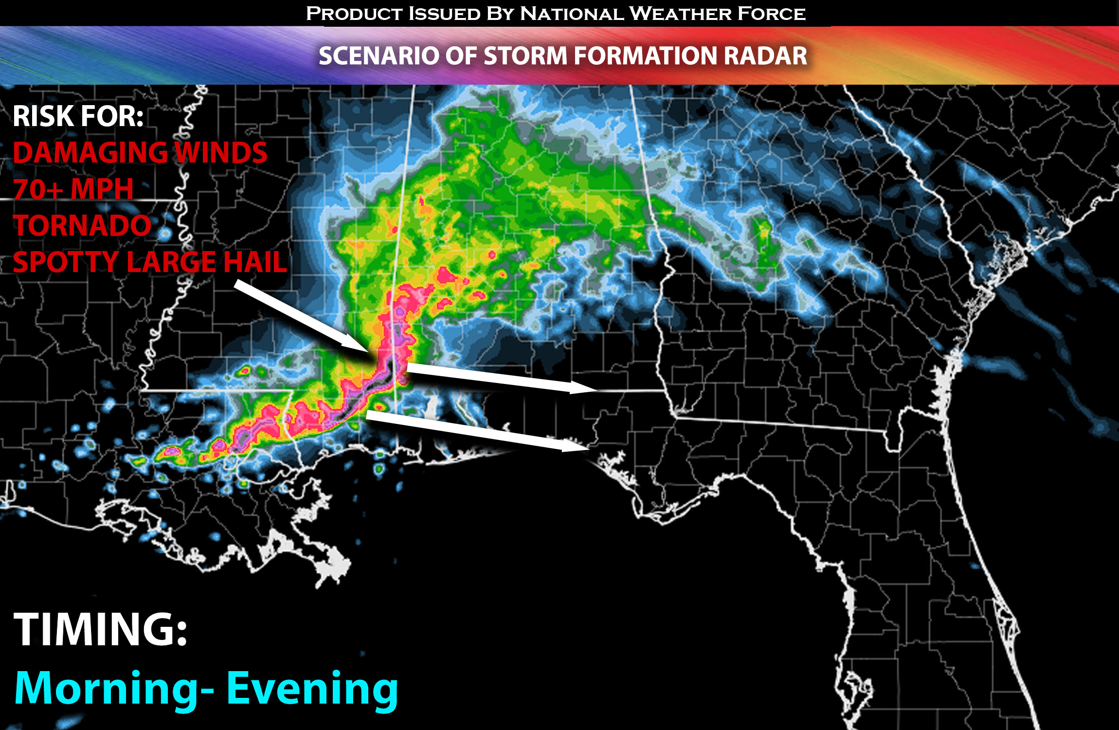
Main Risk: large hail possible, embedded tornadoes (if ingredients align), damaging winds and CG lightning (cloud to ground).
Stay tuned for more updates.
Sina⚡⚡
With over a decade of experience in forecasting severe thunderstorms, this individual is a seasoned forecaster and developer. Their expertise in severe weather forecasting and computer science is entirely self-taught, complemented by a foundation in Atmospheric Science from UNCO and an IT background from WGU. They have dedicated their efforts to developing innovative tools that enhance the accuracy of analyzing large hail and tornadoes. As a significant contributor and partner at National Weather Force Innovations LLC, they have played a crucial role in providing accurate and timely information. Additionally, they have been instrumental in developing tools and organizing projects that focus on accuracy and performance, ensuring those affected are well-informed.