
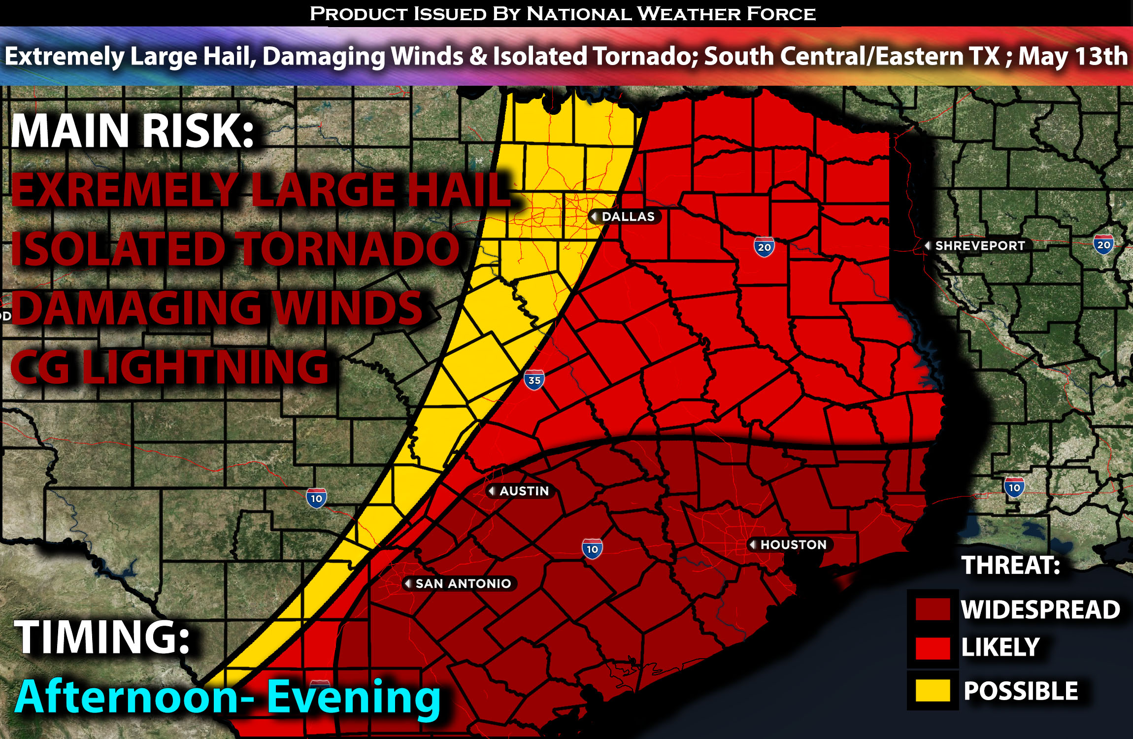
Outlook:
Severe storms, capable of producing extremely large hail, especially before clustering into a line, are expected to impact the central/southern and eastern Texas area on Monday. Eventually, the main threat will transition towards damaging winds. For detailed information on timing, impacts, and more, refer below.
Overall Forecast:
The same shortwave trough originating from the central Plains is expected to move eastward, reaching the lower Mississippi Valley by the early hours of Tuesday, while an upper high remains centered over the islands of Cuba. As this trough progresses eastward, heights across the region will gradually decrease, resulting in a gradual flattening of the ridge along the Gulf Coast. Midlevel winds of approximately 60 knots will be widespread, with even stronger flow reaching up to 80 knots at higher altitudes, shifting northeastward alongside the shortwave trough. These conditions create favorable circumstances for thunderstorm development.
Across the Central and Eastern TX:
With clearing skies, extreme mid-level lapse rates are anticipated to combine with a moist boundary layer. While cloud cover may somewhat limit diurnal heating, temperatures are forecasted to exceed 80°F, fostering 3000-4000 J/kg of instability with the given dewpoints and lapse rates. Simultaneously, a band of stronger mid-level flow will spread across the region, promoting the development of splitting supercells, particularly in the early stages. These storms pose a significant threat of extremely large hail, with some stones potentially reaching 3-4 inches in diameter, especially within sustained supercell structures.
As the evening unfolds, storms are projected to consolidate into a Mesoscale Convective System (MCS) later in the afternoon/evening, benefiting from more favorable interactions with the baroclinic boundary. At this point, severe gusts become the primary concern, with a few QLCS tornadoes potentially embedded within the line of storms.
Coverage Details:
In the afternoon, as destabilization occurs, storms are expected to erupt across central and eastern Texas, forming into supercells. The primary risk associated with these storms will be extremely large hail, which could easily exceed 3 inches in diameter. These storms will continue to move eastward and increase in coverage, particularly across eastern Texas, eventually clustering together and forming a Mesoscale Convective System (MCS). The main risk will then shift to damaging winds, primarily during the evening hours.
Future Radar Scenario:
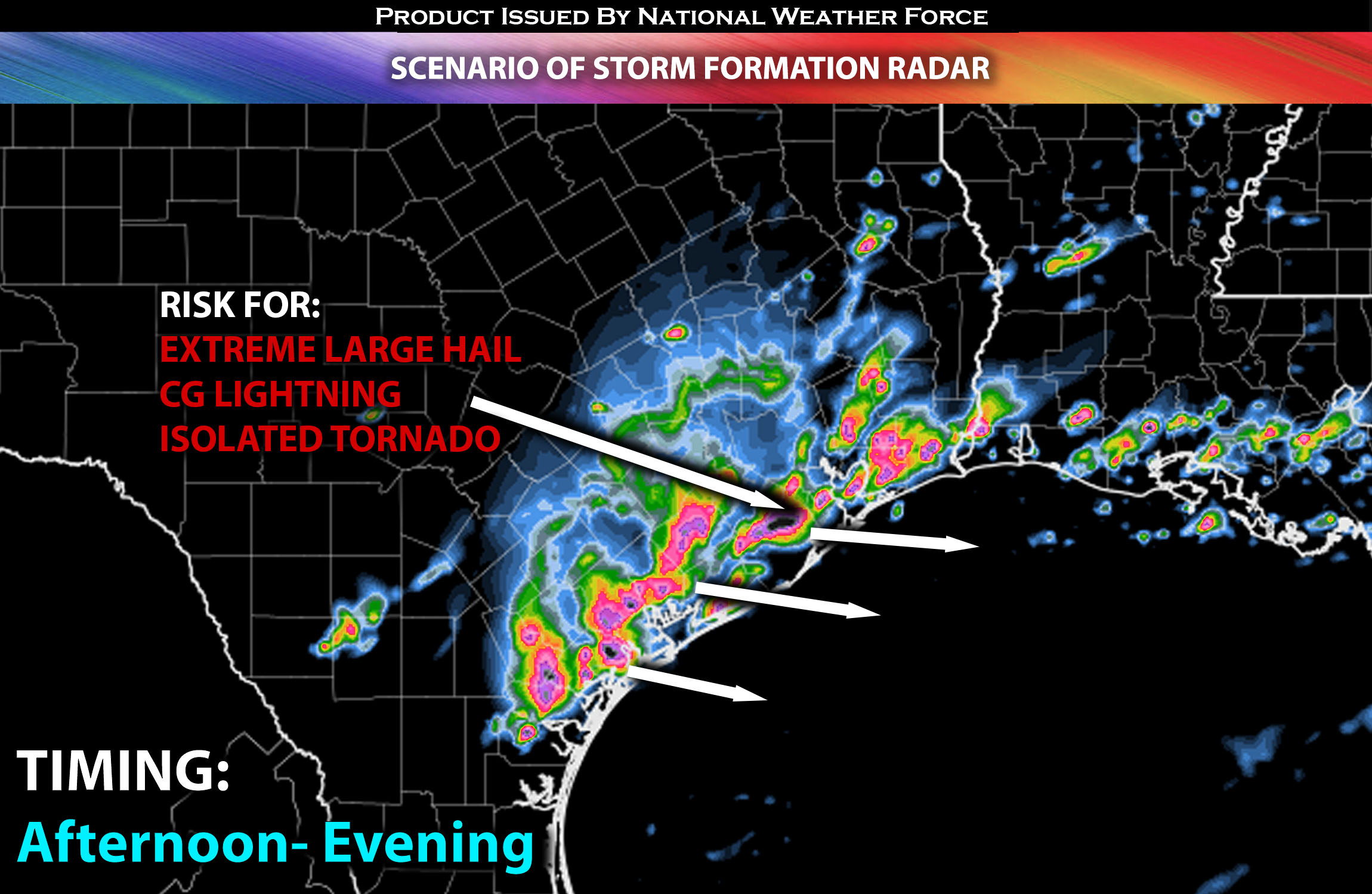
Main Risk: Extremely large hail, isolated tornado (if ingredients align), damaging winds and CG lightning (cloud to ground).
Stay tuned for more updates.
Sina⚡⚡
With over a decade of experience in forecasting severe thunderstorms, this individual is a seasoned forecaster and developer. Their expertise in severe weather forecasting and computer science is entirely self-taught, complemented by a foundation in Atmospheric Science from UNCO and an IT background from WGU. They have dedicated their efforts to developing innovative tools that enhance the accuracy of analyzing large hail and tornadoes. As a significant contributor and partner at National Weather Force Innovations LLC, they have played a crucial role in providing accurate and timely information. Additionally, they have been instrumental in developing tools and organizing projects that focus on accuracy and performance, ensuring those affected are well-informed.