
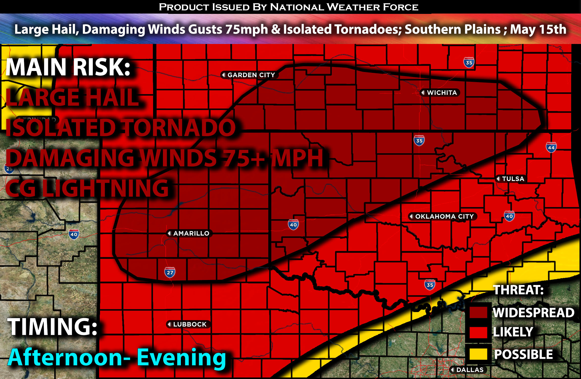
Outlook:
Clusters of severe thunderstorms are expected to form across the southern Plains this afternoon through the evening hours. These storms will be capable of producing large hail and very damaging winds, sometimes exceeding 75 mph. They will also pose a tornado threat if the ingredients align during the evening hours. For detailed information on timing, impacts, and more, refer below.
Overall Forecast:
A surface cyclone continues to develop and is expected to move across the High Plains. At the same time, moisture advection ahead of it is anticipated, being pulled up into the Plains. Combined with diurnal heating and other ingredients will allow for favorable circumstances for thunderstorm development.
Across the Southern Plains:
This afternoon, strong diurnal heating will lead to the formation of a deep, well-mixed, uncapped environment across the region. This will result in extreme mid-level lapse rates (change in temperature with height) with 2000-3000 J/kg instability over the area. Initially, storms are expected to form as high-based supercells and multicells. The primary threats at this stage will be very large hail and damaging winds. However, significant evaporative cooling within the deep, well-mixed boundary layer will foster the development of strong cold pools prone to merging.
Clusters of storms are then anticipated to move rapidly from the Texas/Oklahoma Panhandles into northwestern Oklahoma and southern Kansas by late afternoon/early evening hours. These storms will be preceded by increased low-level moisture and a strengthening low-level jet, enhancing the potential for severe wind gusts over 75 mph. Supercell structures may also initiate in the warm-air advection regime along the Kansas/Oklahoma border during the evening, allowing storms to be capable of large hail, damaging winds, and isolated tornadoes before being overtaken by merging cold pools from the west. As the night progresses, storms are expected to weaken as they get cut off.
Coverage Details:
Storms are expected to form from the Texas Panhandle into Oklahoma in the afternoon, moving east as clusters with a few remaining more discrete while most collide together, becoming multiple clustered storms. These storms will be capable of producing large hail and very damaging winds, sometimes exceeding 75 mph, through the late afternoon and evening hours before dissipating overnight as they move east.
Future Radar Scenario:
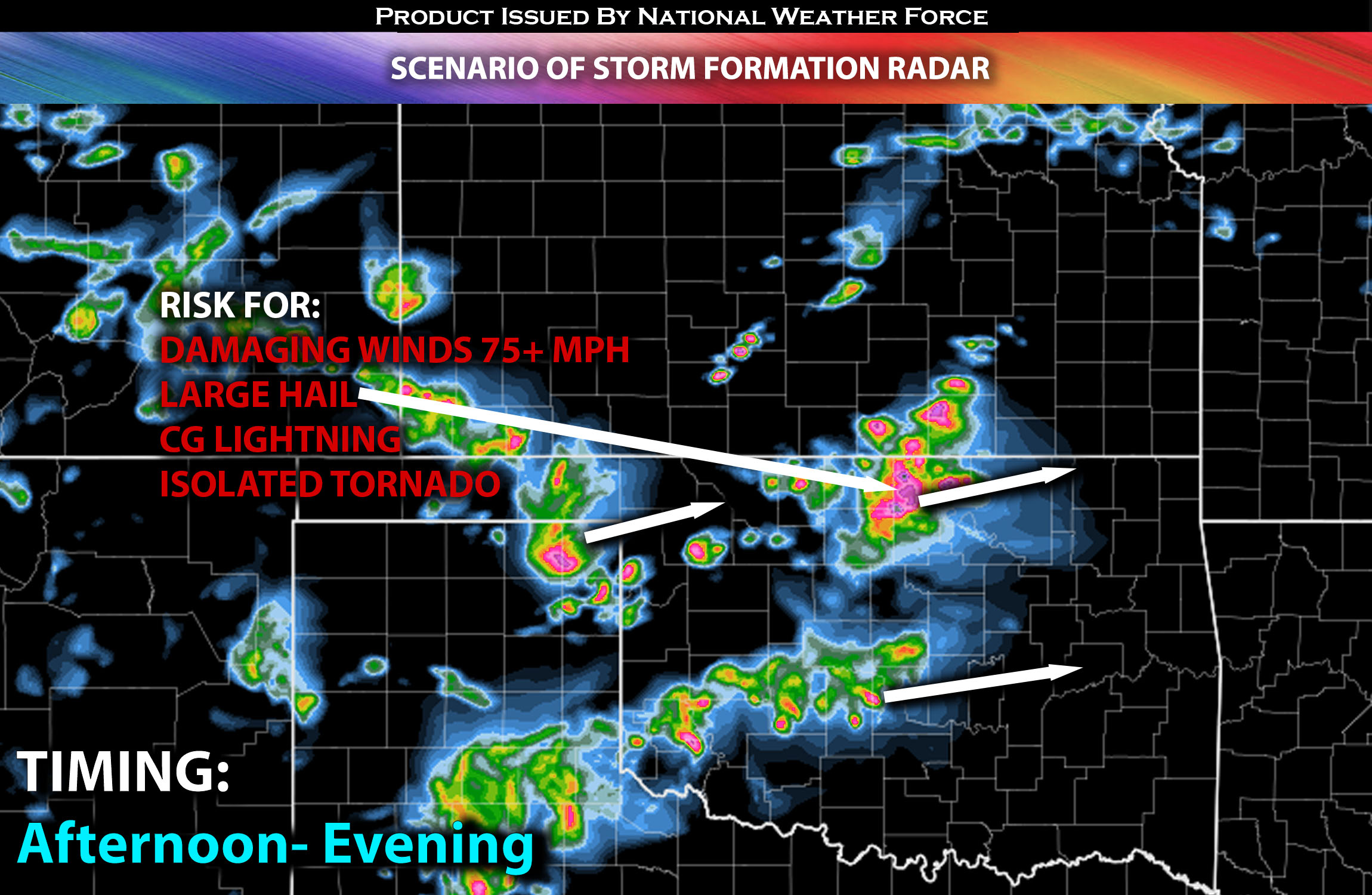
Main Risk: Large hail, damaging winds in excess of 75+ mph, isolated tornadoes (if ingredients align) and CG lightning (cloud to ground).
Stay tuned for more updates.
Sina⚡⚡
With over a decade of experience in forecasting severe thunderstorms, this individual is a seasoned forecaster and developer. Their expertise in severe weather forecasting and computer science is entirely self-taught, complemented by a foundation in Atmospheric Science from UNCO and an IT background from WGU. They have dedicated their efforts to developing innovative tools that enhance the accuracy of analyzing large hail and tornadoes. As a significant contributor and partner at National Weather Force Innovations LLC, they have played a crucial role in providing accurate and timely information. Additionally, they have been instrumental in developing tools and organizing projects that focus on accuracy and performance, ensuring those affected are well-informed.