
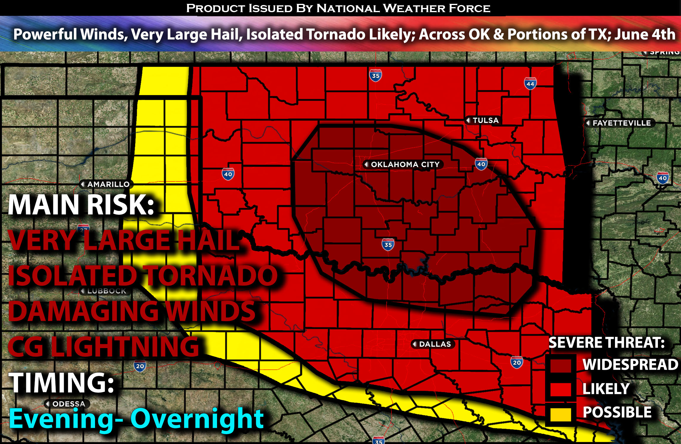
Outlook:
Severe storms are anticipated this evening and into the overnight hours. There is a potential for a tornado or two and large to very large hail early in the evening. As the night progresses and an MCS develops, severe outflow winds of 70-85 mph may accompany the more intense downdrafts. For detailed information on timing, impacts, and more, refer below. For detailed information on timing, impacts, and more, refer below.
Overall Forecast:
A complex weather setup is unfolding across Oklahoma, creating an unstable air mass conducive to severe storms with the potential for very damaging winds. This outflow air mass will sweep through Oklahoma, acting as a lifting mechanism. Surface dewpoints are expected to rise into the mid-70s across central and southern Oklahoma, where isolated thunderstorm development is anticipated by late this afternoon and early evening along the richer moisture.
Across Oklahoma Through Northern TX:
Extreme instability, with near 5000 J/kg of CAPE and minimal convective inhibition, will allow storms to rapidly intensify. However, ascent forcing will be challenging due to limited lifting mechanisms. Nonetheless, there may be a short window of opportunity for a tornado risk if a quasi-discrete mode occurs early in the convective life cycle. The very large buoyancy and nearly dry adiabatic lapse rates across Oklahoma will support large and tall storms capable of initially producing isolated very large hail. As storms grow upscale into another MCS tonight, the threat for damaging winds (70-85 mph) will increase. These storms will continue to sweep southeastward across portions of northern TX through the overnight hours.
Coverage Details:
Severe storms are expected to develop explosively this evening across western and central Oklahoma, capable of producing very large hail and perhaps an isolated tornado or two. These storms will continue moving southeast, eventually forming into an MCS with an embedded QLCS that will sweep through Oklahoma and reach northern Texas. Dallas and northern Texas are likely to be impacted by these storms due to the unstable air mass overnight. The primary risk at this point will be damaging winds.
Future Radar Scenario:
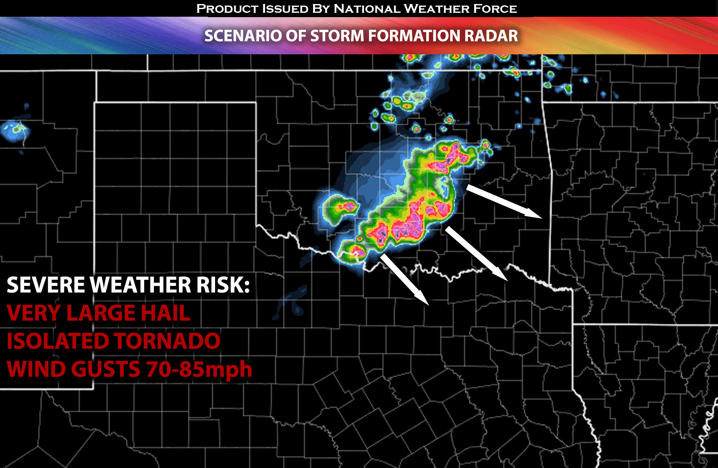
Main Risk: very large hail, powerful damaging winds, isolated tornadoes and CG lightning (cloud to ground).
Stay tuned for more updates.
Sina⚡⚡
With over a decade of experience in forecasting severe thunderstorms, this individual is a seasoned forecaster and developer. Their expertise in severe weather forecasting and computer science is entirely self-taught, complemented by a foundation in Atmospheric Science from UNCO and an IT background from WGU. They have dedicated their efforts to developing innovative tools that enhance the accuracy of analyzing large hail and tornadoes. As a significant contributor and partner at National Weather Force Innovations LLC, they have played a crucial role in providing accurate and timely information. Additionally, they have been instrumental in developing tools and organizing projects that focus on accuracy and performance, ensuring those affected are well-informed.