
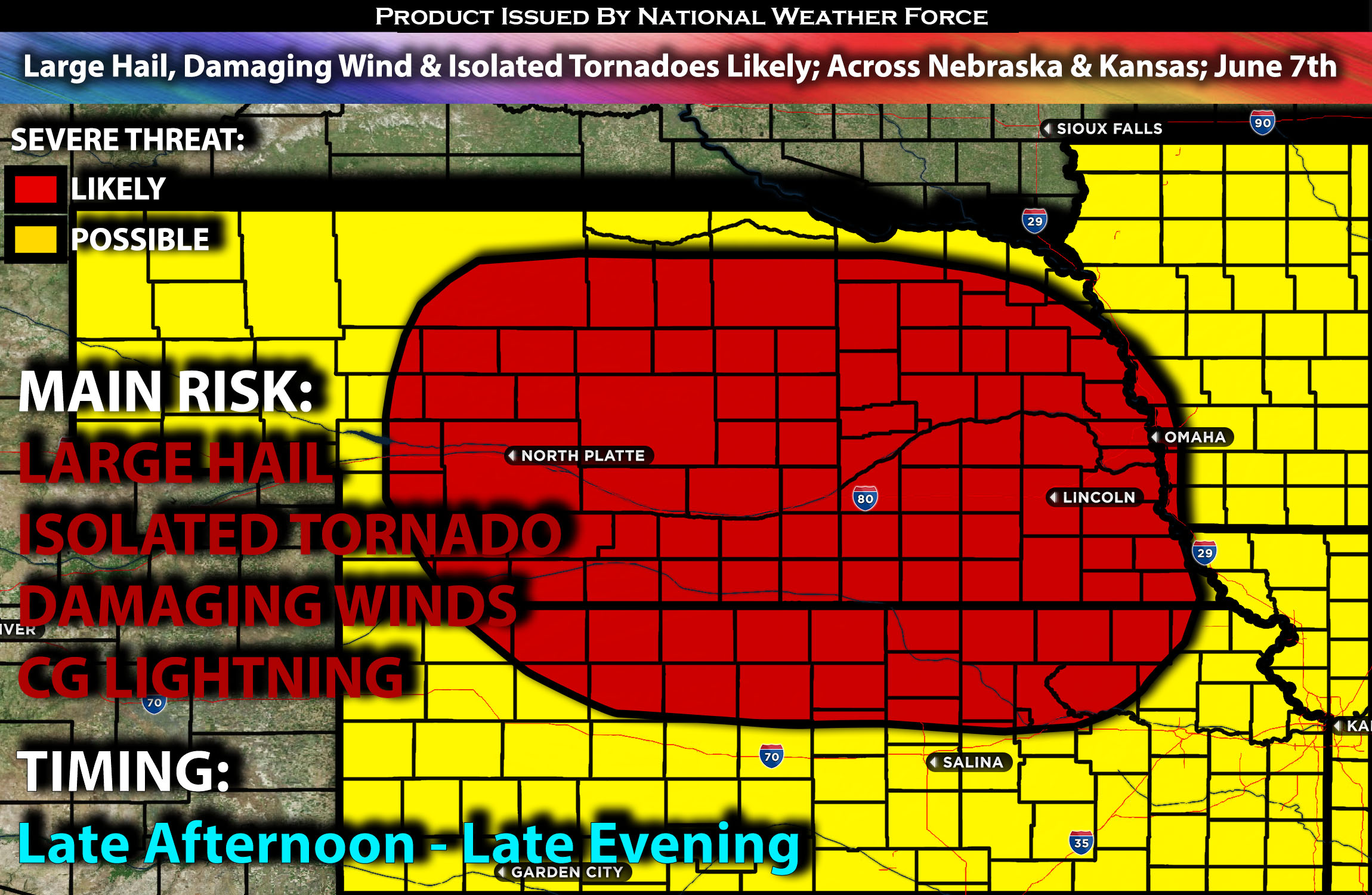
Outlook:
Severe storms are expected to form across portions of Nebraska and possibly in northern Kansas from late Friday afternoon through the evening hours. These storms may also continue as a cluster, eventually reaching western portions of Missouri. The storms will be capable of producing large hail and damaging winds. If a few storms can mature enough during the evening hours, an isolated tornado or two is also possible. For detailed information on timing, impacts, and more, refer below.
Overall Forecast:
A weak short-wave trough embedded within west-northwesterly flow aloft across the High Plains is expected to trigger weak cyclogenesis in the central Plains. Concurrently, warm air advection with efficient moisture is anticipated to push northward into Nebraska, with dew points expected to reach the 60s.
Across Portions of Nebraska and Kansas:
A warm front is also forecasted to be over the area. This combination of factors, along with heating and destabilization of the low-level air mass, will likely lead to storm formation in northern Nebraska.
A south-southwesterly jet is expected to develop by evening, bringing deep effective layer shear and some low-level shear, which could enable storms to rotate. Initially, these discrete storms will primarily pose a risk of large hail and damaging winds, but isolated tornadoes will also be possible, especially near the warm front due to potential rotating storms.
As the evening progresses, this convection may grow upscale, potentially merging with an eastward-moving cluster of ongoing storms. This merged system could then spread across the Mid-Missouri Valley overnight. However, storms are expected to dissipate and weaken quickly as they move further into the region due to the lack of sufficient ingredients.
Coverage Details:
As destabilization occurs, storms are expected to form in the late afternoon and increase in coverage, especially during the evening hours, across central and eastern Nebraska, moving south southeastward. These storms will be capable of producing all types of hazards, particularly during the evening hours, before clustering together and eventually reaching Missouri as a line. At this point, the main risk will be damaging winds. These storms will then quickly dissipate overnight in Missouri due to the lack of ingredients.
Future Radar Scenario:
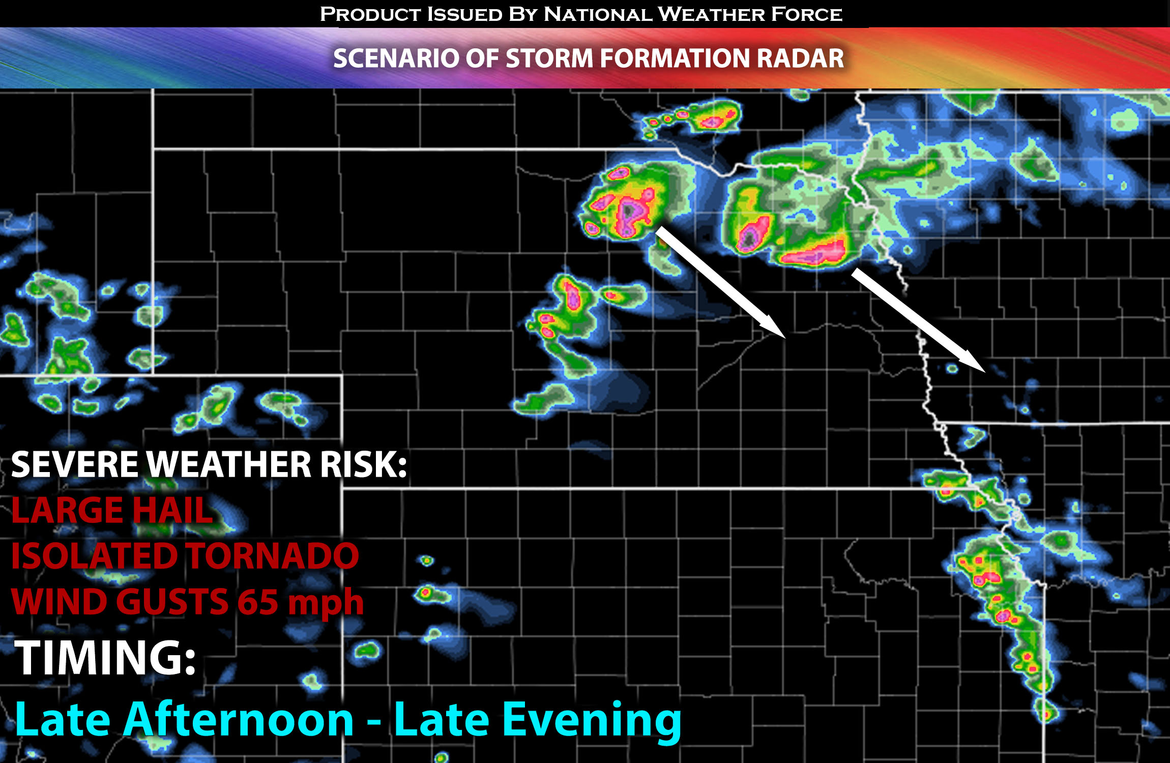
Main Risk: large hail, damaging winds, isolated tornadoes and CG (cloud to ground) lightning.
Stay tuned for more updates.
Sina⚡⚡
With over a decade of experience in forecasting severe thunderstorms, this individual is a seasoned forecaster and developer. Their expertise in severe weather forecasting and computer science is entirely self-taught, complemented by a foundation in Atmospheric Science from UNCO and an IT background from WGU. They have dedicated their efforts to developing innovative tools that enhance the accuracy of analyzing large hail and tornadoes. As a significant contributor and partner at National Weather Force Innovations LLC, they have played a crucial role in providing accurate and timely information. Additionally, they have been instrumental in developing tools and organizing projects that focus on accuracy and performance, ensuring those affected are well-informed.