
 Outlook:
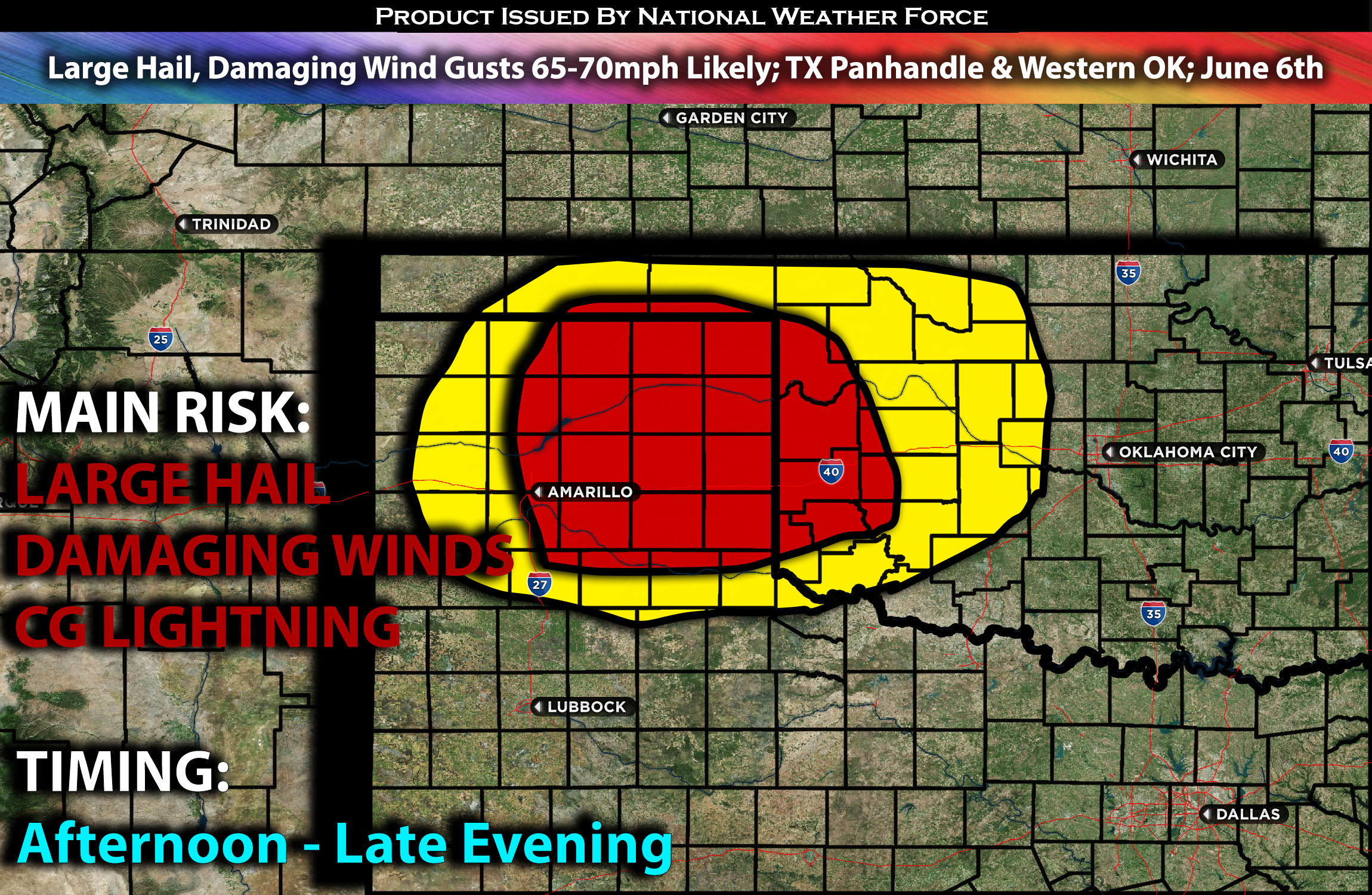
A few severe storms are anticipated to form across the Texas Panhandle into portions of western Oklahoma, mainly scattered in clusters. The main risks will be large hail and damaging winds, with a few wind gusts reaching the 65-70 mph range. These storms are expected from the afternoon through the evening hours before diminishing. For detailed information on timing, impacts, and more, refer below. For detailed information on timing, impacts, and more, refer below.
Overall Forecast:
With most of the flow being further north, the potential for severe weather will have a slightly decreasing impact over the area. However, a weak surface cold front will drift southward from Kansas into northern Oklahoma and the Texas/Oklahoma Panhandles by late afternoon through the evening hours. Northward moisture advection across Texas and Oklahoma, south of the front, will combine with strong surface heating and increasing low-level moisture to contribute to moderate buoyancy by mid to late afternoon. This will create efficient instability, especially downward, in an environment characterized by steep low-level lapse rates and deep mixing.
Across Texas Panhandle/Western OK:
Thunderstorms are expected to develop by mid to late afternoon from northwest Oklahoma into the Texas Panhandle, spreading southward through the evening and quickly becoming severe. The moderate buoyancy and effective bulk shear of around 30-35 knots will favor a mix of multicell clusters and high-based supercells. These storms will be capable of producing severe outflow gusts, mainly 65-70 mph, and isolated large hail in some cells.
Coverage Details:
Storms are expected to form ahead of the cold front in the northern portions of the Texas Panhandle and into the northwestern portion of Oklahoma as destabilization occurs. However, these storms are not expected to be very organized, with a few cells capable of producing spotty large hail and mainly damaging wind gusts from the late afternoon through late evening before diminishing quickly.
Future Radar Scenario:
Main Risk: large hail, damaging winds, very low risk for tornado and CG lightning (cloud to ground).
Stay tuned for more updates.
Sina⚡⚡
With over a decade of experience in forecasting severe thunderstorms, this individual is a seasoned forecaster and developer. Their expertise in severe weather forecasting and computer science is entirely self-taught, complemented by a foundation in Atmospheric Science from UNCO and an IT background from WGU. They have dedicated their efforts to developing innovative tools that enhance the accuracy of analyzing large hail and tornadoes. As a significant contributor and partner at National Weather Force Innovations LLC, they have played a crucial role in providing accurate and timely information. Additionally, they have been instrumental in developing tools and organizing projects that focus on accuracy and performance, ensuring those affected are well-informed.