
 Outlook:
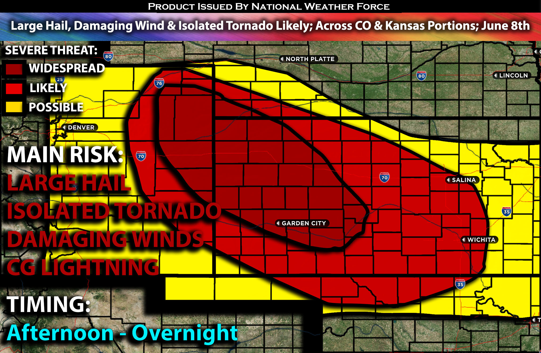
Severe storms are likely across the Central High Plains on Saturday afternoon, particularly from eastern Colorado into portions of Kansas. An MCS is expected to form across Kansas, with the threat shifting to damaging winds into the evening hours and overnight before diminishing in the south-central Kansas area. The main threats will be damaging winds and large hail, given the ingredients present. An isolated tornado is also possible but not the primary risk. For detailed information on timing, impacts, and more, refer below.
Overall Forecast:
Diurnal heating and upslope flow are anticipated over the Central High Plains, leading to isolated storms forming, especially across the eastern/northeastern Colorado area, moving southeastward. These storms could quickly become severe. They should develop over the Front Range during the afternoon.
Across the Central High Plains:
With a deep and dry boundary layer expected, initially sparse convection should gradually grow upscale through the afternoon. As a cold pool evolves and acts as a boundary causing lift, and with west-northwesterly mid-level flow atop a developing southerly low-level jet, upscale growth into an east-southeastward-moving Mesoscale Convective System (MCS) is anticipated. The main risks associated with this MCS will be locally damaging winds and hail. Storms are expected to diminish overnight as the low-level jet veers away.
Coverage Details:
As destabilization occurs in the afternoon, storms are anticipated to form across eastern Colorado, particularly in the northeastern portions. These storms will mostly be isolated and capable of producing large hail and downdraft winds. An MCS is expected to form in eastern Colorado and move into Kansas, with the primary threat shifting to damaging winds in the evening hours. This MCS, along with a line of storms, is expected to continue moving southeast to east across Kansas into central Kansas, eventually diminishing in the south-central Kansas area and possibly eastern Kansas overnight.
Future Radar Scenario:
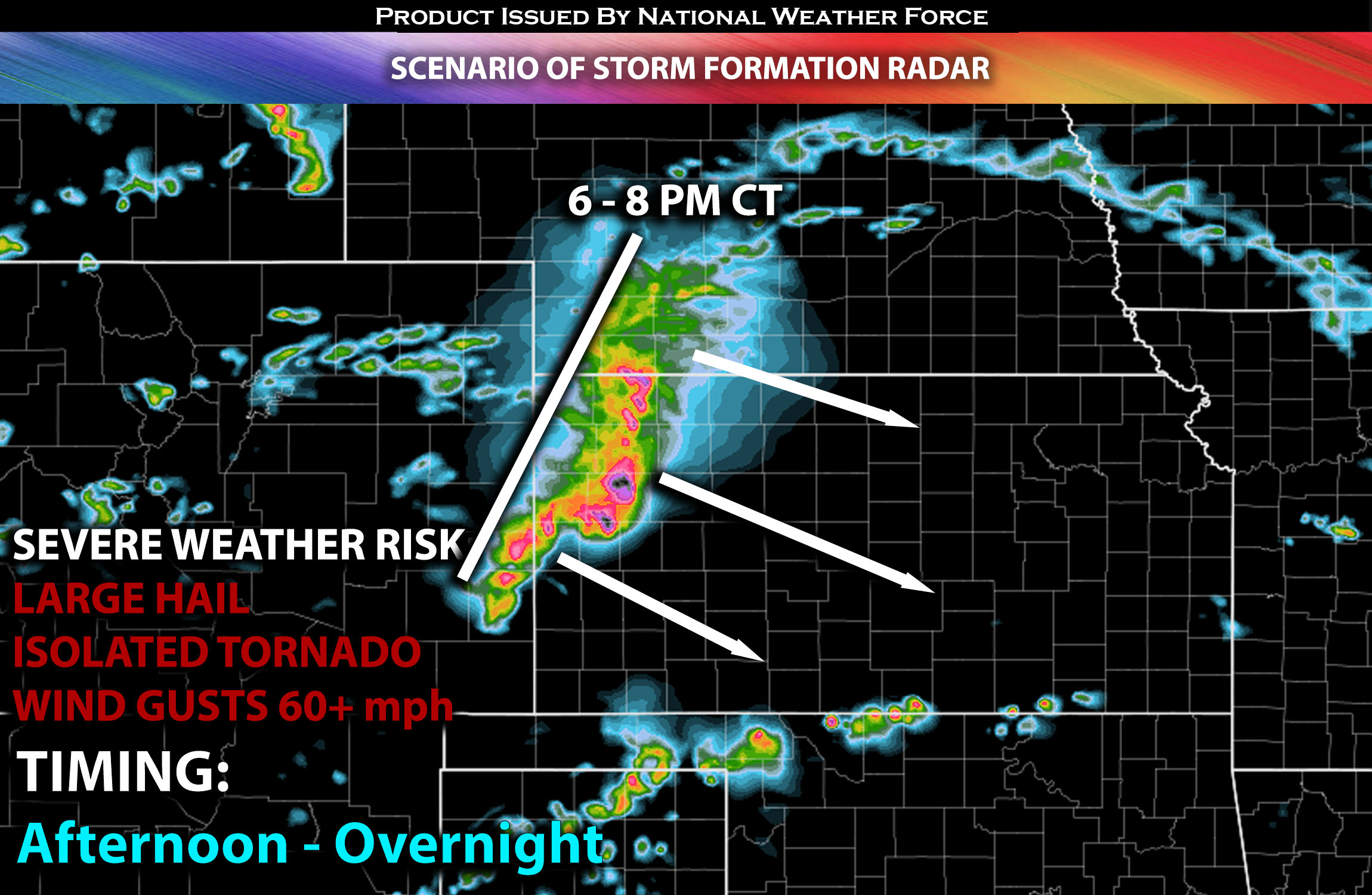 Main Risk: large hail, damaging winds, isolated tornado and CG (cloud to ground) lightning.
Stay tuned for more updates.
Sina⚡⚡
With over a decade of experience in forecasting severe thunderstorms, this individual is a seasoned forecaster and developer. Their expertise in severe weather forecasting and computer science is entirely self-taught, complemented by a foundation in Atmospheric Science from UNCO and an IT background from WGU. They have dedicated their efforts to developing innovative tools that enhance the accuracy of analyzing large hail and tornadoes. As a significant contributor and partner at National Weather Force Innovations LLC, they have played a crucial role in providing accurate and timely information. Additionally, they have been instrumental in developing tools and organizing projects that focus on accuracy and performance, ensuring those affected are well-informed.