
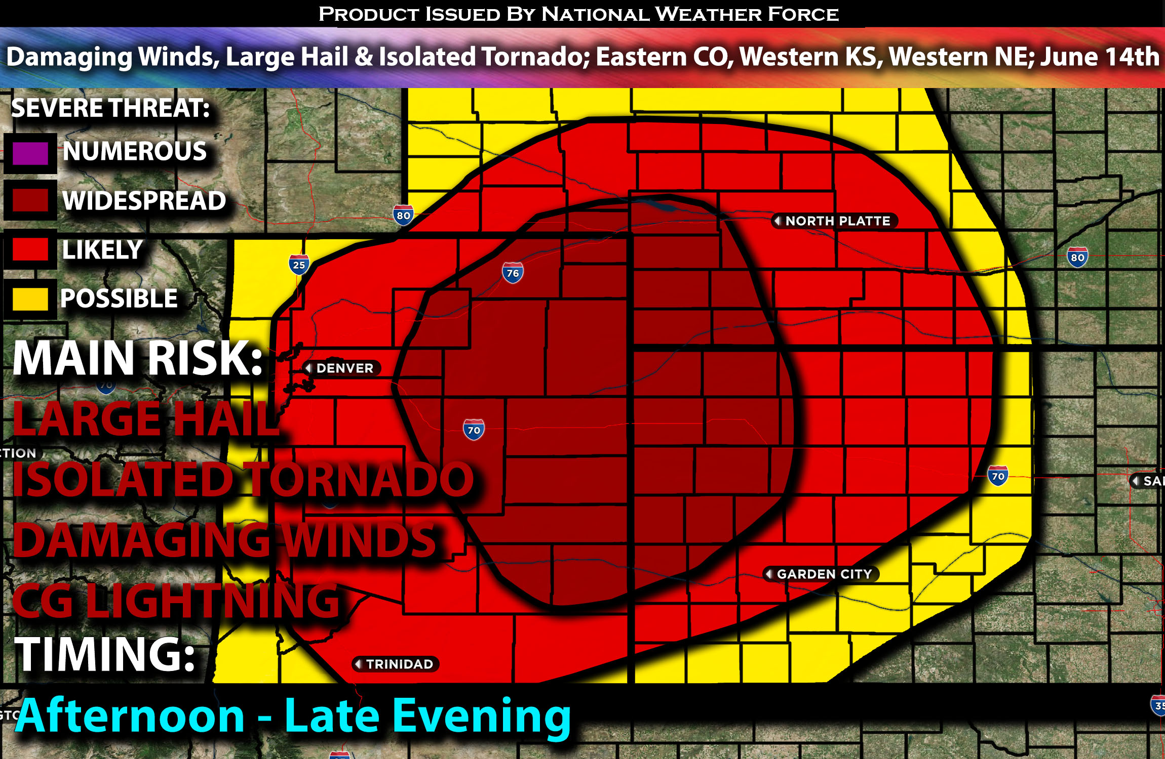
Outlook:
Severe storms are expected across portions of central and especially eastern Colorado, extending into western Kansas and Nebraska, from the afternoon through the evening hours. The main risks associated with these storms will be large hail, damaging wind gusts, and perhaps an isolated tornado. For detailed information on timing, impacts, and more, refer below.
Overall Forecast:
A shortwave trough is expected to approach the Four Corners area by Friday afternoon and continue toward the central High Plains through early Saturday, moving northeast. This movement will coincide with mid to upper-level flow enhancement along the southern edge of the trough, accompanied by substantial warming in its southwest quadrant. Consequently, the overall wind profiles will be modest compared to the typical conditions in the central High Plains. Nonetheless, the broad uplift associated with the approaching trough will facilitate the development of scattered to widespread thunderstorms, initiating from higher terrain and moving onto the adjacent plains later in the afternoon.
Across Central/Eastern CO, Western KS & Western NE:
At the surface, a stationary front, influenced by prior convection, is expected to extend from the Ozark Plateau west-northwest into the central High Plains. During the peak of the day’s heat, a deeply mixed and hot air mass to the south will become unstable. Along and just north of this front, enhanced low-level moisture, combined with steep mid-level lapse rates, will support storm formation.
Efficient deep-layer shear profiles are expected to facilitate a cluster of storms moving into the High Plains. Upon interacting with the concentrated buoyancy along the frontal zone, bowing structures may emerge, forming a moderately organized Quasi-Linear Convective System (QLCS), also known as a squall line, that moves east-northeast into western Kansas and Nebraska. The main risks will be damaging winds and large hail, especially before the storms cluster up in the afternoon. These storms are then expected to diminish overnight.
Coverage Details:
As destabilization occurs around 1-2 PM MT, storms are expected to form across the higher terrain, with additional storms developing across central and especially eastern Colorado. The main risk for severe storms will be more pronounced to the east in Colorado, where these storms are expected to collide and form a cluster. This cluster may evolve into a squall line (QLCS) as it moves into portions of western Kansas and southwestern Nebraska, then gradually diminish overnight.
Main Risk: large hail, damaging winds, isolated tornado and CG (cloud to ground) lightning.
Stay tuned for more updates.
Sina⚡⚡
With over a decade of experience in forecasting severe thunderstorms, this individual is a seasoned forecaster and developer. Their expertise in severe weather forecasting and computer science is entirely self-taught, complemented by a foundation in Atmospheric Science from UNCO and an IT background from WGU. They have dedicated their efforts to developing innovative tools that enhance the accuracy of analyzing large hail and tornadoes. As a significant contributor and partner at National Weather Force Innovations LLC, they have played a crucial role in providing accurate and timely information. Additionally, they have been instrumental in developing tools and organizing projects that focus on accuracy and performance, ensuring those affected are well-informed.