
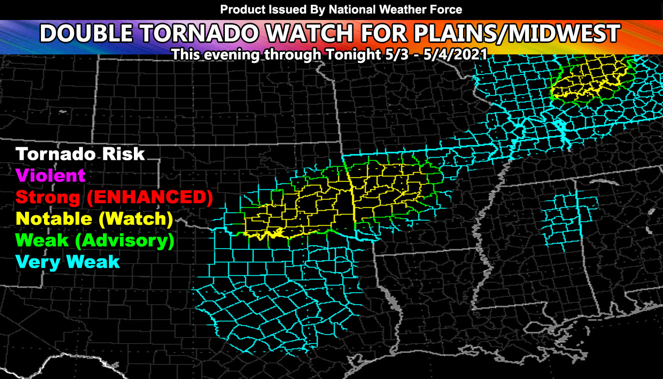
National Weather Force has issued a double tornado watch for Oklahoma, Arkansas, and parts of Southern Indiana and Northern Kentucky, with tornado dynamics extending into the Dallas-Fort Worth areas as well so read on for details …
Discussion: The National Weather Force tornado model has finished running and between this evening and tonight there will be a number of strong tornadoes within the watch areas. This all comes on the 22nd anniversary of the May 3, 1999 tornado outbreak. What is different from that however and this is that these will happen mostly when it is dark, happening between the evening and the way overnight hours into early Tuesday morning.
The first watch will go from Southern Oklahoma, through eastern state, and into Arkansas. This watch consists of the stronger tornado dynamics. In the upper levels, a strong trough moving in out of the Southwestern United States this evening will bring a very strong area of upper divergence. Where the cells form, this ‘exhaust’ will make for a strong tornado scenario, probably up to EF3 potential if a cell can form directly under the upper divergence zones and along the boundary. Areas within this is McAlester, Oklahoma and Fort Smith, Arkansas. The line of supercells will extend south into Texas, including the Dallas-Fort Worth areas. Weaker dynamics exist down there on the model, however it still does include a tornado risk for you.
The second watch is a small one across Southern Indiana and Northern Kentucky. It is showing notable tornado dynamics there, which is enough for up to EF2 and maybe EF3 if conditions set. This is an overnight event especially in that area. An area of severe storms moving through Northern Missouri right now will be the root of the watch reasoning later on as they latch onto the surface boundary.
In addition to the tornado threat, ALL AREAS will have a risk of large hail and damaging winds.
If you are in the blue, green, or yellow shade for this event from this evening through the overnight, you received this via the free e-mail alert system.
Want notifications? Sign into the free email alert system and choose your state area(s) -Southern California and Arizona are not served though.
LINK TO REGISTER IF ELSEWHERE – http://www.nationalweatherforce.com/national-weather-force-email-alert-system-sign-up/
Have a comment? Ask on the FB post – You can even ask your city and get an answer if you are confused – The NWF Facebook Page Link By Clicking Here
Double Tornado Watch Issued On Anniversary of May 3, 1999 Tornado Outbreak In Tornado Alley; Strong Tornadoes Target…
Posted by National Weather Force on Monday, May 3, 2021