
 Outlook:
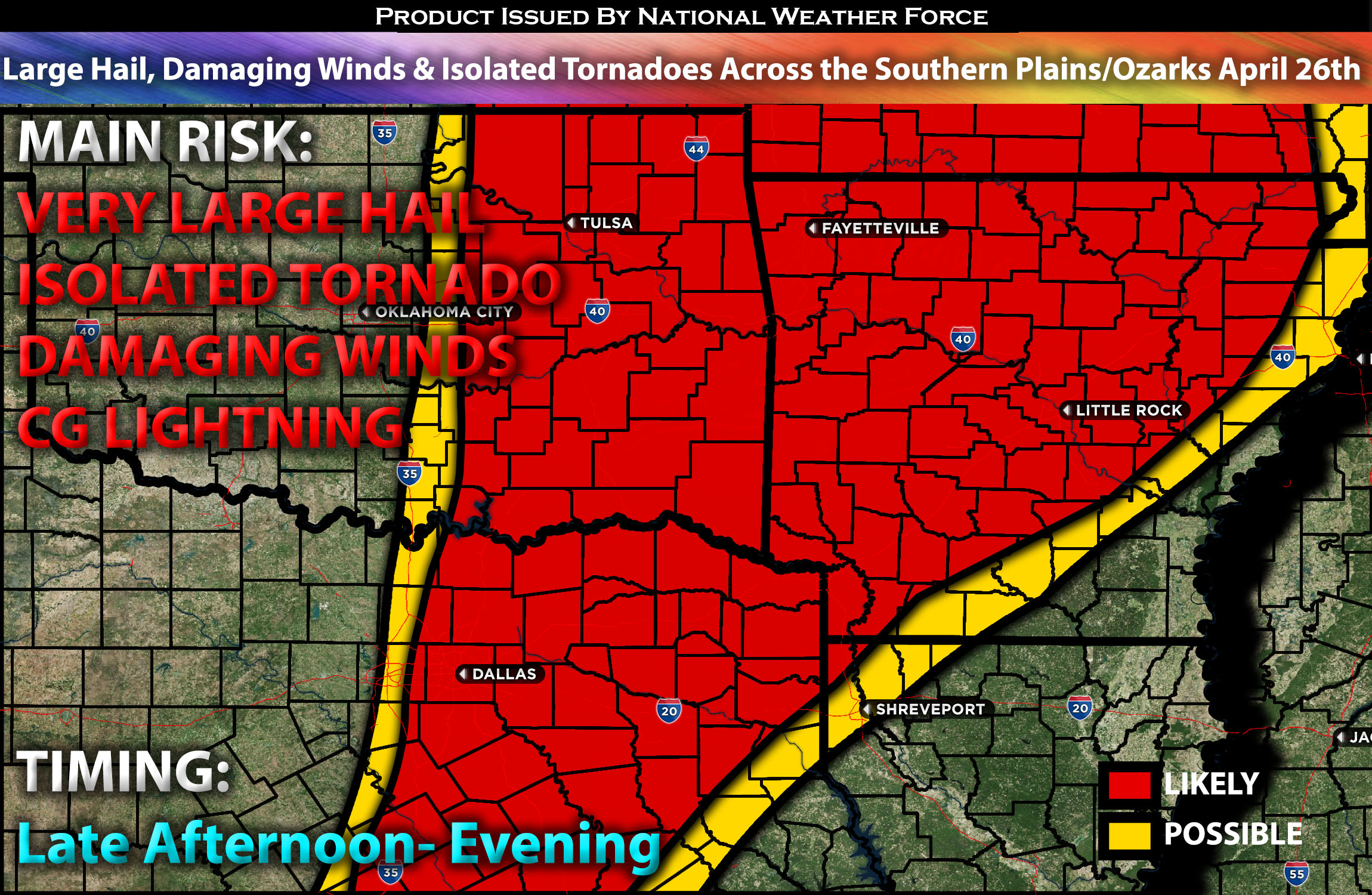
Severe storms with multiple rounds are expected from Friday morning through Friday evening across the southern Plains into the Ozarks. The main risks associated with these storms will be large hail, damaging winds, and isolated tornadoes. Please see below for further details, including timing, impact, and the risk area.
Overall Forecast for the Southern Plains Extending into the Ozarks:
A negatively tilted trough is forecast to continue its northeastward trajectory, eventually positioning itself over the northern Plains. Accompanying this movement will be a 60-70 knot mid-level jet, which will help maintain strong deep-layer shear. Simultaneously, a broad southerly low-level jet will extend from the southern Plains and Ozarks northward to Iowa. This setup will facilitate the northward flow of low-level moisture into the Ozarks, Ark-La-Tex, and the central Plains.
Ongoing storms will move across the southern plains, with additional storms anticipated in Oklahoma and Arkansas overnight before gradually diminishing. As daylight increases and instability redevelops, coupled with deep moisture and effective shear, another round of severe storms is expected to form across these regions in the afternoon and evening. This will occur despite weak large-scale ascent, with more significant lifting expected further north in higher-risk areas. Across much of the southern Plains and the Ozarks/Ark-La-Tex region, the atmospheric cap is expected to weaken, likely leading to the development of isolated thunderstorms by late afternoon, persisting into the evening. These storms will be capable of producing very large hail, damaging winds, and isolated tornadoes.
Main Risk: very large hail, damaging winds, isolated tornado possible and CG lightning (cloud to ground).
Approximate Timing: Storms will be ongoing into the early morning hours across the southern Plains and the Ozarks. These storms are expected to dissipate, with another round firing up in the late afternoon and continuing into the mid-evening hours across the OK/AR area. These storms will be isolated before diminishing as night falls.
Stay tuned for more updates.
Sina⚡⚡
With over a decade of experience in forecasting severe thunderstorms, this individual is a seasoned forecaster and developer. Their expertise in severe weather forecasting and computer science is entirely self-taught, complemented by a foundation in Atmospheric Science from UNCO and an IT background from WGU. They have dedicated their efforts to developing innovative tools that enhance the accuracy of analyzing large hail and tornadoes. As a significant contributor and partner at National Weather Force Innovations LLC, they have played a crucial role in providing accurate and timely information. Additionally, they have been instrumental in developing tools and organizing projects that focus on accuracy and performance, ensuring those affected are well-informed.