
 Outlook:
Anticipate significant severe weather, with the possibility of very large hail, gusts reaching around 80 mph, and potentially strong QLCS tornadoes. For detailed information on timing, impacts, and more, refer below.
Overall Forecast:
An upper-level system, initially open, is predicted to advance eastward across the central Rockies and into the central Plains on Monday, gradually adopting a more negatively tilted orientation over time. Accompanying this system will be strong to very strong mid-level flow, extending eastward and northeastward into the southern High Plains by Monday afternoon and evening.
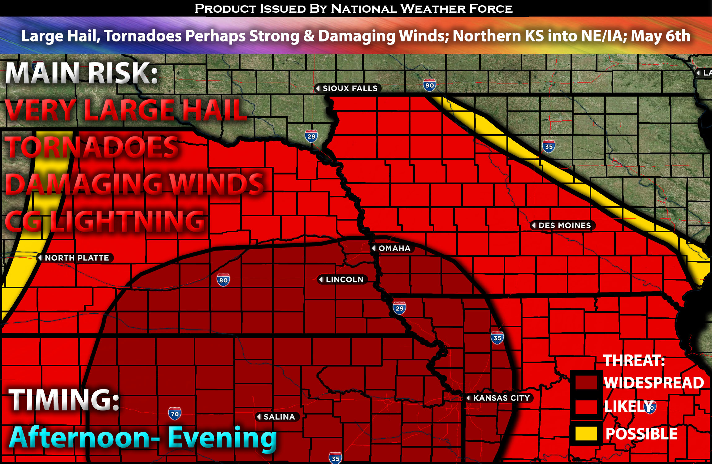
Across Northern KS into Portions of NE/IA into MO:
Anticipated storm initiation in western Kansas and southwest Nebraska is expected to occur earlier than in other regions, attributed to the timing of the upper-level forcing and system dynamics. This early initiation is likely to foster the rapid establishment of a linear storm mode, driven by the deep layer shear aligning more parallel to the initiating boundary compared to areas farther south. As storms progress northward, buoyancy levels are anticipated to diminish gradually. However, moisture influx will persistently advance northward throughout the day and into the evening, potentially resulting in mid-60s F dewpoints reaching southeast Nebraska, into IA and MO.
The combination of strong deep-layer and low-level shear will facilitate the organization of a convective line, capable of generating wind damage and QLCS (Quasi-Linear Convective System) tornadoes, with some potentially being strong. Additionally, there exists a possibility for discrete storm development ahead of the anticipated line, posing an elevated risk for significant tornadoes. Large to very large hail is expected to be more prevalent in western and central Kansas, with the extent of very large hail contingent upon the duration of maintenance of a discrete storm mode. These storms are capable of very large hail, damaging winds and tornadoes perhaps strong (highest risk further towards southern KS and into OK).
Future Radar Scenario:
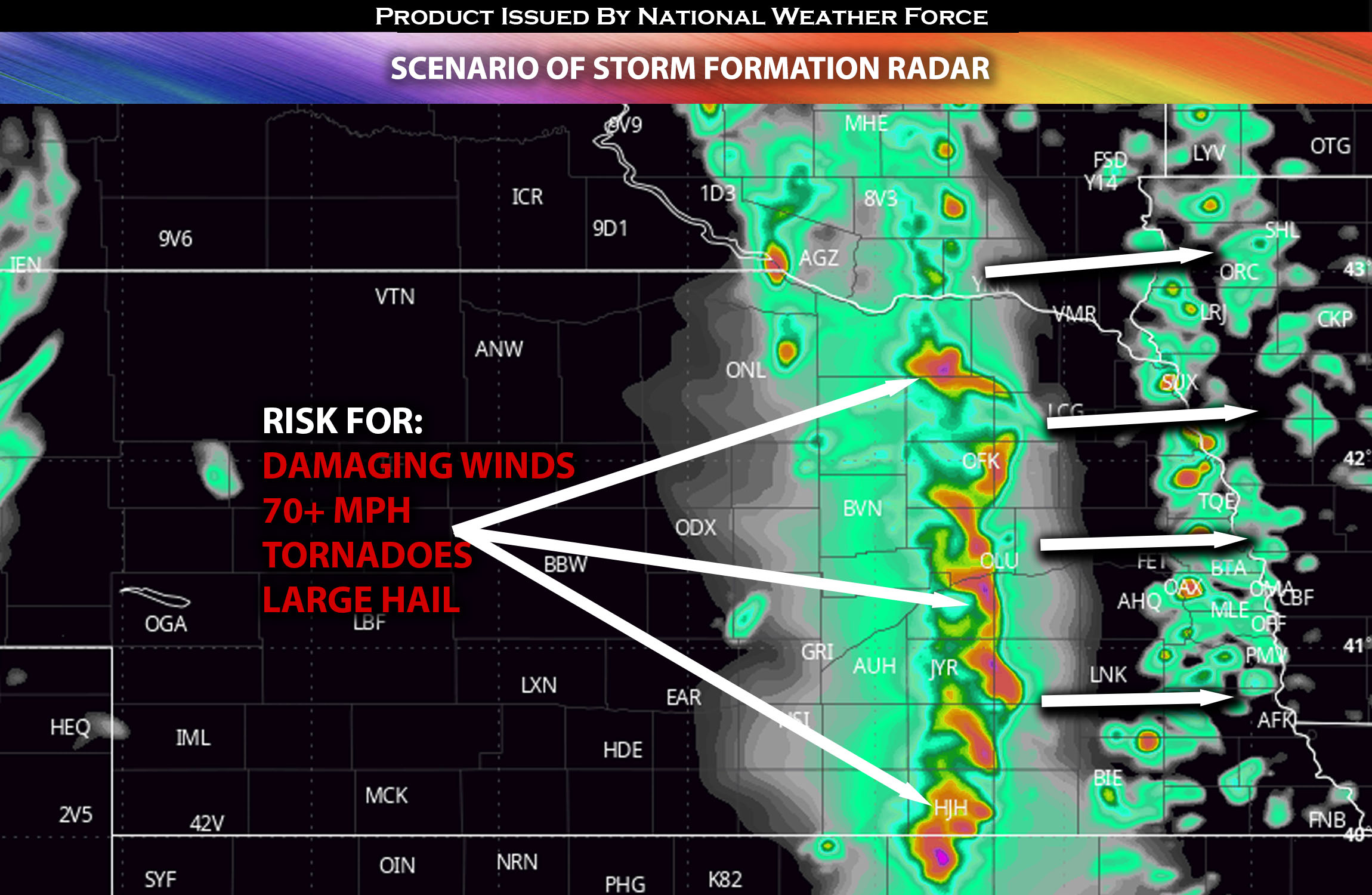 Main Risk: very large hail, tornadoes a few strong (if ingredients align), damaging winds and CG lightning (cloud to ground).
Stay tuned for more updates.
Sina⚡⚡
With over a decade of experience in forecasting severe thunderstorms, this individual is a seasoned forecaster and developer. Their expertise in severe weather forecasting and computer science is entirely self-taught, complemented by a foundation in Atmospheric Science from UNCO and an IT background from WGU. They have dedicated their efforts to developing innovative tools that enhance the accuracy of analyzing large hail and tornadoes. As a significant contributor and partner at National Weather Force Innovations LLC, they have played a crucial role in providing accurate and timely information. Additionally, they have been instrumental in developing tools and organizing projects that focus on accuracy and performance, ensuring those affected are well-informed.