
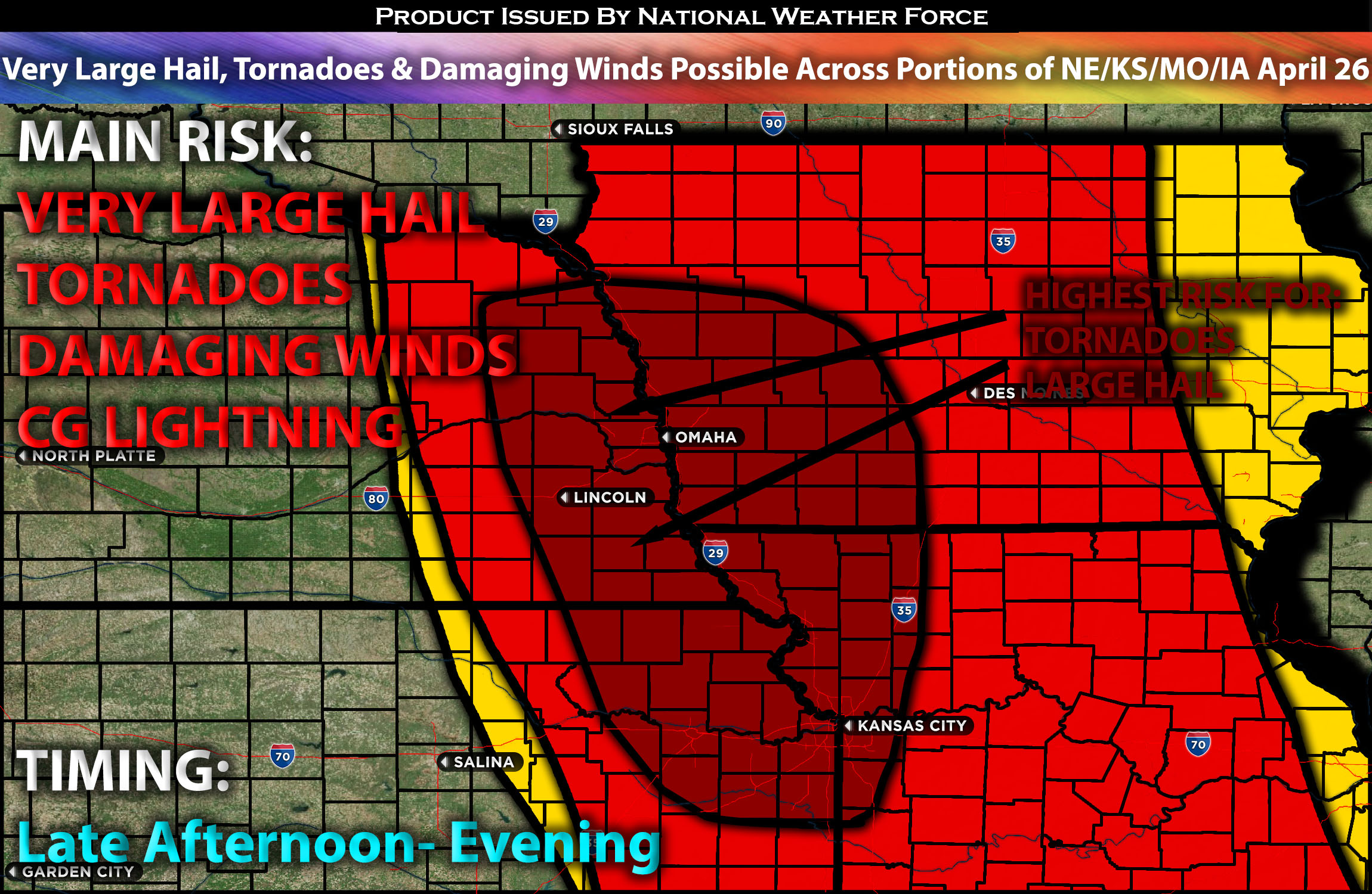
Outlook:
Severe storms are expected on Friday from parts of eastern Nebraska and northeast Kansas into northwest Missouri and Iowa. Tornadoes (possibly strong), very large hail, and damaging winds will all be threats to monitor with any cells. Please see below for further details, including timing, impact, and the risk area.
Overall Forecast for Portions Eastern NE/Northeast KS/Northwest MO and into IA:
The same trough that recently affected the central plains is expected to move northeast, positioning itself over the Northern Plains and becoming more negatively tilted over time. Accompanied by a 60-70 knot mid-level jet, this upper trough will help sustain strong deep-layer shear. Concurrently, a broad southerly low-level jet will extend from the southern Plains/Ozarks northward to Iowa. In response, low-level moisture will flow northward from the central Plains into parts of the Upper Midwest, aligning ahead of a deep surface low that is expected to develop northeastward across Nebraska and South Dakota by Friday evening. This scenario is characteristic of a classic cold core setup.
This, combined with strong low-level shear, deep-layer shear, and very strong instability, will allow for the formation of supercells capable of producing tornadoes (perhaps a strong one), very large hail, and damaging winds.
Main Risk: large hail, damaging winds, isolated possible and CG lightning (cloud to ground).
Approximate Timing: Depending on when destabilization occurs, likely in the late afternoon or evening, storms are expected to form somewhere in southeastern Nebraska, extending down to northeastern Kansas, ahead of the low pressure that is spinning northeastward. As they move eastward, they are anticipated to weaken quickly away from the source of ingredients, moving from eastern Iowa eastward overnight.
Stay tuned for more updates.
Sina⚡⚡
With over a decade of experience in forecasting severe thunderstorms, this individual is a seasoned forecaster and developer. Their expertise in severe weather forecasting and computer science is entirely self-taught, complemented by a foundation in Atmospheric Science from UNCO and an IT background from WGU. They have dedicated their efforts to developing innovative tools that enhance the accuracy of analyzing large hail and tornadoes. As a significant contributor and partner at National Weather Force Innovations LLC, they have played a crucial role in providing accurate and timely information. Additionally, they have been instrumental in developing tools and organizing projects that focus on accuracy and performance, ensuring those affected are well-informed.