
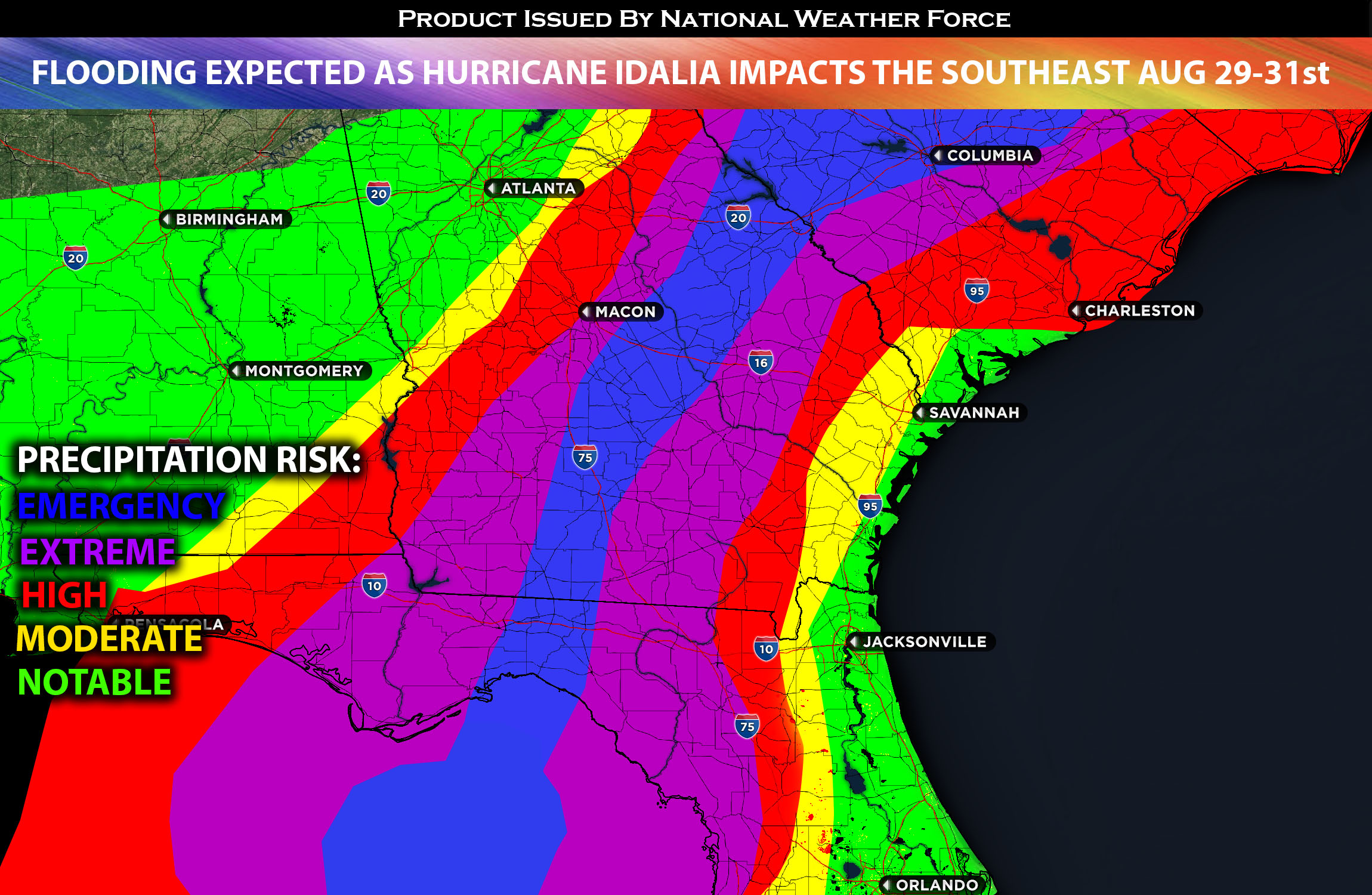
Hurricane Idalia is expected to impact Florida and the Southeast, bringing torrential heavy rain, damaging winds, and life-threatening storm surge. As it continues its track northward towards the Florida peninsula, Idalia is expected to hit the arc area between the Florida panhandle and Florida’s west coast, with the eye of the storm anticipated to make landfall somewhere between a Category 2 and Category 3 major hurricane, with winds around 120-130 mph near the eye wall. However, the focus should not just be on the eye wall, as widespread hurricane-force winds, life-threatening storm surge, and extreme flooding are expected throughout the Southeast. Some areas, especially western Florida, can anticipate storm surges of between 6-11 feet. Flooding is anticipated across much of the Southeast, not just in Florida. Areas of particularly concerning flooding will be in western and panhandle Florida, southeastern Georgia, coastal South Carolina, and southern North Carolina before the hurricane exits the region. Another factor in this event will be the supermoon, which will bring large waves on top of the storm surge expected from Idalia, creating a catastrophic combination with the highest impact in some areas. As Idalia exits on Thursday night, the remaining moisture could potentially bring more activity across the Southeast, on top of the already significant precipitation.
Main risk: Widespread damaging winds, extreme heavy rainfall leading to flooding, life threatening storm surge, and isolated tornadoes especially near the core and east side of Idalia.
Timing: Major impacts expected to FL westward around tonight (August 29th) and continue into GA, SC, NC through Wednesday and out of the area by Thursday night.
Locations Impacted: FL Panhandle, FL West, FL northwest, north, northeast; GA south, southeast; SC east; NC east especially the coasts.
Stay tuned for more updates.
Sina⚡⚡
With over a decade of experience in forecasting severe thunderstorms, this individual is a seasoned forecaster and developer. Their expertise in severe weather forecasting and computer science is entirely self-taught, complemented by a foundation in Atmospheric Science from UNCO. They have dedicated their efforts to developing innovative tools that enhance the accuracy of analyzing large hail and tornadoes. As a significant contributor to the National Weather Force, they have played a crucial role in providing accurate and timely information, as well as developing tools to keep those affected well-informed.
NOTE: The alerts and outlooks posted here are customary made to inform. At times, which is often, you will see an alert forecast posted on here that you do not see elsewhere. That is fine, the track record of the main office is very high so maintain to follow an event when posted. These are custom concentrated alerts and outlooks that are created by National Weather Force team of experts.
—————————