
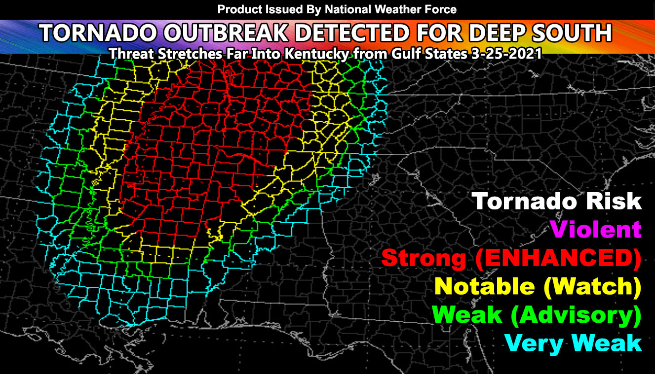
A Tornado Outbreak is scheduled for Dixie Alley stretching from Arkansas to the west, and Alabama to the East, with focus states of AL/MS/TN/and Kentucky for Thursday March 25, 2021 and the National Weather Force tornado risk model is running for the event so read on for details …
The day will start with two areas of weak tornado dynamics developing across the Southern half of Mississippi out ahead of another area along the main cold-front back across Central Arkansas. The National Weather Force tornado risk model does show very weak potential in both areas for the start.
As we move along the afternoon we see the area increasing in coverage as the storm system further ejects out of the west into Dixie Alley. Plenty of backing of surface winds available across the MS/AL/TN and even KY zones with multiple impulses of upper divergence moving across the area will make for a complex and dangerous event. I still do not see a high risk need, however the red-shade is intensity 4 out of 5 for me, which is considered a moderate risk . Still, the instability corridor will stretch well into Kentucky from MS/AL/TN and activity moving out of Northeast Arkansas will need to be monitored.
There is a good chance that most of the tornado dynamics will be across Tennessee with this event, however the entire red-shaded region should be considered a dangerous zone with multiple tornado touchdowns. This will be an outbreak of them. Unlike last week, I do not see much for the Southern half of Alabama and the activity will weaken as it moves into Eastern KY/TN and Northern Georgia. With over 20 factors in the National Weather Force tornado risk model, any changes in the final forecast could reflect a shift in the red-shaded area. But, because it looks the same as yesterday’s main threat shade (click here to read that) it shouldn’t shift much or at all. Areas within the strongest zone remains the North/Northeast half of MS, Northwest half of AL, most of TN/KY, and back into the Eastern half of Arkansas where the activity will start along that front early in the period. I also did include parts of Southeastern Missouri, the Bootheel Region.
Want notifications? Sign into the free email alert system and choose your state area(s) -Southern California and Arizona are not served though.
LINK TO REGISTER IF ELSEWHERE – http://www.nationalweatherforce.com/national-weather-force-email-alert-system-sign-up/
Have a comment? Ask on the FB post – You can even ask your city and get an answer if you are confused
Tornado Outbreak Predicted For Deep South to Kentucky For Thursday March 25, 2021; Enhanced Tornado Watch Likely
A…
Posted by National Weather Force on Wednesday, March 24, 2021