
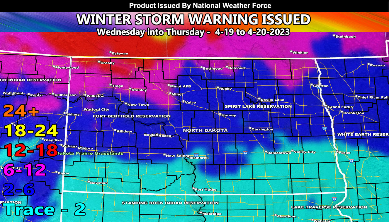
National Weather Force has issued a Winter Storm Warning for the Northern half of North Dakota effective Wednesday into Thursday, April 19th and 20th, 2023. A snowfall map from the NWF snow forecast model has been developed, which is the main image in this article. The lower-left numbers is the snowfall forecast in inches and the shaded color within the map is the value to the key projected.
A storm system that will bring severe thunderstorms to Wyoming today will move northeast out of that state and into the Dakotas by Wednesday morning. This crossing will develop a surface low that will bring colder air into it from Canada. Heavy snowfall is likely across the northern half of the state, with the heaviest in the northwest corner surrounding the Crosby forecast zone.
Here is the list from the model above. All of these values are within the state of North Dakota. Keep in mind that only the 6-12″ zones are within the NWF Winter Storm Warning area and that anything below that will be a Winter Weather Advisory criteria here at National Weather Force
Crosby – 12-18″
Bottineau – 6-12″
Belcourt – 6-12″
Tioga – 6-12″
Stanley – 6-12″
Minot AFB – 6-12″
Velva – 2-6″
Rugby – 2-6
Harvey – 2-6″
Devils Lake – 2-6″
Grafton – 2-6″
HOW TO GET THESE ALERTS?.
SIGN-UP TO THE FREE NWF E-MAIL ALERT SYSTEM FOR YOUR AREA HERE WHERE YOU PICK YOUR AREA IN YOUR OWN CONTROL PANEL BY STATE LOCATION AND GET NOTIFIED WHEN A POST IS MADE FOR YOU https://www.nationalweatherforce.com/national-weather-force-email-alert-system-sign-up/
FOLLOW the Facebook Page after reading this and interact with the post made about this, whether sharing, liking, or commenting … It will be answered.
CLICK HERE TO FOLLOW THE MAIN FACEBOOK PAGE