
Outlook for the Southeastern and Central TX:
A limited severe weather risk is mainly expected across south-central Texas, with a few possible instances across central Texas as a system introduces somewhat of an unstable atmosphere from the afternoon through the evening in multiple rounds. The main risks will be large hail and locally gusty, damaging winds. Check below for more details.
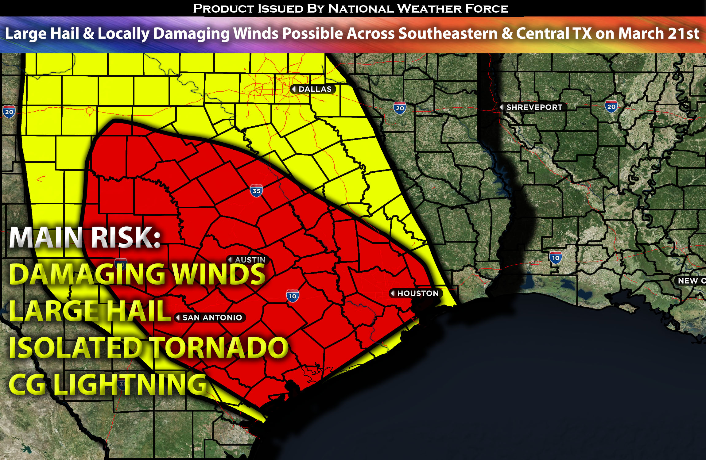
Main impact: large hail, damaging winds, isolated tornado and CG lightning.
Approximate Timing: Depending on when destabilization can occur storms would be expected to pop around early morning hours with another round in the afternoon/evening hours.
Locations Impacted: Texas southeast and central.
Overall Forecast:
An upper low and accompanying trough over northern Mexico and the southern Rockies are set to shift eastward across the Southern Plains on Thursday. Early convection, supported by a weak lead shortwave impulse from the subtropical jet stretching across south Texas into the western Gulf on Thursday morning, will initiate via warm advection near the Middle/Upper Texas Coast.
Organized convection will be fostered by favorable vertical shear in the region. The day may start with isolated strong to severe supercells, evolving into a cluster as the system moves toward the Gulf and Louisiana coast by late morning or early afternoon. The presence of steep mid-level lapse rates and elongated/straight hodographs above around 2-3 km, amidst deep-layer instability, suggests a potential for large hail as the main risk. Later in the day, additional convection is expected to develop in central Texas by late afternoon or early evening as the upper trough moves eastward and increased large-scale ascent impacts the area. This second wave of convection will move east overnight toward east Texas and western Louisiana, with severe potential primarily from northwest Texas south to the Hill Country and the Middle/Upper Texas Coast.
The presence of favorable vertical shear, especially towards the Hill Country, will facilitate organized convection, though weak lower-level capping may limit a more intense or widespread severe event in the evening. Nevertheless, even elevated convection poses a large hail risk. Initial cells are anticipated to merge into clusters. While boundary-layer moisture will be more limited further north in Texas, with surface dewpoints mostly in the 50s F, elevated instability should be sufficient for isolated severe storms to produce large hail and strong gusts.
Impact:
Scattered ongoing storms are expected to continue through the morning and afternoon hours, with a few becoming strong/severe, mainly capable of producing large hail and locally gusty, damaging winds (perhaps an isolated tornado). Then, another round of scattered thunderstorms, with a few expected to be severe, is anticipated around the evening hours, with the best risk of severe storms being well off the coast of the Texas area due to capping and limited moisture. Despite that, storms are still expected to be scattered in nature, clustering together and mainly capable of producing large hail and damaging winds.
Stay tuned for more updates.
Sina⚡⚡
With over a decade of experience in forecasting severe thunderstorms, this individual is a seasoned forecaster and developer. Their expertise in severe weather forecasting and computer science is entirely self-taught, complemented by a foundation in Atmospheric Science from UNCO and an IT background from WGU. They have dedicated their efforts to developing innovative tools that enhance the accuracy of analyzing large hail and tornadoes. As a significant contributor to National Weather Force & Southern California Weather Force, they have played a crucial role in providing accurate and timely information, as well as developing tools to keep those affected well-informed.