
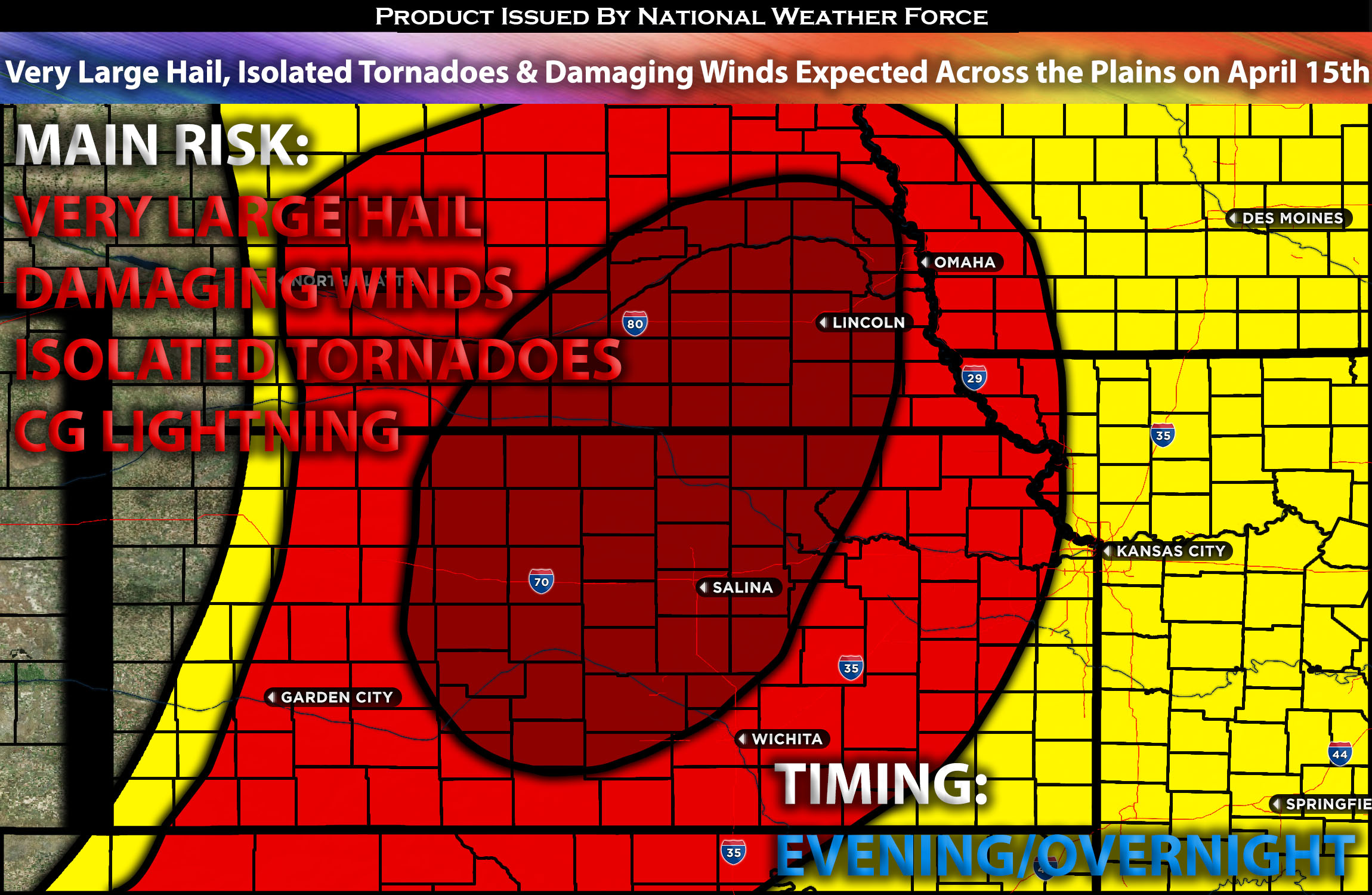
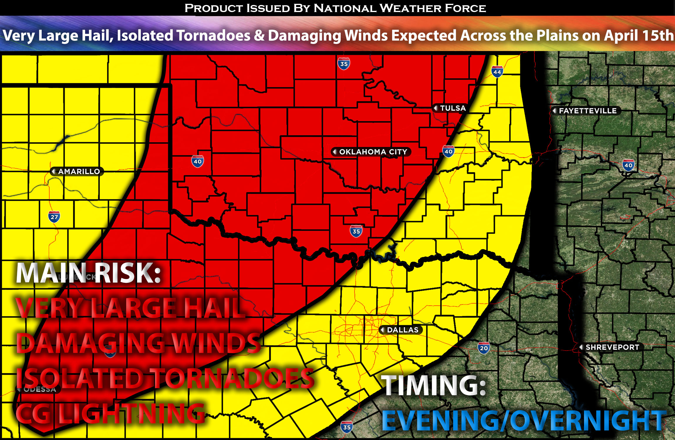
Outlook Across the Central/Southern Plains:
Severe storms are highly likely across the southern to central Great Plains, primarily later on Monday evening and into the night. The potential for large to very large hail, damaging wind gusts, and a few tornadoes exists (not being the main threat), with very large hail posing the main threat.
Locations Impacted: Texas, the northern and western areas; in Oklahoma, the south, central, north, northwest, northeast, east, and the Panhandle; in Kansas, the south, central southeast, north, northeast, and east; and in Nebraska, the south, central, north, northeast, and east sectors.
Overall Forecast:
By Monday afternoon, expect an enhanced shortwave trough within an upper-level low to be positioned over the Rockies and Great Basin. A coordinated movement of multiple embedded disturbances is likely to progress eastward across the southern Rockies and Southwest, approaching the central to southern High Plains by early Tuesday morning. A particularly robust flow is forecasted for western Oklahoma and northern Texas. This flow will contribute to a notable increase in atmospheric dynamics as an intense mid-level jet stream develops from northwest Texas into southern Kansas Monday night. The expectations are for more robust storms to be more in central/northern Plains with a less significant impact further south.
At the surface, moisture from the northwest Gulf will suffice for severe storms, but not to the extent of sparking an extremely large outbreak especially for tornadoes that require higher levels. Agreement on a band of surface dew points in the low to mid-60s advancing ahead of the dryline, mainly impacting the Panhandles, western Oklahoma, and western North Texas. An escalation in convective storms is on the cards for Monday night, with an expected merging of the cold front and dryline. The limited surface-based buoyancy suggests that initial supercells will likely evolve into smaller clusters rather than a widespread linear convective system. The overarching concern will be for large to very large hail due to steep mid-level lapse rates and conducive wind profiles for supercells. The tornado risk will be more pronounced in regions with ample low-level moisture where a distinct supercell pattern can persist, particularly in northwest Texas and western Oklahoma. Later into the night, a swath or two of significant damaging winds could unfold as the atmospheric flow strengthens, though dwindling instability may temper this risk. Continuous monitoring will be critical to ascertain the final placement of the dryline and the extent of moisture infiltration.
Main Risk: very large hail, damaging winds, isolated tornadoes and cloud-to-ground lightning.
Approximate Timing: Destabilization is expected to occur around Monday evening, with severe storms quickly forming and intensifying as they move northeastward across the impacted regions. Numerous clusters of storms are likely to develop from the southern to central Plains, potentially intensifying into the night before a more stable air mass arrives around midnight and into the early morning, diminishing the risk substantially. These clusters are anticipated to be capable of producing very large hail, some stones exceeding 2 inches in diameter, as well as damaging winds and possibly a few isolated tornadoes, especially during the evening if conditions are conducive. There is some disagreement among forecasts regarding severe storms in the Texas/Oklahoma area, which will require close monitoring.
Stay tuned for more updates.
Sina⚡⚡
With over a decade of experience in forecasting severe thunderstorms, this individual is a seasoned forecaster and developer. Their expertise in severe weather forecasting and computer science is entirely self-taught, complemented by a foundation in Atmospheric Science from UNCO and an IT background from WGU. They have dedicated their efforts to developing innovative tools that enhance the accuracy of analyzing large hail and tornadoes. As a significant contributor and partner at National Weather Force Innovations LLC, they have played a crucial role in providing accurate and timely information. Additionally, they have been instrumental in developing tools and organizing projects that focus on accuracy and performance, ensuring those affected are well-informed.