
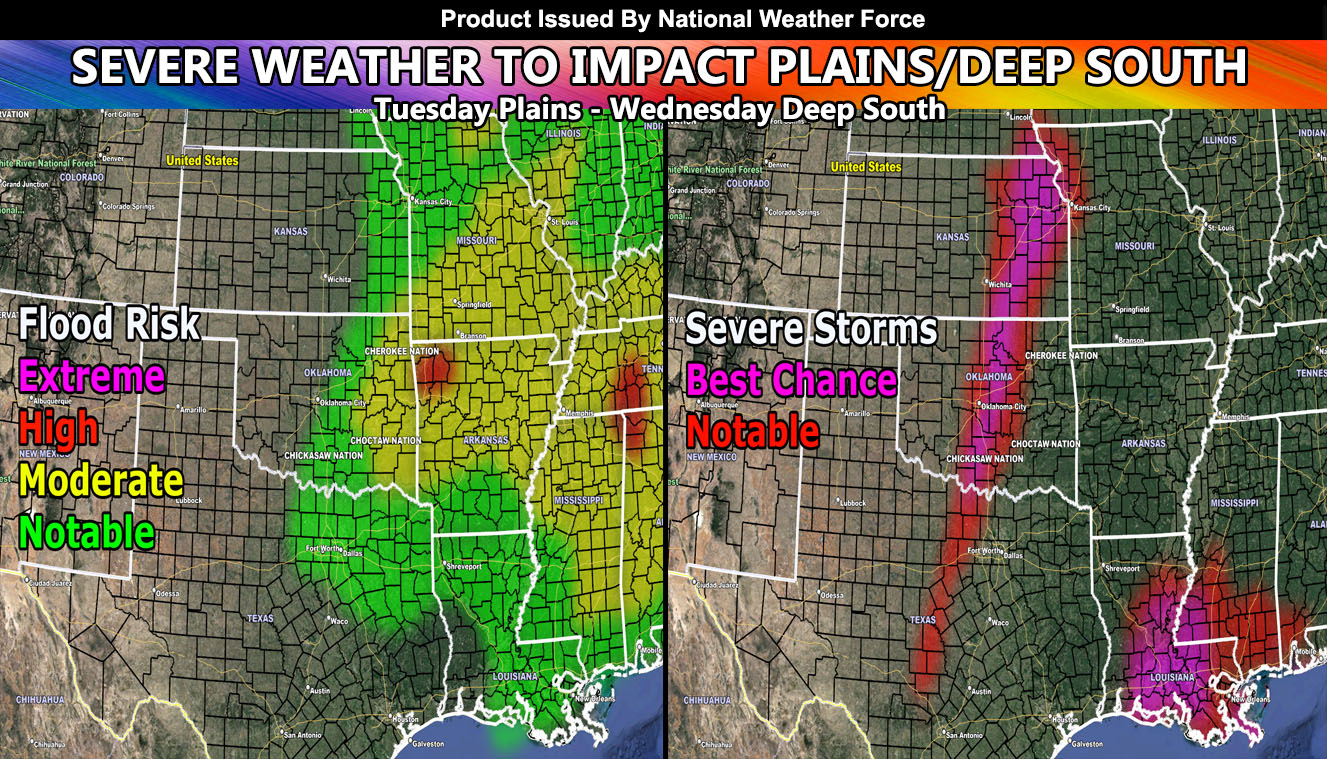
National Weather Force will be testing the new severe storms model out that will run along side the flood risk model already used in the forecasts and the first event will be this coming Tuesday into Wednesday with a severe weather event in the Plains and Deep South so read on for details and see the larger images of the article image …
FOLLOW the Facebook Page after reading this and interact with the post made about this, whether sharing, liking, or commenting … It will be answered
CLICK HERE TO FOLLOW THE MAIN FACEBOOK PAGE
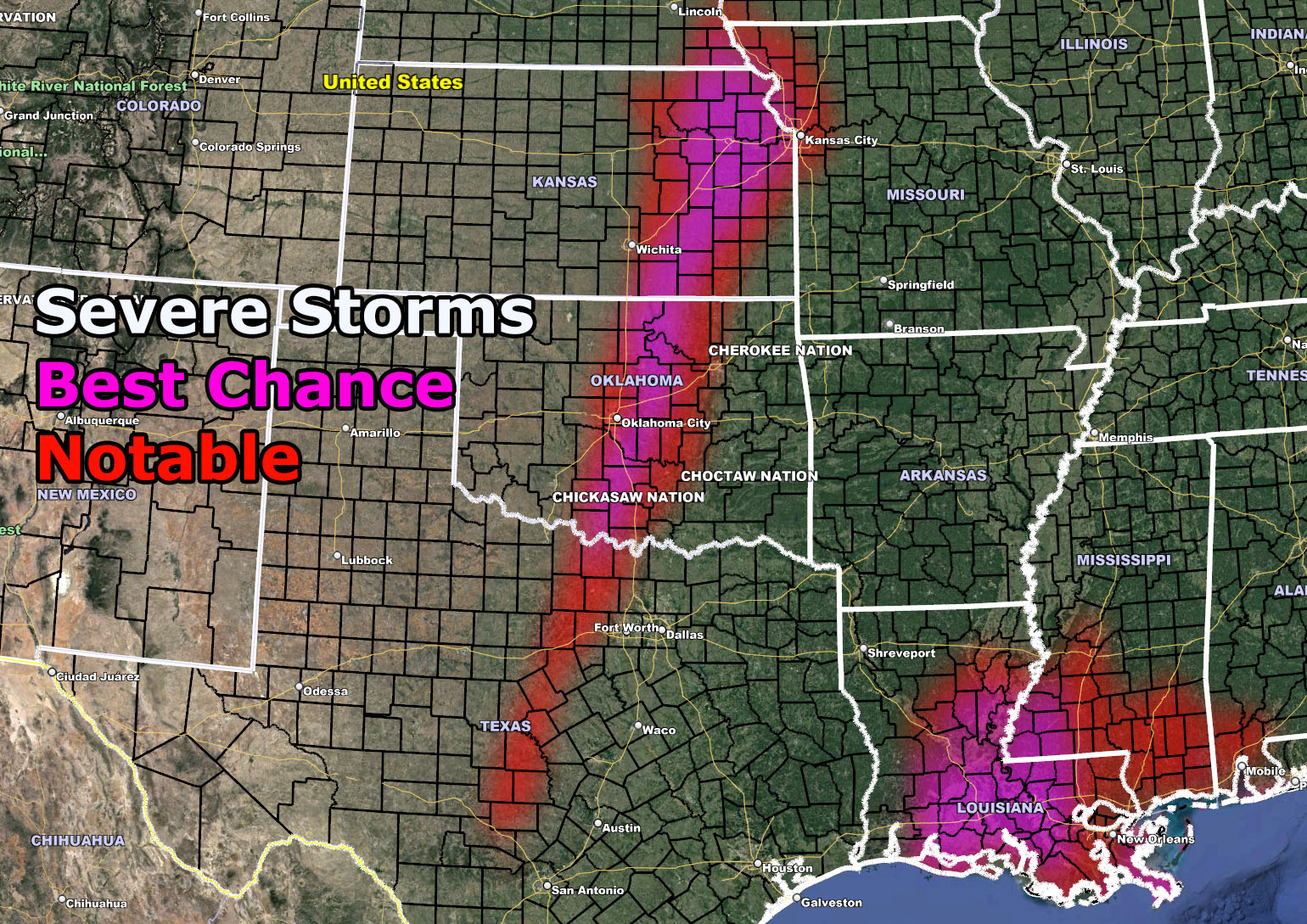
TUESDAY: Severe weather on Tuesday will be along a very narrow band from Texas to Southeast Nebraska and Northwest Missouri with Oklahoma and Kansas included. Hey Kansas City this is your first lightning show event of the season. This narrow band does not look to have too much instability with it. As you can see in the model images in this post, the band extends into Central Texas and out of the ‘notable’ flood risk zone. This means that supercells will form along the dryline, some being discreet and the as the night moves along they will advanced eastward into the Dallas area as a merged storm system capable of some flooding. However, noted in the severe model that it doesn’t reach the DFW areas. The storms do, however likely the model showing less instability at the moment will keep the severity down. Still, anywhere along that line, including Oklahoma City, you can see all modes of severe weather from hail/wind/tornado risks …
WEDNESDAY: This is when the line of storms finally moves into Louisiana. As you can see, this area is a bit wider, similar to two weeks back. Storms will start at sun-up and the daytime heating will work from there. Storms are expected to be the most severe in Central/Southern/and Eastern Louisiana and Southwest Mississippi then. All modes of severe weather will be possible from hail/wind/tornado risks … This area will be more severe than Tuesday’s storms in the Great Plains.
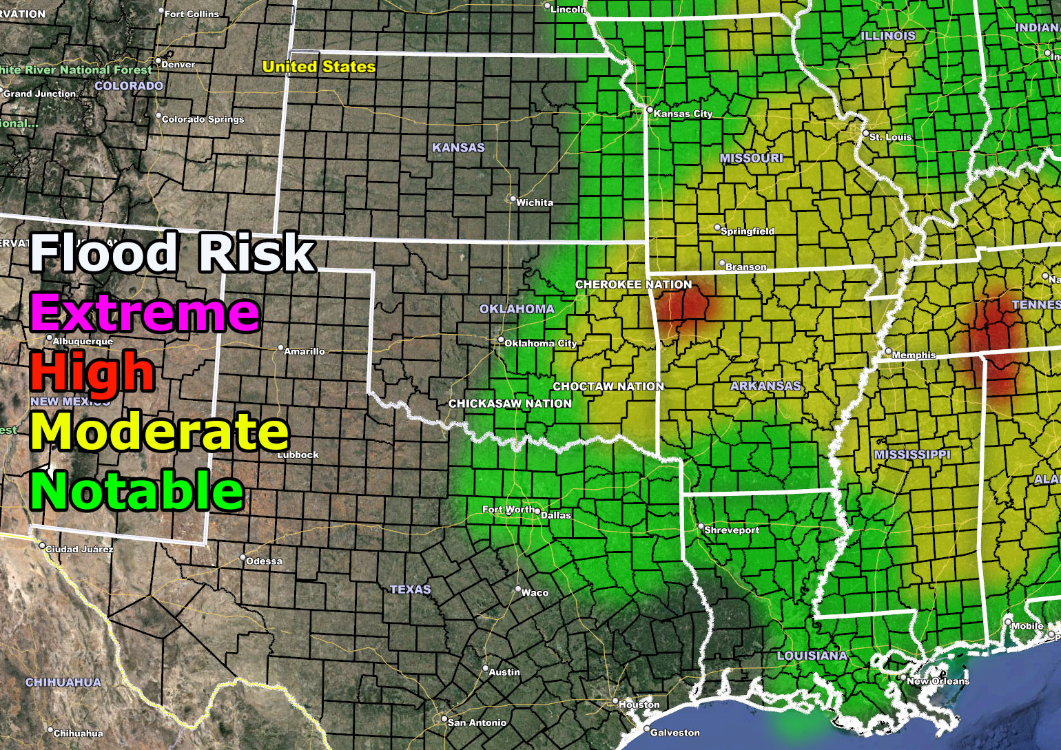
LONGER RANGE: Storms will lose their instability in Alabama/Central Tennessee/Northern half of Georgia overnight on Wednesday and into Thursday morning. If you’re in these areas you will see a flood hazard however regardless of the loss of severe storm dynamics. I do not see a severe storm event for Eastern TN with this at the time and the Carolinas will be monitored for further updates for your Thursday.
UPDATES WILL BE MADE HERE AT NATIONAL WEATHER FORCE SHOULD CHANGES NEED TO BE MADE OR FURTHER ALERTS ISSUED …
Please use the images below for this longer range forecast and see what area risks you are in. Both images are clickable…
FLOOD CRITERIA:
Anything NOTABLE/MODERATE or higher is Flood Watch criteria
HOW TO GET THESE ALERTS?.
SIGN-UP TO THE FREE NWF E-MAIL ALERT SYSTEM FOR YOUR AREA HERE WHERE YOU PICK YOUR AREA IN YOUR OWN CONTROL PANEL BY STATE LOCATION AND GET NOTIFIED WHEN A POST IS MADE FOR YOU https://www.nationalweatherforce.com/national-weather-force-email-alert-system-sign-up/
FOLLOW the Facebook Page after reading this and interact with the post made about this, whether sharing, liking, or commenting … It will be answered
CLICK HERE TO FOLLOW THE MAIN FACEBOOK PAGE