
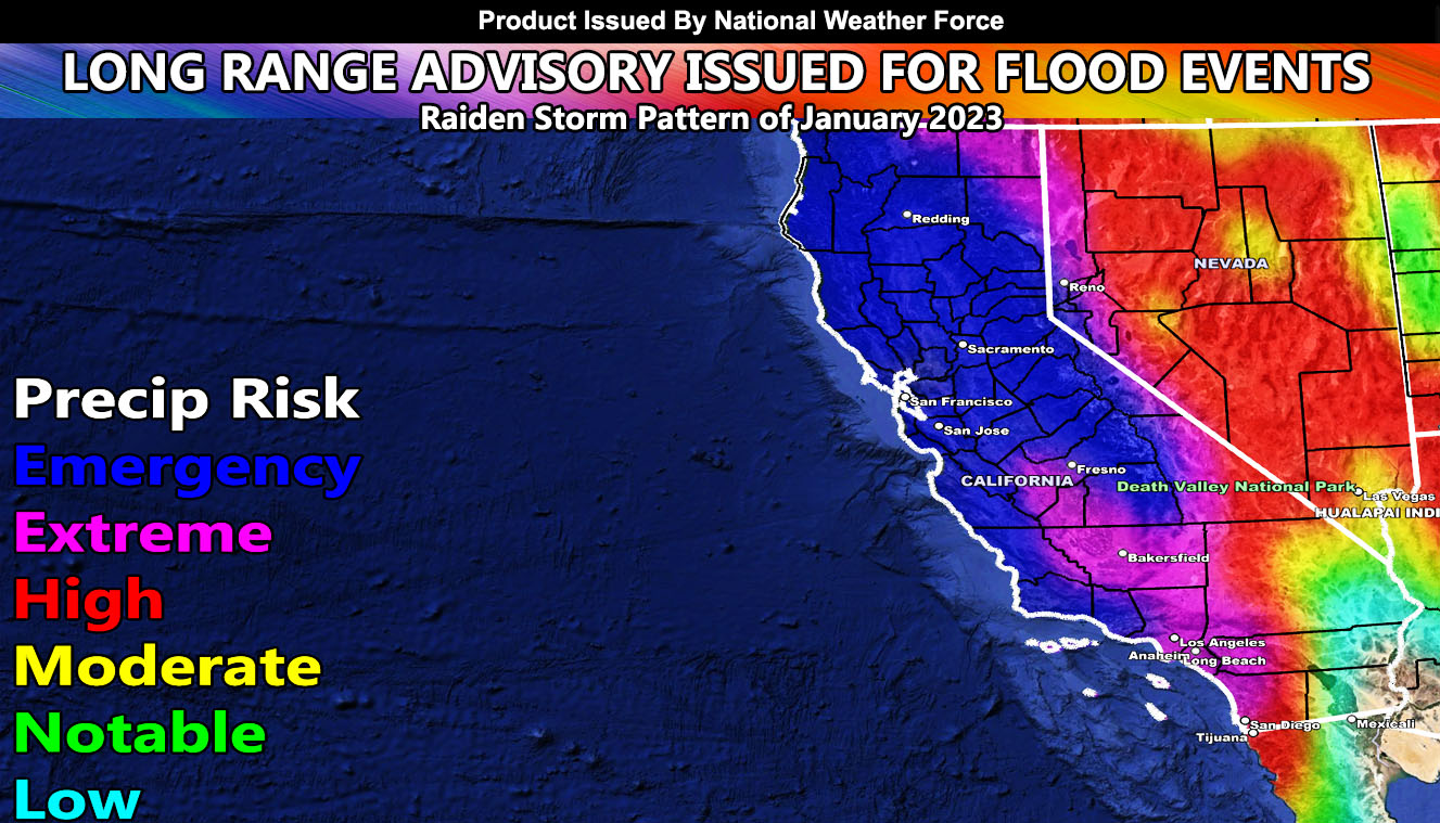
National Weather Force has issued another Long-Range Weather Advisory for California with another Atmospheric River that will last from the end of this next weekend (January 7-8) and through the middle part of the month, with multiple storm systems in a line, including the entire major metropolitan areas under either an extreme or emergency risk for flooding and mountain snow, including the Reno/Tahoe areas. This is another Raiden Storm Pattern, but since it will envelope a lot of the month, it will be the Raiden Storm Pattern of January 2023 so read on for details …
NOTE: If you are in Southern California, Click Here For That Article and do not forget to Follow Southern California Weather Force for your area’s updates
The upper-level jet stream that now extends from the United States Mainland westward to Asia is remaining in place. A ridge of high pressure south of Hawaii is continuing to block any type of amplitude process within this system. This is something that has not been seen for a very long time, probably a once in 20-year event. This is continuing to eject tropical moisture into California.
This next Atmospheric River will be the second one this season that will bring high levels of flooding risk to California. This might very well exceed the current pattern we are in. National Weather Force Long Range Models are indicating emergency conditions across Central and Northern California.
As such, January 2023 will be above average in rainfall as the official National Weather Force projection.
This comes months after the forecast here at Southern California Weather Force stated that the 2022-2023 season would not be a normal La Nina (Click Here To Read That), and the margin of forecast precipitation in Los Angeles would be 14-18″ of rain, middle part being 16″. Can they exceed it? It all depends on the rest of the season after this month, but trends are looking that the margin will be met, where NOAA went warm and dry due to a La Nina and at Southern California Weather Force went opposite. La Nina and El Nino do not dictate what happens in California. There are more factors in place many in the field do not understand yet, which is where I come in.
A Raiden Storm Pattern is a pattern in the long range that was predicted before any other source or app available today, named after the discoverer as a comet is named after their discover. Weather forecasting is a gray area, and no prediction is ever respected or covered by others in the field, therefore it had to be done to create the Raiden Storm Pattern term.
If you are reading this, now take the proper precautions.
———————————————————-
SIGN-UP TO THE FREE NWF E-MAIL ALERT SYSTEM FOR YOUR AREA HERE WHERE YOU PICK YOUR AREA IN YOUR OWN CONTROL PANEL BY STATE LOCATION AND GET NOTIFIED WHEN A POST IS MADE FOR YOU https://www.nationalweatherforce.com/national-weather-force-email-alert-system-sign-up/
FOLLOW the Facebook Page after reading this and interact with the post made about this, whether sharing, liking, or commenting … It will be answered
CLICK HERE TO FOLLOW THE MAIN FACEBOOK PAGE
FIND NATIONAL WEATHER FORCE ON THE NEWSBREAK APP – CLICK HERE TO FOLLOW
———————————————————-
WHAT IS NWF? This page/site is a custom weather forecast office for higher class events. Whether tornado, flood, winter, hurricane, or long-range issuance, the alert system works for your area. There are times you will see things here not posted elsewhere, or not at all.
The forecasts here are not developed by outside sources and is a full stacked private weather office for the nation, the first of its kind in issuing weather watches/advisories to the people in a private forum …
All you have to do is like/follow and the newsfeed will target your area. Oh, and get on the free e-mail alert system, you’ll be glad you did. Information is in the comment sections in alerts that matter the most to you, your family, or your friends – …
———————————————————-
📷 📷Raiden Storm📷📷
Master General Meteorologist – is a consulting meteorologist with over 25 years’ experience for over 50 different companies, including energy, agriculture, aviation, marine, leisure, and many more areas. He has certs from Mississippi State for broadcast met and Penn State forecasting certs MET 101, 241, 341 and 361 as a meteorologist, but before then was completely self taught, barely learning a thing from the schools that he did not already know.
Both short and long-range is very important to know in those jobs so you can bet on accuracy here. He is versed in fields like Western USA, Tornadoes, Floods, Hurricanes, High Winds, Fire Behavior, Snow and Blizzards, Short Range, Long Range, Seasonal, and Life-Threatening decisions with over 25 years experience, out-forecasting all weather services available today with lead-time and precision, which makes him a focus of ridicule and envy.
NOTE: Alerts are posted on here, be it a tornado watch, etc, and these alerts are issued from this office and nowhere else. At times, which is often, you will see an alert forecast posted on here that you do not see elsewhere. That is fine, the track record of the main office is very high so maintain to follow an event when posted.